Pacific Island weather and the MJO
Dr Mike Revell, NIWA
The Madden-Julian Oscillation (MJO) is the major mode of variability of the tropical atmosphere-ocean system on time scales of 30 to 70 days. The MJO organizes convection into an eastward-propagating envelope of smaller-scale disturbances. This envelope moves eastward at between 5 and 10 ms-1 on average, generally forming in the tropical Indian Ocean and dissipating over the central Pacific. It is generally most active during the southern hemisphere summer and autumn. This convective disturbance generates atmospheric circulation anomalies throughout the tropics and extra-tropics, causing active and break periods in the Asian and Australian monsoons and possibly playing a role in initiating and modulating El Niño events. Although the MJO is sporadic, once a disturbance is initiated there is a reasonably good measure of predictability associated with its evolution.
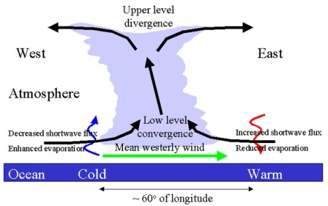
Early theories for the MJO viewed it as an eastward propagating, equatorially confined gravity wave in the atmosphere. The natural propagation speeds for such waves in the atmosphere seem considerably faster than the observed speed of the MJO, particularly when it is at its most intense over the warmer waters of the Indian and western Pacific oceans. More recent work suggests that in this latter region an ocean–atmosphere coupled mechanism may apply. Variations in cloudiness and low level winds associated with the MJO appear to induce changes in sea surface temperature (SST) to the east and west of the convection. These changes in SST then feed back on the atmosphere affecting the eastward propagation of the convection. This mechanism is schematically represented in Fig. 1. If this coupling is important it would help explain why current long range forecast models with prescribed SST at the lower boundary are not able to accurately reproduce the MJO.
At NIWA we are currently conducting research to establish whether or not the MJO has a predictable effect on the weather in the South Pacific between 10 days and a season ahead. Using satellite observations of outgoing longwave radiation (OLR), which is reduced in regions of high, cold cloud tops associated with deep convection, we have derived an index for the MJO. This index, in conjunction with streamfunction patterns at 200hPa, will be compared with radiosonde, surface and European Center for Medium-Range Weather Forecasting (ECWMF) reanalysis weather data in the South Pacific region, using simple statistical relationships to determine lag correlations. If we can establish any of these correlations are statistically significant then we will attempt to forecast the influence of the MJO. We do not expect the results to be dramatic (because many other factors influence the weather) but it may be possible to indicate average rain, wind or temperatures slightly above or below normal for the next month.

