Climate developments in December 2009
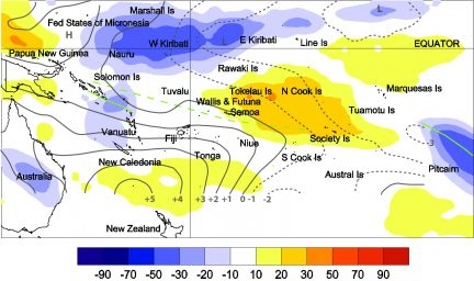
Enhanced convection along a partially southwest displaced South Pacific Convergence Zone (SPCZ) were seen near northern Vanuatu and near Pitcairn Island during December. Likewise, convection along the Equator generated significant rainfall in Western Kiribati. Suppressed convection existed in the central portion of the southwest Pacific, particularly around the Northern Cook Islands and in French Polynesia.
The regional circulation in December was characterised by more frequent low pressure in the northeast sector of French Polynesia, and and higher than normal pressure to the northwest of New Zealand in the Tasman Sea. This pattern resulted in more frequent easterly and southeasterly anomalies across the much of southwest Pacific, except in the Marquesas. Some southerly flow entered the region from the east of New Zealand, and easterly anomalies were particularly evident across Fiji, Vanuatu, and New Caledonia.
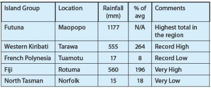
Very high rainfall was recorded at only a few stations in the region this past month, either due to convection associated with the Intertropical Convergence Zone (ITCZ) or TC Mick. In Western Kiribati, 555mm (185% of normal) of rain fell during December at Tarawa, and this was a record high. It is the sixth month in a row with considerable rainfall at Tarawa. Positive rainfall anomalies in Western Kiribati are still more pronounced than in central and eastern parts of Kiribati. In Futuna, more than one meter of rainfall was recorded at Maopopo, with two consecutive days of having recieved 200mm or more. High rainfallwas also recorded in Rotuma and northern Tonga due to TC Mick passing through during the middle of December.

Outgoing Long-wave Radiation (OLR) anomalies, in Wm2 are represented by hatched areas. High radiation levels (yellow) are typically associated with clearer skies and lower rainfall, while cloudy conditions lower the OLR (blue) and typically result in higher rainfall. The December 2009 position of the South Pacific Convergence Zone (SPCZ) southwest of normal near the Solomon Islands, but was incoherent west of Fiji and slightly northeast of normal to the north of Pitcairn Island. The average SPCZ position is identified by the dashed green line, which is based on mean January rainfall for the South Pacific. Mean sea level (MSL) pressure anomalies (in hPa) are shown as solid and dashed black lines.

