Tropical rainfall and SST outlook: January to March 2010
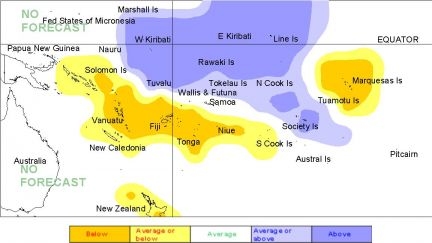
During January – March 2010, a region of suppressed convection is likely in the southwest Pacific encompassing The Marquesas, Niue, Fiji, Tonga and Vanuatu. Below average rainfall is expected for all of those island groups. Near or below normal rainfall is expected for Wallis & Futuna, New Caledonia, the Southern Cook Islands, and the Solomon Islands. Enhanced convection is likely along the Equator extending from Western to Eastern Kiribati, and also near Tuvalu and the Society Islands, with an expectation of above average rainfall for those islands. Near or above average rainfall is forecast for the Northen Cook Islands, the Tuamotu Archipelago and Tokelau. Near normal rainfall is forecast for Papua New Guinea, Pitcairn Island, Samoa, and the Austral Islands.
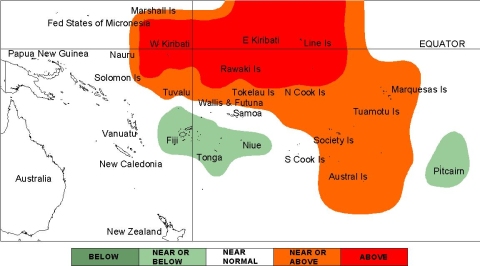
The global models are continuing to show elevated temperatures in the near equatorial Pacific and the northeast part of the Southwest Pacific. Some anomalies a have strengthened from past months, and a warming pattern is seen in many models for French Polynesia. Cold anomalies have appeared to strengthen around Fiji in many models. Above average sea surface temperatures are forecast for Eastern and Western Kiribati. A region of near or above average sea surface temperatures is forecast around Tokelau, Tuvalu, the Northern Cook Islands, and all of French Polynesia. Average or below average SSTs are forecast for Fiji, Niue, Tonga, and Pitcairn Island. Near normal SSTs are forecast for the remainder of the southwest Pacific.
The confidence in the multi-model ensemble forecast skill for this seasonal rainfall outlook is moderate to moderately high. In the past, the average region-wide hit rate for rainfall forecasts issued in January is 57%, 4% lower than the longterm average for all months combined. The SST forecast confidence is mostly high, but the greatest uncertainty is localised around the Marquesas.

Rainfall outlook map for January to March 2010

SST outlook map for January to March 2010
