Climate developments in January 2009

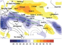
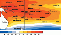
The South Pacific Convergence Zone (SPCZ) activity was displaced south and west of normal during January, and was more consolidated than last month. A region of enhanced rainfall due to intensified convection was observed during January 2009 over northeast Australia, and in the south Pacific extending from the Solomon Islands southeast to the Southern Cook Islands. Very high amounts of rainfall occurred within this band, and are highlighted in this issue. Suppressed convection intensified during the month near the Equator, and encompassed the region northeast of the Solomon Islands that included Nauru and Western Kiribati, and extended across the southwest Pacific to the Marquesas. The regional circulation for the month was characterised by more frequent high pressure across the northeastern half of the South Pacific; and lower than normal pressures east of northern New Zealand and south of the Southern Cook Islands.
Many rainfall records were shattered in Fiji in January 2009 (see feature article), with most stations receiving 140–450% of normal rainfall. Similarly, northeastern Australia (220–250% or normal), Vanuatu (135–200% of normal), and Tonga (120–340% of normal) received well above normal rainfall for many stations. Enhanced rainfall was also localised near Pitcairn Island. All of the reporting stations for Tonga received greater than 300mm rainfall in January, and two of those stations were close to or exceeded previous monthly record highs.
Lower than normal rainfall was recorded at many stations in French Polynesia, with Hiva Hoa in the Marquesas Islands receiving 34 mm of rainfall (22% of normal). Elsewhere in the eastern half of the southwest Pacific, the stations in the Tuamotu archipelago and the Austral Islands all recorded normal or below normal rainfall, except Rikitea, which received a record high total of 433 mm (297% of normal).
Continuing the trend from last month, many stations in New Caledonia received well below normal rainfall (30–60%) during January. Northern New Zealand also experienced a relatively dry month, with the northern part of the country recording well below normal rainfall (20–60% of normal). The Solomon Islands also had a relatively normal month, except at Honiara and Henderson, which received 170–190% of normal rainfall.
| Island Group | Location | Rainfall (mm) | % of average | Comments |
|---|---|---|---|---|
| Fiji | Lautoka | 1291 | 348 | Record high; Highest monthly total in the region |
| Tonga | Fua’amotu | 570 | 284 | Record high |
| Fiji | Penang | 1228 | 310 | Record high |
| Tuamotu | Rikitea | 433 | 297 | Record high |
| Marquesas | Hiva Hoa | 34 | 22 | Very low |
| New Caledonia | Belep | 60 | 25 | Very low |
Soil moisture in January 2009

Estimates of soil moisture shown in the map (right) are based on monthly rainfall for one station in each country. Currently there are not many sites in the water balance model, but it is planned to include more stations in the future.
The information displayed is based on a simple water balance technique to determine soil moisture levels. Addition of moisture to available water already in the soil comes from rainfall, and losses via evapotranspiration. Monthly rainfall and evapotranspiration are used to determine the soil moisture level and its changes. Please note that these soil moisture calculations were made at the end of the month, and for practical purposes, generalisations were made about the available water capacity of the soils at each site.
Nadi (Fiji), Hanan (Niue), Port Vila (Vanuatu), Rarotonga (Southern Cook Islands), and Apia (Samoa) project moist (at or near field capacity) soil moisture conditions. Soils are moderate for the time of year at Nuku’alofa (Tonga).
El Niño/Southern Oscillation (ENSO)


During January, La Niña conditions were established in the equatorial Pacific Ocean, with the tropical Pacific atmosphere exhibiting moderate La Niña characteristics. The SOI remained positive with a January value of +0.9 (NDJ mean +1.3),.The easterly trade winds remained strong during December about and west of the Date Line, now have weaken slightly across the tropical Pacific, but still appear to strongest around 160°E.
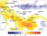
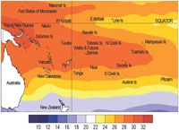
SST anomalies in December were below average across the Equatorial Pacific: the NINO3 anomaly for strengthened in January to –0.7°C (3-month mean –0.3°C), as did the NINO4 anomaly which is –0.7°C (OND mean 0.4°C). Equatorial subsurface anomalies that strengthened at the thermocline in December (with a –4°C anomaly centred near 140°W below 100m) now appear to be weakening somewhat in the eastern equatorial Pacific with some weak warming at the surface near South American Coast. West of the dateline sub-surface warming appears to be occurring and intensifying towards 160°W.
Tropical Pacific precipitation patterns continue to exhibit La Niña characteristics, with the TRMM ENSO precipitation index at -0.82 for January (up from -1.34 in December). OLR anomalies show extremely suppressed equatorial convection about and west of the Date Line and the eastern Indian Ocean for January as a whole, with enhanced convection over the maritime continent and northern Australia. The MJO in the Indian Ocean is weak and is expected to remain so into the second week of February.
Several climate models assessed by NIWA predict weakening La Niña conditions over the next three-months (FMA). The majority indicate ENSO-neutral conditions during late autumn and early winter 2009. The NCEP discussion of 8 January indicates a continuation of below average sea surface temperatures and continuation of La Niña through early 2009. The IRI summary of 14 January indicates a 55% chance of La Niña conditions persisting over the coming season, and 45 – 50 % chance of a return to ENSO-neutral conditions.
Tropical Cyclone Guidance
Tropical cyclone Hettie, the first to form in the southwest Pacific during the 2008–09 season, developed on 28th January to the southeast of Fiji. The system brought southerly winds and heavy rain to the central region of Fiji on the 28–29 January, and then tracked to the southwest before dissapating on 30 January. Conditions in the tropical Pacific are still likely to affect the chances of tropical cyclone (TC) activity for several countries between January and May 2009. There is an increased risk of TC occurrence for countries west of the Date Line, including Vanuatu, the Solomon Islands, and New Zealand, and a slight risk increase for New Caledonia. Reduced risk is expected for Samoa, Tonga, and Niue.
Forecast validation: November 2008 to January 2009
A region of suppressed convection was expected to encompass the central and eastern Southwest Pacific, in a region extending from Western Kiribati to the Marquesas Islands and the Society Islands, including Tuvalu, Tokelau, Wallis & Futuna, Samoa, the Northern Cook Islands, and the Tuamotu archipelago. Below normal or near–to–below normal rainfall was expected for those countries. Enhanced convection was expected to be focused near Papua New Guinea, and also near Vanuatu, New Caledonia, Tonga, Fiji, and Niue with above average rainfall. Near–to–above average rainfall was forecast for the Southern Cook Islands, the Austral Islands, and Pitcairn Island, while no clear precipitation forecast was offered for the Solomon Islands.
The rainfall outlook for the November 2008–January 2009 period was calculated for 17 island groups (one island had a forecast of ‘climatology’, which is unscoreable, and three did not report values). The global station ‘hit’ rate was 71%, 7% higher than average for forecasts made during November and 10% higher than the average for all months combined. Rainfall was overprojected for Vanuatu and New Caledonia, and either over– or under– projected for parts of French Polynesia.
