A warm and wet spring for much of New Zealand
|
Temperature |
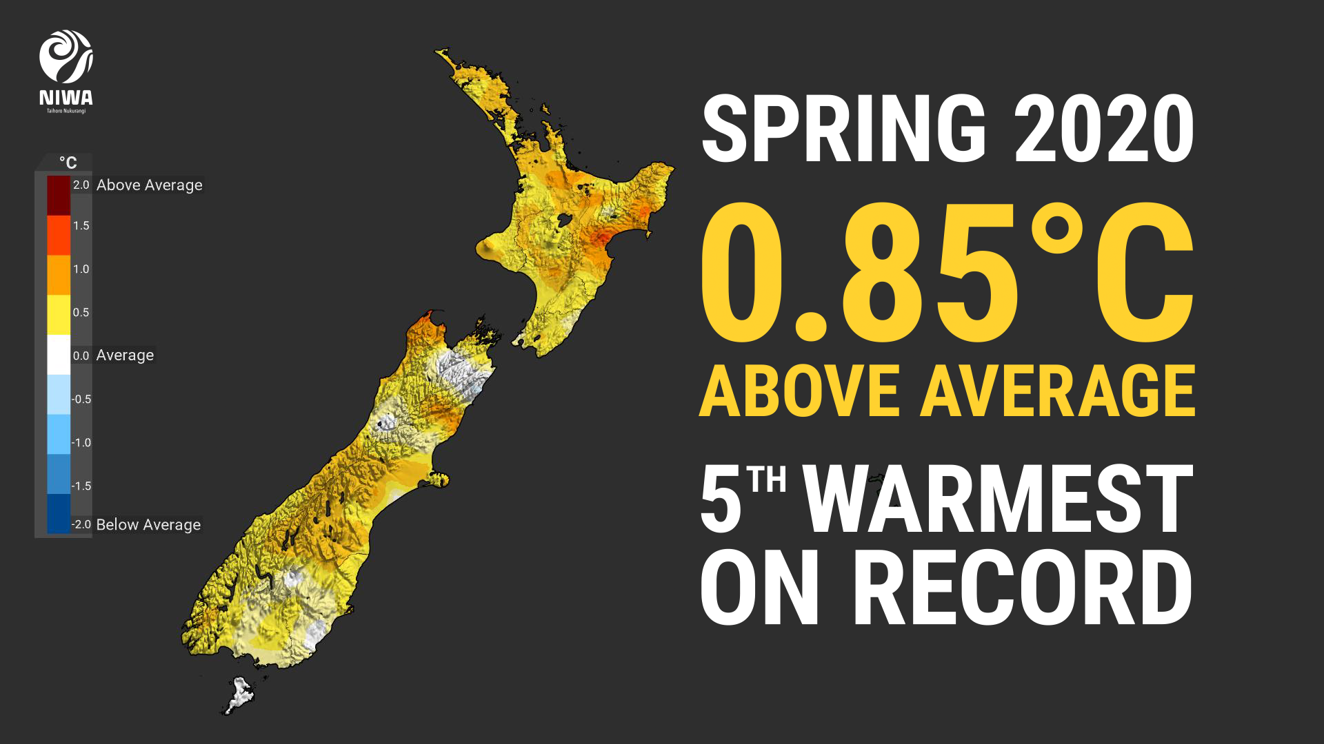
Spring 2020 was New Zealand’s 5th-warmest spring on record. The nationwide average temperature was 12.9°C (0.9°C above the 1981-2010 average from NIWA’s seven station temperature series which begins in 1909). Temperatures were above average (0.51 to 1.20°C above the spring average) or well above average (>1.20°C above the spring average) across nearly all of the North Island and large portions of the South Island. However, near average spring temperatures (within 0.50°C of the spring average), were observed in parts of Wellington-Wairarapa, Marlborough, upper West Coast, interior Otago, and Southland. |
|
Rainfall |
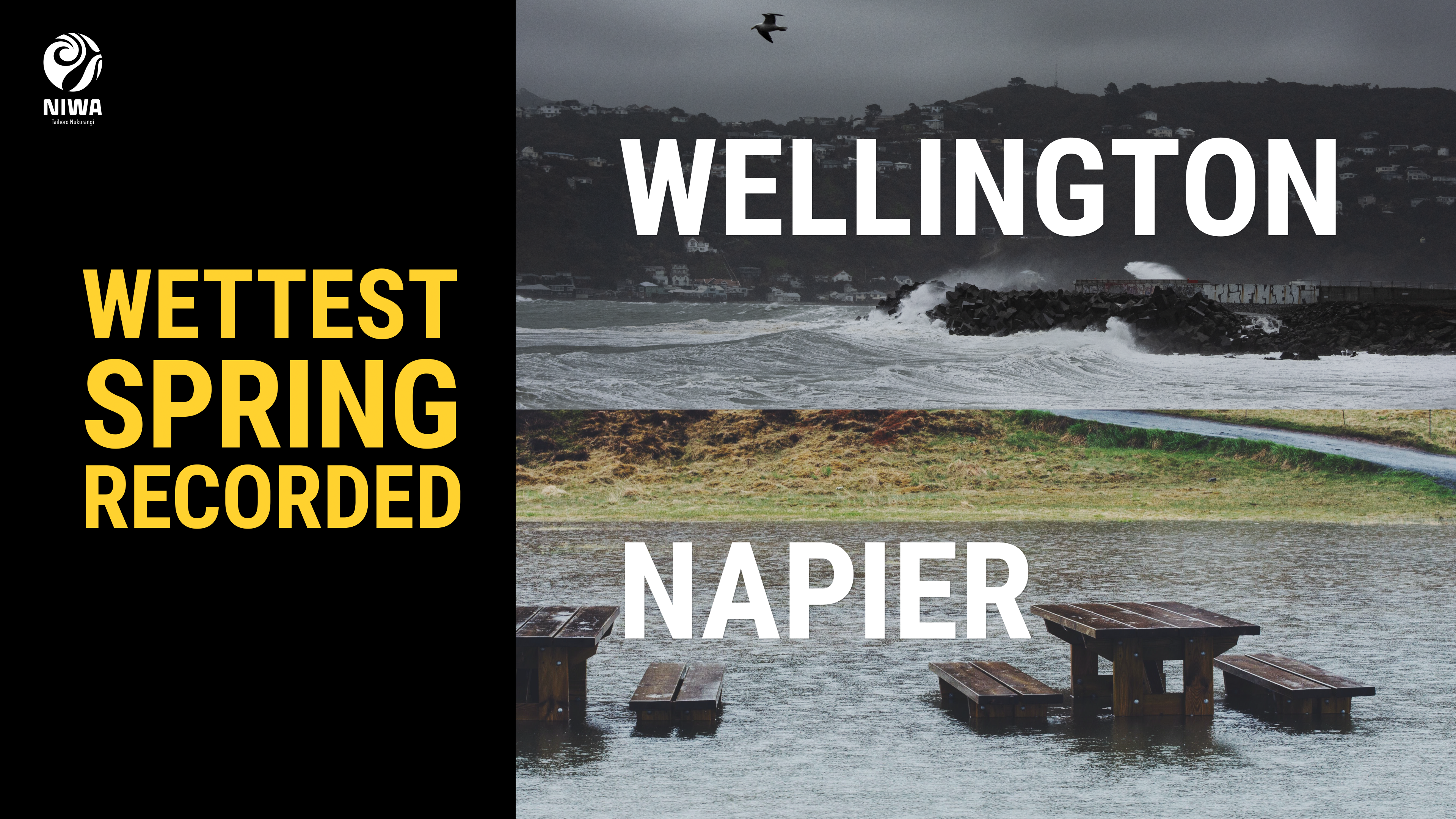
Spring 2020 rainfall totals were generally above normal (120-149% of the spring normal) or well above normal (>149% of the spring normal) across the lower half of the North Island, Nelson, Tasman, interior Otago, Fiordland, and coastal Southland. Rainfall was generally below normal (50-79% of the spring normal) in much of Northland, Auckland, Coromandel Peninsula, Bay of Plenty, Banks Peninsula, and near Dunedin. Elsewhere, rainfall was near normal (80-119% of the spring normal). |
|
Soil moisture |
At the end of spring, soil moisture levels were higher than normal for most of the North Island south of Hamilton, as well as Nelson-Tasman. Soil moisture levels were lower than normal for much of Northland to northern Waikato and the southern half of the South Island. |
Overview
Spring 2020 was characterised by mean sea level pressure that was higher than normal over, and to the east and west of the North Island. This pressure pattern delivered slightly more northeasterly winds than normal to the North Island, and slightly more westerly winds than normal to the South Island. This pattern was generally associated with La Niña conditions in the equatorial Pacific Ocean. Sea surface temperatures (SSTs) surrounding New Zealand were warmer than average during spring, and this exerted a warming influence on the country’s air temperatures.
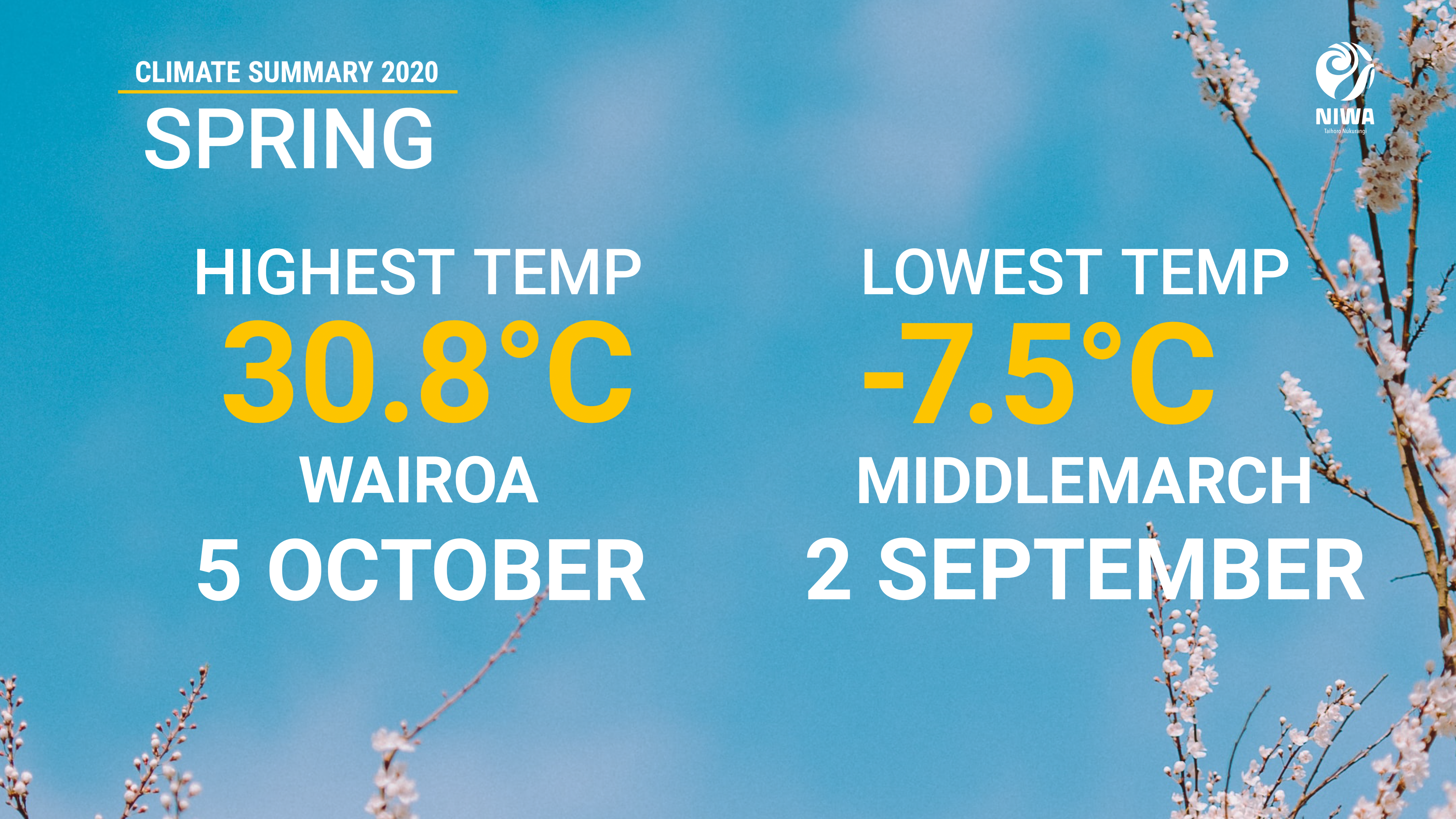
The nationwide average temperature for spring 2020 was 12.9°C (0.9°C above the 1981-2010 average from NIWA’s seven station temperature series which begins in 1909), making it New Zealand’s 5th-warmest spring on record. Four of the five warmest springs have occurred during La Niña conditions, including New Zealand’s warmest spring in 1988. Temperatures were above average (0.51 to 1.20°C above the spring average) or well above average (>1.20°C above the spring average) across nearly all of the North Island and large portions of the South Island. However, near average spring temperatures (within 0.50°C of the spring average), were observed in parts of Wellington-Wairarapa, Marlborough, upper West Coast, interior Otago, and Southland. Spring started on a chilly note, when several South Island locations observed near-record low September daily maximum temperatures on 1 September. Conversely, early October featured unseasonably warm weather as a warm air mass arrived from Australia. On 5 October, Wairoa reached 30.8°C, which is only the third year in the last decade that New Zealand observed a 30°C temperature in the month of October. This was also New Zealand’s warmest temperature during spring 2020.
Spring 2020 rainfall totals were generally above normal (120-149% of the spring normal) or well above normal (>149% of the spring normal) across the lower half of the North Island, Nelson, Tasman, interior Otago, Fiordland, and coastal Southland. Rainfall was generally below normal (50-79% of the spring normal) in much of Northland, Auckland, the Coromandel Peninsula, Bay of Plenty, Banks Peninsula, and near Dunedin. Elsewhere, rainfall was near normal (80-119% of the spring normal). It was a particularly wet season in the eastern and lower North Island, where both Napier and Wellington had their wettest springs on record. Records in Napier began in 1870, and 1928 in Wellington. On 9 November, Napier's Nelson Park recorded 242.4 mm of rain, which was the wettest November day and wettest spring day on record for Napier, and the 2nd-wettest day overall in the city. A local state of emergency was declared in Napier due to widespread flooding causing landslips, power cuts and evacuations.
Further Highlights:
- The highest temperature was 30.8°C, observed at Wairoa on 5 October.
- The lowest temperature was -7.5°C, observed at Middlemarch on 2 September.
- The highest 1-day rainfall was 242 mm, recorded at Napier on 9 November.
- The highest wind gust was 189 km/h, observed at Cape Turnagain on 1 November.
- Of the six main centres in spring 2020, Auckland was the warmest, Dunedin was the coolest and driest, Wellington was the wettest, Christchurch was the sunniest, and Hamilton was the least sunny.
Download
- Climate Summary Spring 2020 [PDF 5.6MB]
