Building a hydrological model
Hydrological models enable us to predict river flows and floods, by using a computer to simulate water movement through a catchment from the point it falls as rain until it enters the stream channel. The hydrological model TopNet was developed at NIWA and is commonly used in New Zealand. Typical applications include flood forecasting, irrigation planning and estimates of climate change impacts on river flows.
Hydrological models such as TopNet are based on a simplification of the important water stores and flow pathways in a catchment. These could include surface flow, soil water, and shallow and deep groundwaters. When building a hydrological model, there are many choices as to how best to represent the flow pathways. We refer to the choice of water pathways and stores as the 'model structure'. Our current research at NIWA asks how we can choose the best model structure for a particular catchment in NZ? The range of different landscapes and geology in NZ makes it likely that different model structures would be required for different regions.
Using tracers to evaluate different models
One obvious way to test different model structures is to compare the river flow simulated by the model, with the actual flow measured at a gauge. But, we often find that many different model structures can simulate flow equally well. These models produce "the right answers for the wrong reasons", i.e. they simulate flow well despite having a poor physical representation of the catchment.
Hence, we have begun to ask whether we could take additional measurements to help evaluate our models. A major advance in hydrology over the last 20 years has been the measurement of natural isotope or chemical tracers in rainfall and river flow. Water moving through a catchment carries the chemical signatures of its source area. As water is stored and mixes in the soils, aquifers and river margins, the chemical signatures are also transformed and transported. Tracers can help identify the times and places where water entered the catchment. We can harness this ability to test whether our models also predict flow from the right times and places.
Water tracking models
Typical hydrological models such as TopNet cannot track individual 'parcels' of water from rainfall, through soil and groundwater and into the river. This means they cannot immediately be compared with measured tracer signatures. The aim of our research was to design and implement a water-tracking system for a range of hydrological models. This would allow us to use tracers to test model structure, completely independently of flow volume.
We used a modular model called 'FUSE' which allows many combinations of model structures to be created. In each modelled water store, we added the ability to track the time the water entered the store and how long the water remained in the store. This meant that we could calculate the distribution of water ages in the simulated streamflow. We tested the models in a catchment where 15 years of measurements of the tracer chloride have been made. Chloride is a natural tracer which originates from sea salt when winds blow from the oceans to the land. By knowing the concentrations of chloride in the rainfall, and the streamflow ages, we can predict the chloride concentration in the stream. Comparing these predictions with in-stream measurements allows us to test the models. The figure below shows how we used this test to evaluate two possible model structures.
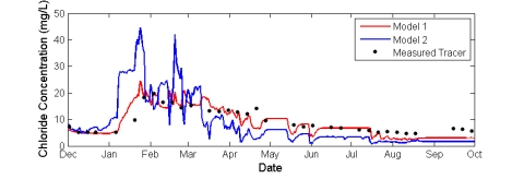
Figure 2. Two model simulations of the tracer Chloride concentration in the stream. Although these models produced almost identical simulation of river flow, Model 1 is much more successful than Model 2 at simulating the tracer.
A paper describing the design, building and testing of our water-tracking models has been published in the international journal Water Resources Research. Click here to view the paper.
Water mixing in a catchment
So far, our water tracking models assume that water in a particular part of the catchment (e.g. soil water) is 'completely mixed'. This implies that the chemical signatures are equalised over the whole storage volume. Our ongoing research asks, is that a good approximation in NZ catchments? Many previous field studies have investigated flow pathways in different catchments, and we reviewed them to give us clues as to how water mixes in those environments.
Our review showed that water mixing depends strongly on the landscape type. For example, on the West Coast, water mixes within the soil as it drains downwards towards the bedrock. Then, fast horizontal flow carries water over the bedrock surface towards the stream, often along cracks or spaces in the soil. There is little mixing during this fast flow (Graham et al., 2010). In contrast, research in small catchments in Otago showed that water was a mix of the very old (25 years or more) and very young (less than 1 year) (Stewart and Fahey, 2010). Some water drained vertically to join large groundwater reservoirs, while some travelled horizontally through moss or gravel layers to join valley bottom bogs (Bowden et al., 2001). Bogs and wetlands provide a place for surface and groundwaters to mix. In other catchments such as Moutere near Nelson, hydrologists observed sheets of surface flow during storm events, which flows direct to the stream with little mixing (Duncan, 1995).
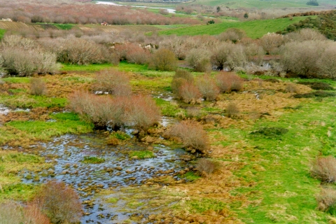
Figure 3: Wetlands in a catchment provide a place for surface and groundwaters to mix
All of these studies indicate a more complicated picture than the 'complete mixing' assumption. In future work, we will investigate how to include this knowledge of different mixing behaviour into our water-tracking models.
Future directions
In our future research, we will carry out surveys to find out how chemical signatures of streamwater, and so flow pathways, change over space and time during a storm event. This is part of NIWA's MSI-funded Waterscape programme, which aims to help scientists and resource managers get better understanding of New Zealand's combined surfacewater-groundwater resource. This project will also feed into NIWA's research into the transport of nutrients, contaminants and sediment through a catchment. These particles are often carried along with flowing water, and so can be tracked in similar ways.
References
Graham, C.B., Woods, R.A. and McDonnell, J.J., 2010. Hillslope threshold response to rainfall: (1) A field based forensic approach. Journal of Hydrology, 393(1-2): 65-76.
Bowden, W.B., Fahey, B.D., Ekanayake, J. and Murray, D.L., 2001. Hillslope and wetland hydrodynamics in a tussock grassland, South Island, New Zealand. Hydrological Processes, 15(10): 1707-1730.
Duncan, M.J., 1995. Hydrological impacts of converting pasture and gorse to pine plantation, and forest harvesting, Nelson, New Zealand. Journal of Hydrology (NZ) 34(1):15-41
Stewart, M.K. and Fahey, B.D., 2010. Runoff generating processes in adjacent tussock grassland and pine plantation catchments as indicated by mean transit time estimation using tritium. Hydrology and Earth System Sciences, 14(6): 1021-1032.