

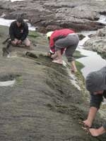
The coastal waters surrounding Te Māhia are subject to smothering plumes of sediment. Sheryl Miller, Murray Hicks, Mark Dickson, and Jarrod Walker discuss where the plumes come from and how they affect the region’s kaimoana.
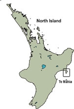
Tucked under East Cape, between Napier and Gisborne, Te Māhia (Mahia Peninsula) was once separate from New Zealand’s North Island, but over the last 10 000 years beach sand and dunes have linked the two. Pasture predominates and the remaining native coastal bush clings to steep, erodible cliffs. The northern end of Te Māhia is rapidly succumbing to coastal development, with subdivisions potentially increasing the amount of sediment washing into the sea. Plumes of sediment often extend from the mouths of freshwater streams, drains, and eroded cliffs, particularly after heavy rainfall. These sediment plumes occur regularly around much of the peninsula, muddying the water. Moreover, drapes of sediment (up to 2 cm thick) sit atop the mudstone reefs much of the time, blanketing the rocky reef habitat, smothering the species living in the intertidal zone and seabed, and hindering the local community from gathering kaimoana – food from the sea.
Where does the mud come from?
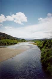
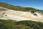
The sediment comes from local sources and from farther afield. Large volumes of sediment are delivered to the coast from the catchments along the east coast of the North Island. The catchment erosion rates are influenced by geology, tectonics, climate, and deforestation. Geology is a key factor, due to the prevalence of unstable and highly erodible mudstone and sandstone. Coastal erosion also contributes sediment, with cliffs retreating about 25 cm per year on average. At Te Māhia, some of the sediment comes from local catchments, more comes from erosion of the mudstone cliffs and tidal platforms that fringe the peninsula, while yet more drifts in with coastal currents. Depending on the current direction, these may bring mud south from the Waipaoa River or north from the Mohaka and Wairoa rivers. Coastal erosion is so severe in places that substantial areas of culturally significant land are being lost. For example, the community at Kaiuku marae have had to move the fence marking their seaward boundary four times over the last 10 years, and a statue on the marae grounds has been moved three times in the last 26 years.
Landuse is another important factor affecting the sediment supply. Before human settlement, Te Māhia was predominantly covered by mature indigenous forest, but since the 1880s much of this forest has been cleared for pasture. Consequently, without stabilising vegetation, large areas of steep hillslope have suffered severe slips. Harvesting of exotic forests and development of residential coastal properties, particularly subdivisions on hilltops, slopes, and ridgelines, at times have fed increased soil runoff into the surrounding coastal ecosystem.
Thus, while some sedimentation may be expected naturally from erosion of the soft mudstone and sandstone coast and hillslopes, human (or anthropogenic) activities at Te Māhia, and also those spread over the wider East Cape area, have all contributed to the currently observed high sediment accumulation rates in the estuarine and rocky coastal habitats there. This is a phenomenon seen worldwide. The effects of increasing sedimentation in the nearshore marine environment are well documented (see article by Airoldi in Further reading).
How does the mud affect kaimoana?
Customary harvest of kaimoana resources occurs regularly at Te Māhia, well known for recreational and commercial harvesting of lobsters, pāua (abalone), and kina (sea urchins). The effects of excessive sediment in the nearshore are wide-ranging and complex, including reduced settlement and survival rates of marine larvae, smothering or burial of immobile organisms, and reduced water clarity limiting the light necessary for photosynthesis. These may result in further cascading effects along the food chain, changing what species are found and type of habitat. For example, if kina larvae are reduced by sediment smothering, it affects not only the kina population in the area but also cultural and recreational harvesting. And, as kina are an important component of their diet, lobster may move further offshore to forage.
What can be done about it?
The Wairoa District Council recognises the need for environmental protection and for mitigating the effects of coastal development, and has adopted a list of actions to be undertaken over the next 20 years. These measures will enhance the landscape through reforestation, restoration, and riparian planting.
An earlier article in Water & Atmosphere describes the voluntary rāhui already in place around the peninsula. These bans on collecting kaimoana provide some protection against over-harvesting by closing the area to commercial fishing (except for lobster).
Members of the Māhia Coastal Marine Strategy (MCMS) monitor three species that live in the rocky reefs surrounding Te Māhia: pāua, kina, and lobster. In order to assess the impact the nuisance sediment is having on these kaimoana resources, and additional seaweed species such as karengo, NIWA and the MCMS group will set up permanent monitoring sites inside and outside the rāhui boundary. We will measure sediment cover as well as environmental variables, such as substrate type, water clarity, and depth, on a seasonal or bi-monthly basis to identify patterns in distribution and abundance of selected species. This research will enable robust conclusions regarding the progress and validity of using management techniques such as rāhui.
Ultimately, our research on the effects of sedimentation and the effectiveness of rāhui should complement customary knowledge and practices. Our goal is to determine the best methods of protecting an area while enhancing the ability of local communities to manage their kaimoana resources.
Clearing the waters
- Local geology, extreme events, and modern development all contribute to sediment plumes in coastal waters around Te Māhia.
- The clouds of fine sediment around the coast can hinder the customary gathering of kaimoana.
- Research to monitor sediment accumulation and its effect on particular species aims to help preserve kaimoana resources.
Events contributing to the muddy waters around Te Māhia
- The Hawkes Bay earthquake of 1931 (magnitude 7.8) caused numerous landslides, cracks, and fissures.
- An extreme storm in 1938 was the first large rainfall since land was converted to pasture. Aerial survey photos from the 1940s show sediment discharge plumes, indicating muddywaters are a long-term problem.
- Cyclone Bola in 1988 had a devastating impact on the area, with long-lasting consequences. Sediment concentrations in the catchments remained elevated for several years.
Further reading and useful links
Airoldi, L. (2003). The effects of sedimentation on rocky coast assemblages. Oceanography and Marine Biology: an Annual Review 41: 161–236.
Miller, S.; Ormond, G. (2007). A gift from the sea: managing kaimoana resources. Water & Atmosphere 15(2): 14–15.
Wairoa District Council website:
- Māhia Isthmus Communities Structure Plan: www.wairoadc.govt.nz/consultation/mahiaisthmus
- Wairoa Coastal Strategy: www.wairoadc.govt.nz/planspolicy/coastal
- Māhia Beach Township Structure Plan: www.wairoadc.govt.nz/planspolicy/mbtsp
Dr Sheryl Miller (Ngāi Tahu, Kāti Mamoe, Waitaha) is a member of Te Kūwaha o Taihoro Nukurangi (NIWA’s Māori Research & Development Group), based in Wellington. Dr Murray Hicks and Dr Mark Dickson are based at NIWA in Christchurch; their research interests include coastal process and sedimentation. Dr Jarrod Walker works in fisheries and marine ecology at NIWA in Auckland.
Teachers’ resource for NCEA Achievement Standards or Unit Standards: Biology Level 2 AS90769, AS90461 Geography Level 2 AS90331, US5089, Level 3 AS90701, US5095
