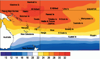
Climate developments in September 2006

During September, convection associated with the SPCZ was near normal. There were weak regions of enhanced convection over Papua New Guinea, parts of Western Kiribati, Wallis and Futuna, and Samoa. There no significant areas of suppressed convection.
High September rainfall occurred in parts of the Tuamotu Islands (429% of normal) of French Polynesia, and parts of Fiji. Wet conditions also persisted over parts of Samoa and Tonga, where rainfall was 130 to 160% of average. Rainfall was 50% or less of average in parts of New Caledonia, Rikitea (French Polynesia) and parts of Tonga. Below average rainfall was also recorded in Niue.
Mean air temperatures were 0.5°C or more below average in parts of New Caledonia, and the Southern Cook Islands.
Tropical Southwest Pacific mean sea-level pressures were above average over much of Australia, the Tasman Sea, and well east of New Zealand, along latitude 35° S. They were below average in tropical areas near the equator east of the Date Line.
Equatorial surface westerlies occurred in about 25% of observations at Tarawa, a slight decrease in frequency from almost 30% during August 2006.
| Country | Location | Rainfall (mm) | % of average | Comments |
|---|---|---|---|---|
| French Polynesia | Tuamotu, Takaroa | 351.6 | 429 | Record high |
| Fiji | Nausori | 328.9 | 199 | Extremely high |
| Tonga | Queen Lavinia | 43.5 | 30 | Low |
| Tonga | Lupelau’u | 42.9 | 32 | Low |
Soil moisture in September 2006

Estimates of soil moisture shown in the map (above) are based on monthly rainfall for one station in each country. Currently there are not many sites in the water balance model. It is planned to include more stations in the future.
The information displayed is based on a simple water balance technique to determine soil moisture levels. Addition of moisture to available water already in the soil comes from rainfall with losses via evapotranspiration. Monthly rainfall and evapotranspiration are used to determine the soil moisture level and its changes.
Please note that these soil moisture calculations are made at the end of the month. For practical purposes, generalisations were made about the available water capacity of the soils at each site.
At the end of September 2006, Apia, Hanan Airport, Fua’motu and Rarotonga were at field capacity (full). Nadi soil moisture levels were dry.
El Niño/Southern Oscillation (ENSO)


The tropical Pacific currently shows a pattern consistent with El Niño conditions.
There has been continued warming in the upper layers of the Equatorial Pacific Ocean during the past three months. As of mid-September sea surface temperatures (SSTs) exceed 0.5°C above average throughout much of the equatorial Pacific and are more than +1°C above-average near the date Line.
The NINO3 SST anomaly for September was around +1.2°C (+0.8°C for July–September) and NINO4 was around +1.2°C (+0.9°C for July–September). This is a significant increase from last month.
Subsurface temperatures show a more coherent structure of warm anomalies than last month.
Although the Southern Oscillation Index (SOI) has weakened in the last 30 days it continues to remain negative (now five consecutive months) with a value of –0.5 for September, and -1.1 for July–September. Given the increase in NINO3 and NINO4 SSTs, the weakening of the SOI is likely to be a temporary situation.
There have been reduced westerly wind anomalies along the equator in September and west of the Date Line, which contrasts with July and August. OLR anomalies continue to show a dipole pattern, however, this has drifted somewhat westwards in September: positive (i.e. drier) anomalies exist from the western Indian Ocean to Indonesia and negative (wetter) anomalies over Papua New Guinea. In contrast, the Madden–Julian Oscillation (MJO) has been more active during September and is forecast to strengthen over next few weeks.
More than half of the statistical and coupled model predictions are now favoring El Niño conditions for the remainder of 2006 and through the southern hemispheric summer.
The International Research Insitute for Climate and Society (IRI) (who have a higher threshold for an El Niño) indicate that El Niño conditions, in terms of tropical Pacific SST anomalies, have been crossed recently. Some caution remains however over whether the current climate patterns across the equatorial Pacific constitute a basin-wide El Niño event.
The World Meteorological Organisation (WMO) (September 26) cautiously states "the situation is expected to become clearer in the next 1-2 months", while reminding that there is still a small possibility that the event could also dissipate in the next couple of months.
The WMO statement continues that the development of a basin-wide El Niño event is likely based on the prevailing situation and the general consistency of forecast models.
Furthermore, once El Niño conditions are established at this time of the year, they almost always persist until early the following year.
