2004-05 Tropical Cyclone Season Summary
Stuart Burgess, NIWA


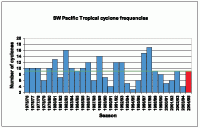
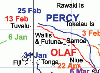
The 2004-05 Southwest Pacific tropical cyclone season had nine occurrences (east of 150° E), the same as the average number normally expected for the region in a season (see Figure 1). About half reached major hurricane strength, with sustained wind speeds of at least 168 km/h. All but one of the Southwest Pacific tropical cyclones (the tracks of which are shown in Figure 2) originated east of the Date Line and all occurred within the December to April period. This was compatible with the ICU forecast issued in November 2004 for more tropical cyclones than normal for the season, near and east of the Date Line.
The most devastating tropical cyclones of the 2004-05 season were Meena, Nancy, Olaf, and Percy, all occurring in February. Most were triggered by an active phase of the Madden-Julian Oscillation which moved across the Southwest Pacific.
Judy was the first tropical cyclone of the season (named on Christmas Day) and brought torrential rainfall to parts of the Tuamotu Islands of French Polynesia.
Kerry developed northeast of Vanuatu on 6 January, passing over the Pentecost and Malekula Islands the next day, with pressures as low as 987 hPa, and maximum sustained wind speeds of 167 km/h.
Lola affected the region near Tonga from 31 January through 2 February, with strong winds at Fua'amotu Airport.
Meena, was east of Samoa on 3 February and tracked towards the Southern Cook Islands. Estimated maximum sustained wind speeds reached 232 km/h, with gusts to 287 km/h. Storm force winds occurred at Mauke on 6 February, with pressures as low as 986 hPa. Gale force winds and gusts to 115 km/h occurred in Rarotonga on the same day, preceded by heavy rainfall totalling about 100 mm.
Nancy affected the Northern Cook Islands from 13 to 15 February tracking south, Aitutaki residents stocking up on emergency supplies and tourists evacuating resorts over 15-16 February. Estimated sustained maximum winds reached 232 km/h. Storm force winds gusted to 163 km/h in Rarotonga, with reports to 185 km/h elsewhere, preceded by heavy rainfall, pressures as low as 988 hPa, and huge seas. In Aitutaki, trees were uprooted, roofs damaged, and low lying areas flooded. Waves caused widespread destruction along the northern and eastern coasts of Rarotonga. The island of Mangaia was also badly hit.
Olaf was named on 13 February, with maximum sustained winds near its centre later reaching 269 km/h. Winds exceeded 120 km/h in Samoa on 16 February, with roofing iron lifted. Both nations declared a state of emergency. Gales buffeted the Northern and Southern Cook Islands on 17 February (with gusts to 95 km/h in Rarotonga), residents stocking up on emergency supplies and tourists evacuating resorts beforehand.
Percy was also destructive, with maximum sustained winds reaching 260 km/h. Gales, storm surge, and high tides affected Tokelau on 26 February, where it was said to be the worst tropical cyclone in living memory. Several homes were damaged and roads scoured, with water up to 1 m deep breaking over the sea wall to reach some areas.
Rae followed (near the Southern Cook Islands) on 6 March, but was weak.
Ingrid, which formed on 6 March in the Australian region (west of 150° E), was quite intense, forming in the Coral Sea south of Papua New Guinea, and then tracking west over Queensland and the Gulf of Carpentaria.
Sheila formed east of Niue on 22 April, and tracked southeast, with maximum sustained winds reaching 65 km/h.
