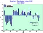
Southern Oscillation Index (SOI) adopted from Bureau of Meteorology, Australia. Click to enlarge

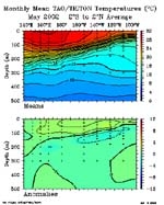
Sub Surface Temperature along the Equator for May 2002 (adapted from TOA/TRITON). Click to enlarge

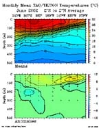
Sub Surface Temperature along the Equator for June 2002 (adapted from TOA/TRITON). Click to enlarge
El Niño Update
More progress towards the evolution of an El Niño in the last month
Probabilities have increased to 85% for an El Niño event affecting the whole of the Southwest Pacific by September this year. Most of the key indicators such as the warm Sea Surface Temperatures (SSTs) in the Central Equatorial Pacific and further westerly wind bursts have progressed towards conditions that lead to the evolution of an El Niño event. The outlook guidance indicates there has been significant warming in the Equatorial Pacific, where SSTs are more than 1°C above normal. The 3-month value of the Southern Oscillation Index (SOI) is now -0.8, the lowest since the last El Niño event, increasing the chances of an ENSO event.
Present situation and outlook
Historically this is the period of the year when transitions to an El Niño event can occur. However, in certain events September-October was also favoured as the transitional time toward ENSO events. Continuing evidence suggests that the chances of an El Niño this year have increased considerably since May 2002.
The evidence for a developing El Niño event which is expected to influence much of the Pacific climate by September 2002, continues to strengthen, though the magnitude of the coming event remains uncertain. Monitoring of the climatic conditions in the Pacific Ocean is important due to uncertainty of the magnitude of this evolving El Niño.
Considerable parts of the equatorial Pacific Ocean remain more than 1°C warmer than normal. If the SSTs continue to warm, 2002 could be called an El Niño year. The NINO3 and NINO4 region SST anomalies have increased with some areas being at least 0.5°C to 1°C above normal.
The evidence of the evolution of an El Niño continues to strengthen, as the SOI (Fig. 1) remains negative (-6.3, Australian SOI ) with increased cloudiness in the central Pacific and weakening of the South Pacific Convergence Zone (SPCZ). The trade winds have also weakened.
The June OLR data showed a decrease in convection over Northern Australia and around the date line at 15°S – 20°S.
During June, the SPCZ weakened and moved northwards towards equatorial regions resulting in drying in parts of the South West Pacific. There was also enhanced convective activity over the Eastern Tropical Pacific.
The sub-surface temperature data for equatorial Pacific showed a significant expansion of positive anomalies (red) in the Eastern Pacific (Fig. 2). The weakening trade winds across Pacific contributed to this warming in the Eastern Pacific.
Although most of the Global Climate Models were not predicting an El Niño in the last two months, 8 out of 11 models are now predicting El Niño by late 2002 or early 2003.
