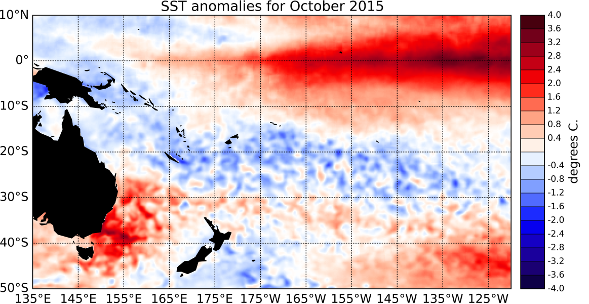
Strong El Niño conditions continued in October 2015. Sea surface temperature (SST) anomalies in the central and eastern Pacific have increased since September and are close to or exceed +2.5°C in places. Sub-surface ocean temperatures in the eastern Pacific are at similar levels too September and exceed +6°C off the South American coast (east of about 120°W and at about 75 – 100m depth). The atmosphere is well coupled to these ocean anomalies.
The Southern Oscillation Index (SOI) was strongly negative (-2.1 for October 2015). Westerly wind anomalies (implying weaker easterly trade-winds) have intensified further since September and moved further east to straddle the International Dateline. Consistent with these patterns, convection and rainfall was suppressed over Indonesia and large parts of the Maritime Continent, while enhanced convective activity and rainfall were observed in the central and eastern Equatorial Pacific.
The South Pacific Convergence Zone (SPCZ) was again this month mostly suppressed in the southwest Pacific, and shifted towards the Equator in the central Pacific. The Inter-Tropical Convergence Zone (ITCZ) was displaced towards the Equator in the eastern and central Pacific and suppressed in the western Equatorial Pacific. The ENSO Precipitation Index (ESPI) reflects strong El Niño conditions with a value of +1.64 (value to the 4th of November 2015).
The Madden-Julian Oscillation (MJO) was mostly inactive over the western Pacific during the past two weeks. At the forecast horizon of 14 days, the dynamical and statistical CPC forecasts diverge: the dynamical forecasts indicate a progressive in-place weakening of the region of high convective activity currently present in the Indian Ocean, while the statistical forecast has it propagating into the Maritime Continent. International guidance indicates that El Niño conditions are certain (100% chance) to continue over the next three month period (November 2015 – January 2016) and through to the summer (January – March 2016).

