Tropical rainfall and SST outlook: May to July 2009


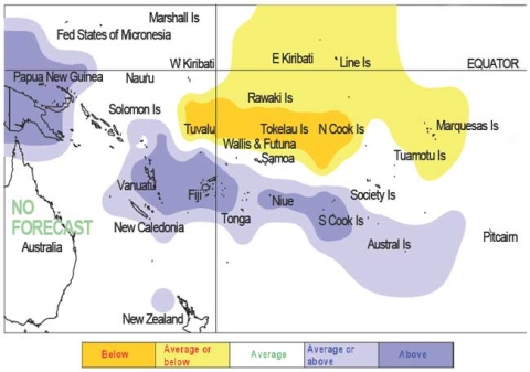
During May – July 2009, a region of suppressed convection is likely in the southwest Pacific encompassing Tokelau, Tuvalu, and the Northern Cook Islands, with below average rainfall expected for those areas. Near to below average rainfall is expected for Eastern Kiribati and the Marquesas. Near normal rainfall is forecast for Pitcairn Island and Samoa. Enhanced convection is likely in the area around Papua New Guinea and Vanuatu, Fiji, Niue, and the Southern Cook Islands, with above average rainfall anticipated for the coming three month period. New Caledonia, Tonga, Wallis & Futuna, and the Austral Islands are expected to receive near or above average rainfall. No clear precipitation guidance is offered for the Western Kiribati, the Solomon Islands, the Tuamotu Archepelago and the Society Islands.
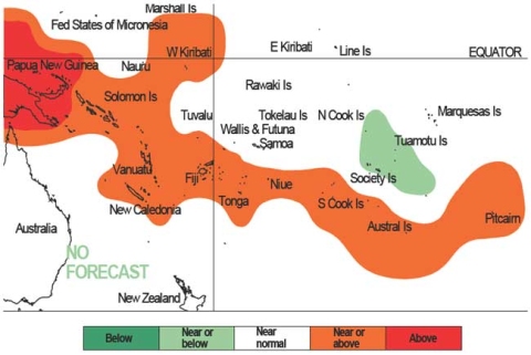
Prominent SST anomalies that existed in the region during that past months are now easing. Global models indicate significant shifts to near-neutral SSTs during Austral winter, but lingering anomalies related to the past La Nina event may exist. Above average SSTs are expected for Papua New Guinea, and near or above average SSTs are forecast for Western Kiribati, the Solomon Islands, Vanuatu, Fiji, Niue, New Caledonia, Tonga, Samoa, Niue, the Southern Cook Islands, the Austral Islands, and Pitcairn Island. Near normal SSTs are forecast for Samoa, Tokelau, Tuvalu, the Northern Cook Islands, Wallis and Futuna, and the Society Islands. Average to below average SSTs are expected for the Tuamotu Archipelago. No clear SST guidance is provided for the Marquesas or Eastern Kiribati.
The confidence in the multi-model ensemble forecast skill for this seasonal rainfall outlook is moderately high for most Pacific Island countries. In the past, the average region-wide hit rate for rainfall forecasts issued in May is 53%, 8% lower than the long-term average for all months combined. The SST forecast confidence is moderate–to–high for this period.
|
|
NOTE: Rainfall estimates for Pacific Islands for the next three months are given in the table. The tercile probabilities (e.g., 20:30:50) are derived from the interpretation of several global climate models. They correspond to the odds of the observed rainfall being in the lowest (driest) one third of the rainfall distribution, the middle one third, or the highest (wettest) one third of the distribution. On the long-term average, rainfall is equally likely (33% chance) in any tercile.
