Climate developments in April 2009

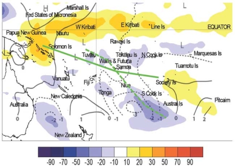
The South Pacific Convergence Zone (SPCZ) shifted east during April, with the northwestern part of the convective spur moving northeast of normal. However the southeastern portion of the SPCZ remained displaced southwest of its normal position for the month, contributing to high rainfall in the Austral Islands. A region of enhanced rainfall, partly due to intensified convection, was also observed in the north Tasman Sea and near New Caledonia last month. Suppressed convection intensified near the Solomon Islands during April and persisted in a zone including Western Kiribati, Nauru, and Eastern Kiribati. There was also suppressed convection localised near the Pitcairn Islands and Society Islands. The regional circulation in April was characterised by more frequent low pressure in the North Tasman Sea and to the northeast of New Zealand, over the Austral Islands.
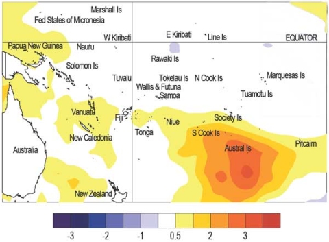
There were not many high precipitation totals concentrated in any particular island group in the southwest Pacific during April. In French Polynesia dry conditions occurred over Tuamotu, Gambier, and the Society Islands, which also experienced above normal pressures for the month. A record daily maximum temperature was also recorded at Rapa (30.3°C), located at the southeastern end of the Austral Islands. Nearby in the Southern Cook Islands, near normal rainfall occurred at Rarotonga. Most stations in Fiji were normal or below normal for rainfall during April, the exception being Ono–i–lau which received 403mm of rainfall (257% of normal). Western Kiribati continued to have dry conditions, and Butaritari, Tarawa, and Kanton all had below normal rainfall during April.
There were also some localised high rainfall totals in the central and southeastern parts of the southwest Pacific. Northern New Zealand experienced a relatively dry month, but the Far North of the country recorded well above normal normal rainfall (257% of normal). Wallis and Futuna also reported very high rainfall totals during April (see table below). Lord Howe Island was one exception for month, recording 515mm of rainfall (318% of normal) that was the result of a sub-tropical low. In Tonga, nearly 200% of normal rainfall fell at Lupepau’u. Monthly rainfall totals were also well above normal in Tuvalu, which had 140 – 190% of normal recorded at Nui and Funafuti, respectively. 610mm of rain (263% of normal) fell at Rapa in the Austral Islands, which was the second highest amount reported in the region last month. The high rainfall totals for these two island groups was the result of SPCZ activity during April.
| Island Group | Location | Rainfall (mm) | % of average | Comments |
|---|---|---|---|---|
| Wallis | Wallis Island | 572 | 233 | Record high |
| Futuna | Maopoopo | 746 | 225 | Highest monthly total in the region |
| Tonga | Lupepau'u | 413 | 198 | High |
| Tuvalu | Nui Island | 478 | 199 | High |
| North Tasman | Lord Howe Island | 515 | 318 | High |
| Austral Islands | Rapa | 610 | 263 | High |
Soil moisture in April 2009

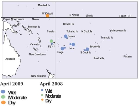
Estimates of soil moisture shown in the map (right) are based on monthly rainfall for one station in each country. Currently there are not many sites in the water balance model, but it is planned to include more stations in the future.
The information displayed is based on a simple water balance technique to determine soil moisture levels. Addition of moisture to available water already in the soil comes from rainfall, and losses via evapotranspiration. Monthly rainfall and evapotranspiration are used to determine the soil moisture level and its changes. Please note that these soil moisture calculations were made at the end of the month, and for practical purposes, generalisations were made about the available water capacity of the soils at each site.
Hanan (Niue), Rarotonga (Southern Cook Islands), Apia (Samoa) and Fua’amotu (Tonga) project moist (at or near field capacity) soil moisture conditions. Soils are moderate for the time of year at Nadi (Fiji), and dry at Tarawa (Kiribati).
El Niño/Southern Oscillation (ENSO)


During April, the equatorial Pacific Ocean returned to ENSO-neutral conditions, after exhibiting a La Niña state since December 2008. NINO3 and NINO4 SST anomalies are now close to zero: +0.1°C and –0.1°C respectively (February – April means both around –0.4°C). Sea surface height anomalies still remain positive in the western Pacific, but show a north–south banded structure in the east, with positive anomalies along the Equator east of the Date Line.
Equatorial subsurface ocean temperature anomalies are now positive in the uppermost 100m near the South American coast, as well as in the uppermost 200m west of the Date Line.The easterly trade winds strengthened in April, west of the Date Line, but eased late in the month, with westerly anomalies evident at the end of April. Consistent with this, the TRMM ENSO precipitation index strengthened to –1.8 in April. However, tropical Pacific convection/OLR does not exhibit a clear La Niña pattern, though convection is suppressed near the Equator, east of 150°E.
The MJO was active in April, with an event propagating steadily across the Maritime Continent and the western Pacific in the last two weeks of the month. This presumably contributed to the strengthening of the SOI, which rose again in April to +1.0, after falling to –0.2 in March (February – April mean was +0.7). The MJO is expected to weaken over the coming weeks.
The global climate model ensemble assessed by NIWA indicate neutral conditions on average will prevail during May – July. Almost all models show warming over the next few months, with three suggesting El Niño conditions later in 2009. The NCEP discussion of 9 April suggests a transition to neutral conditions during May, with La Niña-like impacts lingering through June. The IRI summary of 15 April indicates a 75% chance of neutral conditions persisting through to June and remaining the most likely ENSO state for the rest of 2009.
Tropical Cyclone Activity and Guidance
Only one Tropical Cyclone (TC) formed in the Southwest Pacific region during April. TC Lin formed on 4 April east of Fiji and moved towards Tonga, passing over Tongatapu on 5 April. Sustained winds for TC Lin were estimated to be 55 knots with gusts up to 80 knots close to the storm centre. One significant tropical depression also occurred near Lord Howe Island, and was active from 16-25 April. This system reached a Category One status on 19 April as it passed over the island, with maximum wind gusts of 149km/h recorded at that time. A one day rainfall total of 230mm from this storm was recorded on 20 April.
Forecast validation: February to April 2009
A region of suppressed convection was forecast to encompass the central and eastern Southwest Pacific, extending to the southeast from Western Kiribati and including Tuvalu, Tokelau, the Northern Cook Islands, and the Society Islands, where below normal rainfall is expected. Near–to–below normal rainfall was expected for Samoa, Eastern Kiribati, the Tuamotu archipelago, and the Marquesas Islands. Enhanced convection was expected to extend southeast from, Papua New Guinea, and include New Caledonia, Tonga and Niue, where above normal rainfall was expected. Near or above normal rainfall was forecast for the Austral Islands, Fiji, the Southern Cook Islands, and Pitcairn Island. No clear precipitation guidance was offered for the Solomon Islands or Wallis & Futuna for the three-month forecast period.
The February – April 2009 forecast validation was calculated for 15 island groups (three countries did not report rainfall values; two were forecast as climatology and were unscorable). The global island group ‘hit’ rate was 85%, 22% higher than average, and 24% higher than the average for all months combined. Rainfall was overprojected for Tonga.
