PDF of this article (358 KB)

David Kelly, Alistair McKerchar, and Murray Hicks have combined biological and sedimentological data to form a picture of downstream effects.


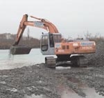
Binding gravel together with cement makes concrete, the country’s most widely used construction material. Gravel-bed rivers close to urban areas are ideal sources of material for concrete and roading aggregates. River engineers manage extraction rates to maintain the flood capacity of channels by seeking a balance between extraction rates and the naturally occurring gravel supply from catchment headwaters. Over-extraction of river gravels can lower the riverbed, change the channel profile, and alter riverbed sediment composition. The resulting changes in river sediments and channel hydraulics could have significant effects on communities of benthic invertebrates, small creatures living within the gravel, and fish. Farther downstream, reduced gravel supplies to the coast can upset the stability of river mouth lagoons and can accelerate coastal erosion.
Where and how much?
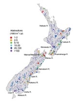
As a first step in understanding the potential effects of gravel extraction, we compiled information on the rates of gravel extraction from rivers throughout New Zealand. Most extraction takes place close to population centres from larger rivers draining catchments where greywacke rock forms the dominant lithology. For example, virtually no extraction occurs in Taranaki, or in the Waikato and northwards, apart from some limited amounts in the Coromandel and Northland and some Waikato River sand. In the South Island, little is taken from west coast rivers, although the quantities available are large. Where handy alluvial gravel supplies are absent or limited, such as around Auckland, Hamilton, New Plymouth, Tauranga, and Dunedin, aggregates are supplied by hard-rock quarrying.
Rivers around Nelson and in Southland have limited gravel-supply rates and past extraction rates have far exceeded the supply rates. In Southland, lowering of the Oreti River bed has caused concern about bridge pier stability, and gravel is now taken by excavating lagoons alongside the active river channel. These lagoons become attractive fish and wild fowl habitats. On the Mataura River, rated the country’s best river for trout fishing, extraction has ceased downstream of Gore and is limited upstream.
What are the environmental effects?
We focused our study on the Kakanui River near Oamaru in Otago and the Waimea River and its tributary the Wairoa River (hereafter referred to as Wairoa) near Nelson in the Tasman District because they differ in both their rates of gravel extraction and their predicted rates of gravel supply. Gravel supply in rivers is dependent upon the catchment area, topography, lithology, and rainfall. The Kakanui River catchment is less steep, has lower annual runoff, and less hydrological variability (see table below); so we would expect the amount of gravel supplied to the coastal floodplain where gravel is harvested to be smaller than for the Wairoa River. However, the current rate of extraction for the Kakanui River is more than four times that in the Wairoa – 32,000 m3 annually versus only 7000 m3 for the Wairoa. Historically, harvesting rates were greater for the Wairoa; however, downstream degradation of the riverbed caused undermining of bridge pilings, and harvesting rates were reduced to prevent further degradation.

What have the differences in harvesting rates versus gravel supply meant for in-stream habitats and communities in these two rivers? For the Kakanui, we observed significant differences in channel morphology, substrate composition, and river hydraulics in the immediate area of gravel harvesting (on-site) and downstream compared with upstream reaches. The channel became narrower and more incised, the riverbed substrate was finer with more silt, sand, and exposed bedrock, and water velocities near the riverbed were higher and more uniform spatially. Gravel tends to move downstream in pulses during freshes and floods (see “A bird’s eye assessment of gravel movement in large braided rivers”). Gravel harvesting in the Kakanui appears to have starved downstream reaches of gravel supply, thereby degrading the channel, fining the substrate, and exposing bedrock. Some of these same trends were apparent in the Wairoa River, but to a much lesser degree. The most obvious trend was diminished grain size of bed material downstream, whereas channel cross-section profiles and near-bed water velocities were relatively unchanged, and there was no increase in exposed bedrock.
The diversity of invertebrate communities in flowing waters is partly a function of the heterogeneity of habitats along the riverbed. Larger, more heterogeneous bed materials increase the diversity of microhabitats, such as eddies and depositional zones, that are used by colonising invertebrates and fish. Conversely, channels lined by fine-grained substrates and sometimes by bedrock are less rough, and flows near the riverbed are more uniform, providing biota little refuge from strong river currents. Larger substrate is also more stable, providing protection for biota during high-flow events.
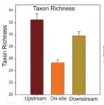
In the Kakanui River, downstream changes towards finer bed materials overlaying exposed bedrock (as much as 73% of the riverbed for some downstream reaches) increased the stream velocities near the riverbed while decreasing flow heterogeneity. There was a concurrent decline in total invertebrate abundance, taxon richness, and percent composition by sensitive taxa such as mayflies, stoneflies and caddisflies (%EPT – a standard measure of diversity; see “Classifying stream invertebrate communities”). Conversely, in the Wairoa River, where downstream changes in substrate and river hydraulics were less severe, declines in total invertebrate abundance were only minor. Taxon richness, however, was markedly lower both on-site and downstream of the gravel extraction operations in the Wairoa. This may indicate that substrate size is a particularly important factor driving invertebrate species richness, as this was the main physical habitat feature that changed downstream of gravel harvesting areas.
Implications for management: how much is too much?
Our study on quantifying the effects of gravel extraction on in-stream habitats and communities demonstrates that gravel harvesting can trigger severe physical and biological changes. In particular, decreases in habitat diversity, expressed through changes in riverbed substrates and hydraulics, can reduce benthic community diversity and abundance. These changes would undoubtedly have profound consequences for other biota, such as fish, and could warrant future investigation.
Balancing gravel-harvesting quota licences with sediment transport rates must be the aim for minimising effects. Even relatively small changes in riverbed substrate and habitat heterogeneity appear to be very important for benthic communities. There is also very limited information on gravel supply rates in New Zealand rivers. Adaptive management strategies that regularly survey physical habitats, channel profiles, substrate, and biological communities downstream from activities in the active river channel may be the answer to minimising effects on a long-term basis.
| Kakanui River – Otago | Wairoa / Waimea River – Tasman | |||||
|---|---|---|---|---|---|---|
| Gravel harvest rate (1000 m3/yr) | 32 | 7 | ||||
| Catchment area (km2) | 665 | 707 | ||||
| Lithology | schist / sedimentary | greywacke / argillite | ||||
| Mean annual runoff (mm/yr) | 320 | 1140 | ||||
| Mean annual flood (m3/s) | 284 | 710 | ||||
| Benthic habitat characteristic | Up-stream | On-site | Down-stream | Up-stream | On-site | Down-stream |
| Wetted channel width (m) | 10 | 6 | 8 | 38 | 38 | 37 |
| Mean depth (cm) | 22 | 23 | 24 | 43 | 38 | 43 |
| Substrate size (mm) | 119 | 62 | 59 | 86 | 75 | 40 |
| Substrate heterogeneity | 1.0 | 1.0 | 0.9 | 1.6 | 1.4 | 1.2 |
| % exposed bedrock | 0 | 12 | 36 | 1 | 0 | 0 |
| Near-bed velocity (cm/s) | 16 | 30 | 40 | 28 | 34 | 30 |
| Index flow heterogeneity | 2.6 | 1.8 | 2.0 | 1.8 | 1.6 | 1.7 |
| Fines (g/L substrate) | 34 | 150 | 120 | 230 | 280 | 270 |
The authors are all based at NIWA in Christchurch. Dr David Kelly is a benthic ecologist working on aquatic foodwebs, and Dr Alistair McKerchar and Dr Murray Hicks work on sediment processes.
Teachers’ resource for NCEA AS: Biology 2.5; Geography 3.1. See other curriculum connections at www.niwa.co.nz/pubs/wa/resources
