PDF of this article (247 KB)
Taxonomy training with an expert
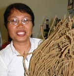
Belinda Longakit arrived in Auckland in September 2004 to work for two months with Dr Michelle Kelly, the sponge expert with NIWA’s National Centre for Aquatic Biodiversity & Biosecurity. Belinda, who is from Cebu in the Philippines, came over for some intensive training in sponge taxonomy so that she could complete her MSc in Marine Biology at the University of San Carlos. In her working life, Belinda is a fisheries training specialist with the Cebu State College of Science and Technology.
Prompted by the difficulty of sponge taxonomy and the shortage of expertise in the Philippines, Belinda searched the Internet for help. There she found Michelle, who outlined a training programme. It took Belinda a further two years to get the funding, which came courtesy of the PADI Foundation, USA.
The model for training was very successful, as it allowed Michelle to keep up her busy schedule of sponge identifications while also supervising her student. Belinda prepared her sponge material under Michelle’s guidance and used the extensive resources in the Sponge Lab to complete preliminary identifications. She was further integrated into NIWA’s Auckland office by making her temporary home in New Zealand with Beverley Wilson, the office administrator.
Belinda says of her training experience, ‘With the many people involved in my training on sponge taxonomy, I feel greatly indebted, and my only way of repaying this debt is to promote and create opportunities for other students back in my country to work on these often neglected marine organisms. My two months training at NIWA has not only taught me the ABCs of sponge taxonomy but also served as an eye-opener on the opportunities that could be generated from this valuable marine resource.’
For further information, contact: Dr Michelle Kelly, 0-9-375 2037, [email protected]
Measuring trace-gas concentrations at White Island
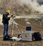
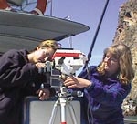
During October 2004, NIWA organised a campaign to measure gaseous emissions from New Zealand’s only year-round active volcano, situated on White Island. We used a small, portable spectrograph, designed to measure the spatial distribution of trace gases in the atmosphere. Such optical remote-sensing methods are ideal for studying volcanic emissions while minimising the risk to the observer. Emissions of volcanic gases usually precede volcanic eruptions, providing a warning signal and an indication of the nature of the lava. Volcanic emissions are also a significant source of gases and particles to the atmosphere. Explosive volcanoes can even inject gases and particles into the stratosphere, where they can affect ozone.
The Institute of Geological and Nuclear Sciences (GNS) regularly monitors sulphur dioxide (SO2) emissions from the White Island volcano, but measurements of other gases, such as bromine oxide (BrO), provide additional information which can be used to infer changes in the state of the volcano. The goal of our campaign was to see if BrO could be detected in the volcano’s plume and, if so, to measure the ratio of the BrO and SO2 concentrations. The only previous measurements of BrO and SO2 were made in the plume of the Soufriere Hills volcano (Montserrat) in May 2002 using an instrument similar to the one used here.
The first day of the campaign was spent on the island itself. The only way we could get there was to join a tour group run by a licensed operator (White Island Tours, Whakatane). While the tourists enjoyed a guided tour of about two hours on the island, we set up our instrumentation close to one of the main vents. We took as many measurements as possible in the limited time available to us.
In an effort to measure several cross-sections of the plume, we spent the following two days on board a small vessel (run by Dolphins Down Under), cruising past the island underneath the plume. This was a challenging task because the plume was invisible. Working from the boat allowed us to spend more time making observations, but with the risk that we might be missing the plume. Our initial results, however, show clearly that we were looking through the volcanic plume as planned. We are now finalising the results of our BrO and SO2 observations of the White Island volcanic plume.
For further information, contact Karin Kreher, 03 440 0447, [email protected]
Advancing international biodiversity initiatives
As signalled in our special Biodiversity & Biosecurity issue, NIWA has been involved in coordinating regional activities to further global biodiversity goals.
In October, NIWA organised the 2nd Regional GTI Workshop in Asia-Oceania. The GTI (Global Taxonomy Initiative) is an innovative plan developed by the Parties to the Convention on Biological Diversity to promote taxonomic information by bringing together funding agencies, governments, and NGOs. The immediate outcome of the October workshop was four large and several smaller research proposals, some to be advanced for funding by the Global Environment Facility. Those projects involving Pacific Island states will be useful to the NZ/SW Pacific OBIS Node to be based at NIWA.
Another activity is the ‘Species 2000: New Zealand’ review and inventory of New Zealand’s entire biota, a regional contribution to Species 2000 Global Species Databases (GSDs). NIWA coordinator of these activities, Dr Dennis Gordon, also serves on the international Species 2000 Taxonomy Group as advisor on marine invertebrates. This group will be meeting in Malta in March to advance the achievement of further GSDs. While there, Dennis will also address the co-convening Species 2000 Europa group on strategy and progress of the New Zealand regional activity.
For further information, contact: Dennis Gordon, 0-4-386 0388, [email protected]
GTI – Global Taxonomy Initiative: www.biodiv.org/programmes/cross-cutting/taxonomy/ CBD – Convention on Biological Diversity: www.biodiv.org OBIS – Ocean Biogeographic Information System: www.iobis.org Species 2000 – www.species2000.org
First anniversary of the February floods
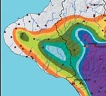
Since the floods of 2004 that devasted the lower North Island, NIWA has worked behind the scenes to help regional councils, insurance companies, and others better prepare for and respond to flooding.
One research focus has been to estimate the likelihood of a flood event of that magnitude occuring again. How rare was the February storm? NIWA has produced maps of the average recurrence interval of the maximum amounts of rain which fell in a 12-hour, 24-hour, and 48-hour period during the storm. The maps show that, over large parts of the region, the heaviest rainfalls during the storm have recurrence intervals of more than 150 years. It was indeed an extraordinary event.
We use our HIRDS (High Intensity Rainfall Design System) software to estimate the average recurrence intervals (or return periods). HIRDS can estimate the frequency, depth, and duration of rainfall at any point in the country. It can help city and district council planners and engineers to determine the intensity of downpours with which stormwater drainage systems and other structures should be designed to cope.
Another study, for Horizons Regional Council, scopes the risks posed by the full list of weather-related hazards, including lightning strikes, hailstorms, fog, drought, wildfires, and coastal erosion. This research produces maps and figures showing overall patterns, trends, and the extremes of these hazards. We analyse past events, looking at the meteorological factors which led up to them and the resulting damage. We define the risks associated with these hazards: their size, their likelihood, their consequences.
This information and image are sourced from NIWA Natural Hazards Update No. 1, December 2004. To learn more about the February floods and natural hazards research go to www.naturalhazards.net.nz or contact: Doug Ramsay, 0-7-859 1894, [email protected]
