PDF of this article (177 KB)

LakeSPI goes online: lakespi.niwa.co.nz


A new NIWA web resource puts at your fingertips information on lake condition and freshwater plants in New Zealand. Lake assessments are based on LakeSPI (Lake Submerged Plant Indicators), a management tool that uses surveys of submerged plants to indicate lake condition. The LakeSPI tool and website are aimed at managers, researchers, and interested members of the public looking at the condition or health of lakes in New Zealand.
At the click of a button, the LakeSPI website displays information on the biodiversity, ecological health, and condition of lakes in a user-friendly way. The website has results for more than 50 lakes, with further surveys planned.
The ‘Lake Search’ page invites you to select a lake by either zooming in to the site on a map of New Zealand or by entering the lake name. The result is a ‘report card’ for that lake based on the latest LakeSPI survey information. Any older surveys available can also be selected.
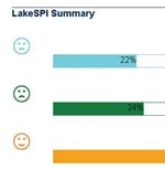
The report card gives a graphic summary of lake conditions with three bar graphs indicating how close a lake is to its best possible condition, or how badly the lake has deteriorated. The first bar shows the lake’s overall ecological condition. The ‘native status’ bar, indicates the diversity and quality of native plant species growing within the lake. Finally, the ‘level of invasion’ bar shows the degree of impact by invasive plants, with a higher score indicating worse condition.
Additional pages explain the rationale behind the method, describe the uses for LakeSPI information, and provide links to the LakeSPI technical manuals.
This web-based resource was developed with NIWA’s Data Management Team and funded in part by the Department of Conservation’s Terrestrial & Freshwater Biodiversity Information System (TFBIS) Programme.
For further information, contact: John Clayton, 0-7-856 1731, [email protected] or Tracey Edwards, [email protected] lakespi.niwa.co.nz
The science behind LakeSPI
The LakeSPI method was developed over the last five years in response to the need for biological indicators for fresh waters. The aim was to design a method that is simple, easy to understand, and which enables lake conditions to be compared over time and, importantly, between very different types of lakes.
The underlying principle of LakeSPI is that any New Zealand lake can be characterised by the composition of native and invasive plants growing in the lake and the depth to which they grow. SCUBA divers follow a procedure to record key vegetation elements at selected sites in a lake. The data are then processed into a score that indicates overall condition; additional scores show how native biodiversity and weed invasion contribute to lake condition.
LakeSPI has undergone substantial testing and modification during its development. The technique is documented in technical manuals and is currently being implemented by the Department of Conservation and four regional councils.
Why spy on lake plants?
Plants are useful indicators of lake ecological health: they’re present year round, they’re easy to measure, and they integrate growing conditions over time. For example, it’s well understood that the depth to which plants will grow reflects the clarity of the lake’s water. Plants also provide a focus on lake margins and littoral zones around a lake where there is greatest public interaction and interest, while water quality sampled from open water in the middle of a lake can indicate different conditions. Lastly, the spread of invasive weed species is a growing concern in this country, with recognised effects on the utility and biodiversity of a waterbody.
