ENSO and Sea Surface TEmperatures
Much warmer than average seas across the whole of the tropical Southwest Pacific A warm ENSO event is possible later this year
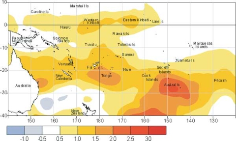
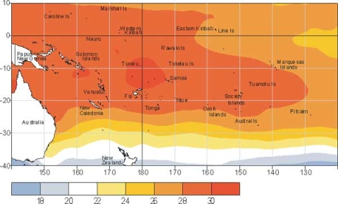
In the tropical Southwest Pacific, a very extensive area of much warmer than usual water at the surface (at least 1.0°C above average) extends from the Coral Sea right across to the region well east of Pitcairn Island, encompassing most islands between 15 and 25°S. The warmest surface waters (30-31°C) surround the Solomon Islands and an area further east between Tuvalu and Samoa. A region of positive SST anomaly (also at least 1°C above average) is well established about the date line (around Kiribati) in the Equatorial Pacific. Negative temperature anomalies continue east of about 150°W, but have weakened since January. Sub-surface sea temperature observations show a very strong positive anomaly (centred at 100-120°W at 50 m depth) in the eastern Pacific, and positive anomalies have broken through to the surface between South America and 100°W over the past few weeks. Most global SST forecast models indicate that the El Niño-Southern Oscillation (ENSO) climate pattern is expected to remain in a near-neutral phase for the next three months. However, an "alert" is in place as there is a possibility that warm ENSO conditions could develop by spring, although it remains too early to make a confident prediction as forecast confidence remains low at this time of year. The Southern Oscillation Index (SOI) has been weakly positive for the past two months, because of above average pressures in Tahiti. The 3-month mean of -0.1 is still neutral, with no sign yet of a negative trend. The trade winds continued to be slightly enhanced in the central Equatorial Pacific, with westerly anomalies in the west (due to a westerly wind burst toward the end of February, although not as strong as the one during December).
Sea surface temperature anomalies (°C) for February 2002

Mean sea surface temperatures (°C) for February 2002

