PDF of this article (2 MB)
Mary de Winton
A database of submerged plant records can be used as a tool to describe lakes and to identify major influences on the composition and distribution of lake vegetation.
Plants growing within lakes integrate changes in environmental conditions over time, and so can tell us a lot more about a water body than “snapshot” measurements of physical or other biological parameters. Moreover, our understanding of how plants relate to lake condition is increasing. In order to improve access to ecological information on submerged plants in New Zealand water bodies, NIWA is developing the NIWA Aquatic Plant Database. This will enable a wealth of information on submerged plants to be accessed and analysed for use by water body managers and researchers alike.
The NIWA Aquatic Plant Database

NIWA currently maintains the database containing over 12,000 plant records from 113 different lakes. These records have been collected over the last 20 years, using a SCUBA survey technique (see “Plumbing the depths”).
To identify surveyed lakes, the database includes unique codes for 988 New Zealand water-bodies. As lakes are often surveyed more than once, a visit number is also assigned for each survey date. Records are then entered by code for each plant species, at each lake site, and associated ecological data are listed. This information can then be retrieved and analysed based on any combination of the identity codes.
Future developments

It is planned to provide web page access to summary information from the database. Soon it will be possible for web users to view maps showing the distribution of New Zealand’s worst water-weeds, or a list of the submerged plants found in a selected lake, their depth range and a measure of abundance. These data can be used for inventories of local flora, State-of-the-Environment reporting, or for assessing weed risk.
NIWA’s database also provides a tool for researchers to discover how plants and lake conditions are inter-related (see “Data for diversity” and “Predicting plant patterns”).
Interpreting data
Teachers: this article can be used for Biology L7 A.O. 7.3. See other curriculum connections at www.niwa.co.nz/pubs/wa/resources
Submerged plants are sensitive indicators for changing water quality, hydrology or aquatic biodiversity. Plants respond to influences over time frames of months to years, so they time-integrate the prevailing lake conditions. Also, they cannot move to escape from unfavourable influences! Therefore, significant changes in the composition and distribution of vegetation mirror change in the state of a lake.
Submerged plants survive short-term reductions in water clarity, but they die if they don’t receive enough light over the long-term. Survey data that show changes in the abundance and depth range of submerged plants can alert water managers to significant water clarity changes in a lake. In response, actions to identify the direction and degree of change (for example, intensified water quality monitoring) can be initiated.
Invasive, introduced water-weeds out-compete native submerged plants, leading to uniform beds of a single species. This has repercussions for lake habitat diversity – for example, see Claustrophobic fish: how do aquatic plants affect fish that feed on invertebrates? With knowledge of the current distribution of a weed species and recent spread, managers can assess the risk of weed introduction to a lake.
We’ll keep you posted!
Mary de Winton is based at NIWA in Hamilton. Learn more about the Aquatic Plants Management programme.
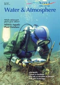
Plumbing the depths

Pioneer naturalists had to be content with dredging up information on what grew in the depths of New Zealand’s lakes. Today, SCUBA equipment makes it relatively easy to gain first-hand information on submerged plants and NIWA researchers have put it to good use.
Our database survey technique involves dives at a number of sites around a water body. At each site divers swim from the shore down into the lake, recording each plant species they encounter, the depth and information about plant abundance and height. The standard nature of the information gathered means that repeated surveys, or different lakes, can be directly compared. Data gathered provide an accurate overall picture of lake vegetation with minimum investment in time.
The data are entered into the NIWA Aquatic Plant Database, from where the information can be accessed and processed in different ways.
Contact: Mary de Winton, NIWA, Hamilton.
Further reading
Clayton, J.S. (1983). Sampling aquatic macrophyte communities. In: Biggs, B.J.F.; Gifford, J.S.; Smith, D.G. (eds), Biological Methods for Water Quality Surveys, pp. 1–22. Miscellaneous Publication No. 54. Water & Soil Division, Ministry of Works and Development, Wellington.
Data for diversity

Database records for amphibious plants found at lake margins have been used to identify the optimum water level regime for plant diversity.
Researchers concluded that maximum diversity of amphibious plants occurred where lake levels generally varied by 1 to 2 m, and where the level changed over cycles of less than two months. Diversity was low where water-level variation was negligible or extreme. They also found that the upper depth limit of the amphibious community was best defined by the level where mean length of dry period was between 10 and 30 days. The community does not generally grow where mean dry days exceeds 30 days.
These findings altogether have important implications for the artificial control of New Zealand’s lakes and rivers. We plan further analysis of database records in conjunction with other physical characteristics of lakes.
Contact: Mary de Winton, NIWA, Hamilton.
Further reading
Riis, T.; Hawes, I. (2002). Relationships between water level fluctuations and vegetation diversity in shallow water of New Zealand lakes. Aquatic Botany, 74(2): 133-148.
Predicting plant patterns


Submerged plants form distinct zones along the depth gradient within lakes. For one group of native plant species, the charophytes, NIWA researchers analysed 2,500 database records to show these patterns in relation to light conditions (% sub-surface light) measured within lakes. While it has been widely understood that low light limits the maximum depth to which charophytes grow, this was the first evidence that light also structures their zonation patterns.
Contact Mary de Winton , NIWA, Hamilton.
Further reading
Schwarz, A.-M.; de Winton, M.D.; Hawes, I. (2002). Species-specific depth zonation in New Zealand charophytes as a function of light availability. Aquatic Botany 72(3–4): 209–217.