Mangrove forests, which are important parts of estuarine ecosystems in a number of ways, are sensitive to changing sea level.
The issue
Mangrove forests are one of the major intertidal – between low tide and high tide – vegetated habitats of tropical to temperate muddy coasts and estuaries. They occupy an estimated 240 000 km2 of intertidal habitat globally.
Mangrove forests perform a range of ecosystem functions, including:
- functioning as long-term sinks for stormwater contaminants (including fine sediments)
- supporting biodiversity and detrital food-webs (mangroves are primary producers)
- providing nurseries for some estuarine and coastal fish species.
They also have the capacity to mitigate coastal erosion and flooding hazards associated with storm waves, extreme tides and tsunami.
Mangroves can only survive in the intertidal zone above mean sea level (MSL). This means that they are sensitive to changing sea level. For the most part, modern mangrove forests have coped with increases in sea level that have occurred over the last century, because the intertidal sediments in which they grow have have been accumulating, keeping pace with increasing sea level. We do not know, however, whether mangrove forests will be able to keep up with the predicted future sea level rises of up to 10 mm per year this century and beyond.
In New Zealand, the rapid filling of estuaries with sediment associated with catchment deforestation (link to Sedimentation in NZ estuaries article) has created new habitat for our only mangrove species, Avicennia marina. Aerial photographs show that the distribution of mangroves in upper North Island estuaries has substantially increased since the 1940s, spreading at an average rate of 4% per year (range 0–20% per year). This is twice the rate observed in southeast Australian estuaries (2.1 % per year, range 0.7–9.1 % per year), where Avicennia marina-dominated forest also occurs.
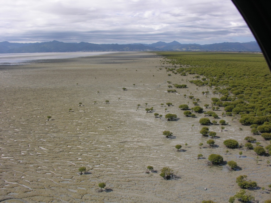
The rapid expansion of mangrove forests in NZ estuaries over the last several decades has resulted in large-scale and permanent environmental changes (Fig. 1). Effects include increased displacement/loss of other estuarine habitats such as salt marshes, sand flats and shellfish beds; impacts on navigation and recreational use; and changes in aesthetics and natural character of estuaries. However, some large areas of newly formed tidal flat above mean sea level have still not been colonised, even decades later. In large, wave-dominated estuaries such as the Firth of Thames, this time lag between tidal-flat formation and mangrove colonisation has been linked to seedlings beings killed by the erosion of the tidal flat by waves (Morrisey et al. 2010).
Mangroves are viewed by some as being opportunistic colonisers of intertidal flats once the flats have become "ecologically suitable". This implies that mangroves do not actually influence how estuaries evolve; rather, they take advantage of it.
An alternative view is that mangrove forests enhance sedimentation, meaning that mud accumulates faster in the presence of mangroves than it would otherwise on unvegetated intertidal flats.
It has been difficult to settle the debate, as many observations of sedimentation in mangroves forests have been short term, on the order of days to months, and rarely over years. This means we have not been able to observe the full range of processes, feedbacks and events that drive the development of mangrove forests, which occurs over decades and longer.
Conversely, reconstructions of mangrove forest development that have been based on longer-term records (e.g., sediment cores) have typically been qualitative and/or lacked enough detail on shorter timescales to allow us to understand the interplay of sediment–plant processes. Even quantitative measurements of sedimentation in modern mangrove forests are rare.
NIWA research since 2007 is shedding light on the role of mangrove forests on sedimentation and the long-term development of New Zealand estuaries.
The approach
Whether or not mangrove forests are accelerating sedimentation and thereby influencing the long-term development of New Zealand estuaries is being addressed based on observations made over a range of timescales relevant to mangrove-forest ecosystems.
Methods include:
- measuring the delivery of sediment by wave resuspension of tidal-flat sediments, river discharge and storm tides to mangrove forests (timescale hours to days)
- measuring sedimentation and bed-sediment surface elevation changes (timescale months to years)
- reconstructing mangrove-forest development (timescale years to decades) based on radioisotope dating and stable-isotope analysis of high-resolution sediment cores, and using detailed records of mangrove forest development provided by aerial photography.
Much of this work is being conducted in the southern Firth of Thames, where mangroves have colonised 11 km2 since the early 1950s. This site has yielded a number of insights into processes controlling mangrove forest development, largely because the system is evolving very rapidly and measurable environmental changes are occurring over timescales of weeks to months. For example, the sediment accumulation rate has averaged several centimetres per year, as opposed to the several millimetres per year observed in most New Zealand estuaries. Sediment cores collected from the Firth mangrove forest thus contain highly detailed records of environmental change over time.
On a day-to-day basis, the interplay of tides, weather, and river flows controls the supply of sediments to mangrove forests. Waves resuspend intertidal-flat sediments and rivers discharge eroded soils into estuaries. Tides as well as weather conditions are also important because they control the frequency and duration of inundation (called the hydroperiod) and consequently sediment delivery to mangrove forests.
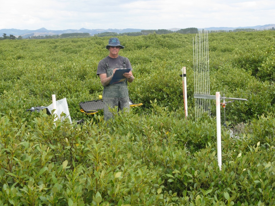
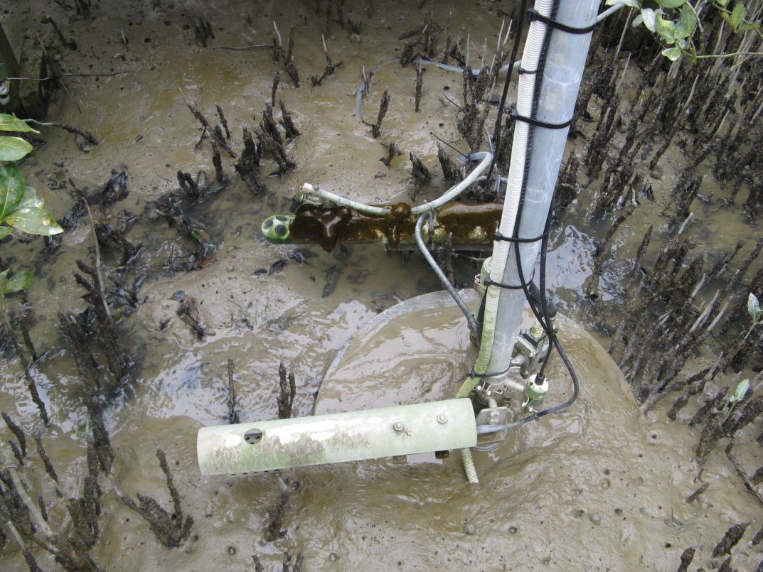
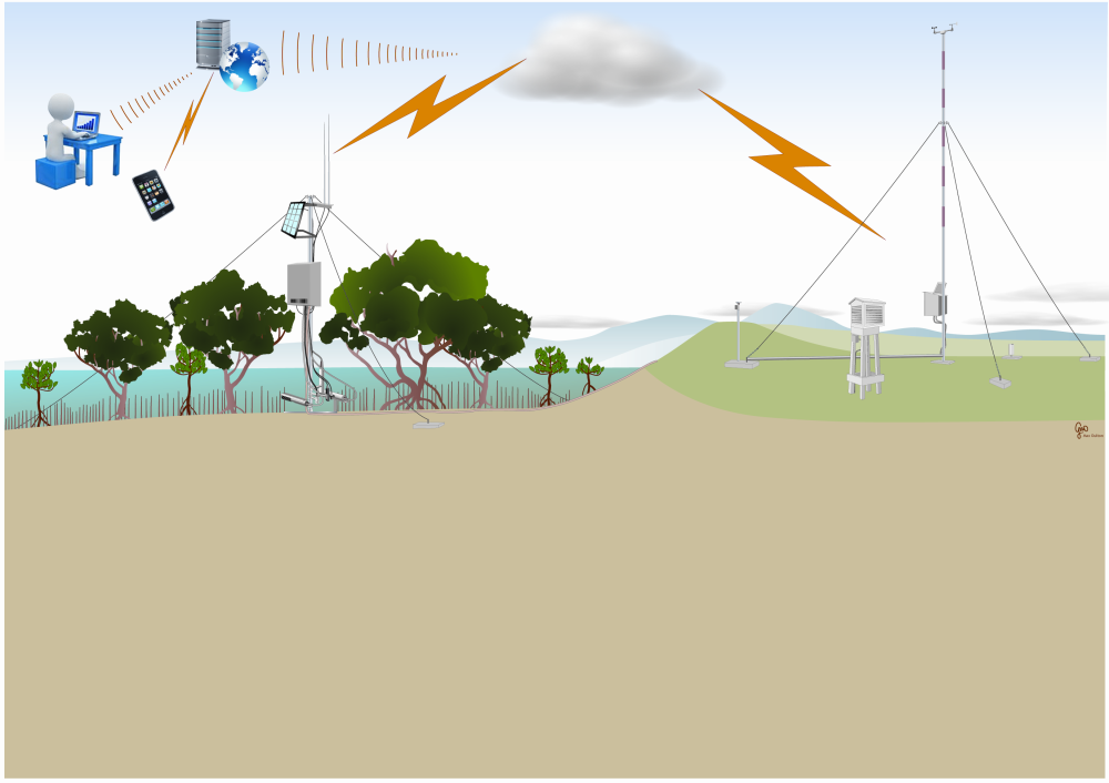
The relative importance of the various mechanisms of sediment delivery are being determined using a semi-autonomous telemetered* instrument system that incorporates a weather station and oceanographic sensors that measure currents, water levels, turbidity and salinity (Fig. 2). These observations are being used to inform the interpretation of sediment accretion and changes in level of the bed sediment within the mangrove forest.
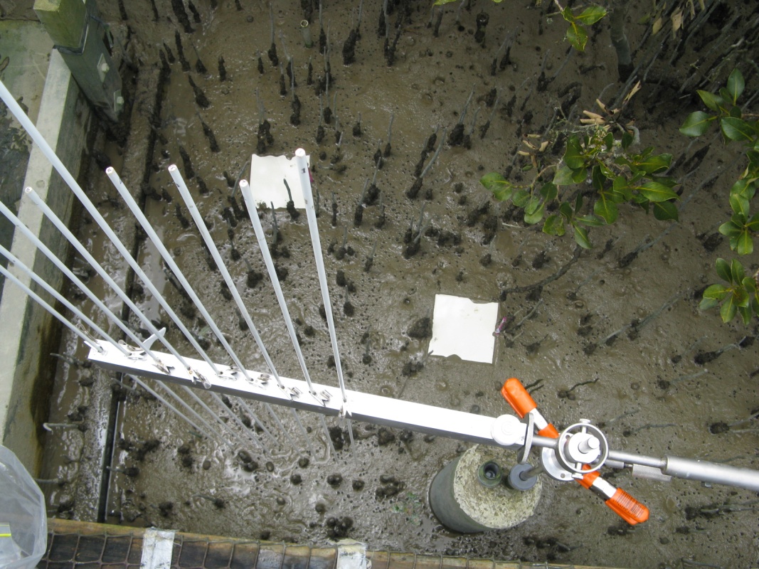
Changes in the level of bed sediments in mangrove forests reflect the balance between the rates at which sediment is supplied, the hydroperiod, and processes such as subsidence (shallow and deep) and the accumulation of biomass. Surface elevation tables (SET), which measure changes in the sediment level to millimetre accuracy, have been deployed at nine sites in the forest since 2007 to tease out the relative contributions of these processes (Fig. 3). Along with other measurements, hydroperiod (the period of time during which the bed is covered by water) and the effects of subsidence due to compaction of sediment deposits as they are buried by on-going sedimentation have been measured.
The final strand of this research is a detailed reconstruction of mangrove forest development since the 1950s, based on analysis of dated sediment cores and a detailed aerial photographic record stretching from 1940 to 2007. The methods used for sediment dating are described in the related article Sedimentation in New Zealand estuaries.
* Telemetry is the use of a wireless communication system to relay data from a field station to a remote computer at another location
The result
NIWA's mangrove research is now providing information on the role of mangrove forests in sedimentation and the long-term geomorphic development of New Zealand estuaries.
A key finding of this work to date is that mangrove forests do not increase sedimentation rates in estuaries over a timescale of years to decades. It would appear, therefore, that mangroves are opportunistic colonisers of intertidal flats, and do not strongly influence the geomorphic evolution of estuaries.
Our observations in the southern Firth also show that deep subsidence of the tidal flats is a major factor controlling mangrove forest development. Independent data from sediment cores and continuous GPS surveys of the SET benchmarks over the last five years show the tidal flats and mangrove forest are subsiding at a near constant rate of 7 mm per year. This rate is five times higher than the present rate of sea-level rise measured at the Port of Auckland. The net result is a relative (i.e., local) rate of sea level rise (SLR) of close to 10 mm/yr.
The implication of this result is that mangrove forests will only be able to keep pace with future predicted rates of SLR in estuaries where enough sediment is accumulating to keep up. In the Firth of Thames, sediments have primarily been supplied by the redistribution by waves of intertidal flat deposits that have accumulated over the last ~200 years due to deforestation and river-engineering works. Current river inputs are only of secondary importance.
This work has been funded by Waikato Regional Council and the Foundation for Research, Science and Technology (Effects-Based Protection and Management of Aquatic Ecosystems, C01X0307).
Reference
Morrisey, D.J., Swales, A., Dittmann, S., Morrison, M.A., Lovelock, C.E., Beard, C. M. (2010). Ecology and Management of Temperate Mangroves. Oceanography and Marine Biology: an Annual Review 48: 43–160.