A strong marine heatwave is contributing to New Zealand’s unusually hot weather, says NIWA.
Meteorologist Ben Noll says that sea surface temperatures around Auckland are borderline tropical.
"A rapidly intensifying marine heatwave has caused sea surface temperatures to reach a near-record 23-24˚C in some coastal areas in late January. It’s striking."
Ben Noll, NIWA Meteorologist

“Since the first big marine heatwave back in 2017-18, they have become commonplace for New Zealand, happening in more summers than not. They seem to generate less and less fanfare, but this one is really standing out,” said Mr Noll.
Marine heatwaves are periods of unusually warm ocean temperatures. They have far-reaching impacts, affecting everything from ecosystems to economics.
They also influence weather patterns, priming the environment for tropical cyclones, like Tropical Cyclone Kirrily that has formed off the coast of Australia, while causing hotter and more humid conditions on land.
This partly explains why the North Island is experiencing above normal humidity levels, which are keeping nighttime temperatures elevated.
"The fact that this marine heatwave is coinciding with the typical annual peak means it’s stacking a 2-3˚C anomaly on top of the ocean warming we normally see at this time of the year. Swimmers and surfers will have likely noticed the unusually warm waters," said Mr Noll.
Ben Noll, NIWA Meteorologist
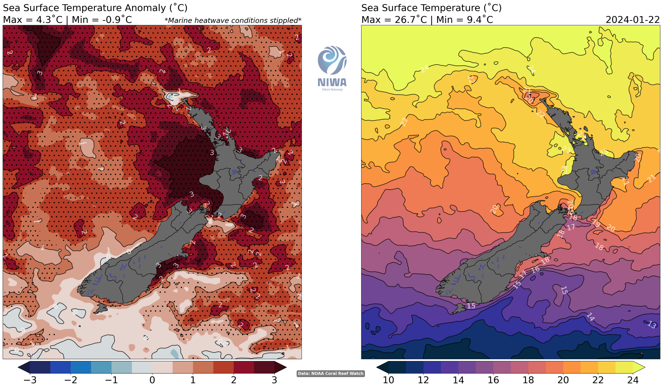
NIWA physical oceanographer Erik Behrens says the large warming around the North Island is unusual and does not align with the pattern which we would typically expect during El Nino.
“The temperatures around the South Island are more aligned with our expectations, where stronger south westerly winds as part of El Nino cause coastal upwell of cold water, reducing the likelihood for marine heatwaves,” said Dr Behrens.
2024 has already seen record-breaking temperatures, with places such as Wellington Airport recording its highest January temperature since records began in 1962, and over 50 locations tracking toward a near-record or record warm month. The marine heatwave intensity may ebb and flow over the next two weeks owing to more variable temperatures, wind flows, and cloud, but an intensification may occur from the second week of February.