At a rough count, 700 million litres of rain runs off the nation’s roads every year. That’s enough water to fill almost 300 Olympic-sized pools.
But it’s not necessarily water you’d want to fill a pool with. In places, it is contaminated by toxicants such as fuels, additives, oil, and brake and tyre residues. The areas that receive this road runoff vary widely. Even where stormwater pipes and ditches are built alongside roads, road runoff sooner or later ends up in streams, rivers, lakes, wetlands, estuaries, harbours and coastline.

Jonathan Moores, an Urban Aquatic Scientist with NIWA, explains that the key threat is where road runoff delivers high levels of contaminants to sensitive water bodies.
“Runoff can be a threat to water bodies because of short-term elevated levels of toxicants in water and their long-term accumulation in sediment.”
“So we need to know where road runoff presents the greatest risks of these short and long-term effects. We can then target those places with improved stormwater management and treatment.”
Moores says investigations of the effects of runoff had previously tried to understand the level and type of contaminants produced from roads.
“Until now we’ve not really had a tool for assessing its effects on receiving environments. We’ve needed a way of understanding both the local and more far-reaching effects of road runoff.”
Regional councils are beginning to move toward risk-based stormwater consenting regimes, in support of the Government’s National Policy Statement for Freshwater Management 2014. Without a way of knowing what impacts runoff has after it is channelled off the road, road-builders may be required by regulatory authorities to over-engineer or even under-engineer solutions. That’s why the New Zealand Transport Agency (NZTA) wants to know more about the conditions in which stormwater runoff from roads could harm the environment. NZTA is responsible for all state highways, as well as providing guidance for road operations by local councils.
Armed with information about the estimated contaminant load of runoff, and local topography and waterways, road designers can decide the best sort of drainage to install. To estimate the effect of runoff from particular stretches of road, the Agency had previously developed a model called the Vehicle Kilometres Travelled (VKT) screening tool. The tool focused on the ‘downstream’ effect—how much contaminant would make it to estuaries and coasts—and used VKT as a surrogate measure for contamination.
NZTA contracted NIWA and MWH Global, an engineering consultancy, to make the model also applicable to rivers and streams and to use estimates of contaminant levels, rather than VKT, as the basis of the risk assessment.
Calculating contaminant loads
Carol Bannock, environmental specialist at NZTA, said the project involved a number of significant tasks so that effects on both freshwater and coastal waterbodies could be assessed.
“We need a robust, consistent method for establishing the relative risk of adverse effects from road runoff that can be applied anywhere in New Zealand using existing datasets.”
That meant crafting the tool to also calculate contaminant loads from sources other than roads in built-up urban environments.
“It required factoring in the effects of pathway attenuation, traffic congestion and non-road pollution sources.”
Moores explains that a significant component of urban runoff is copper and zinc from roofs and building materials, as well as road-related sources such as car brake linings and tyre wear.
“Copper and zinc are important, both in their own right as ecotoxicants, but also as indicators of wider contamination of water bodies from other stormwater-related contaminants.”
Copper is about 5 to 10 times more toxic to aquatic life than zinc, but road runoff generally contains something like five times as much as zinc as copper. The zinc to copper ratio can be even higher than this in stormwater from other urban land uses. Previous studies have found sediments in urban Auckland estuaries containing 12 to 35 parts per million of copper and 60 to 220 parts per million of zinc. Marine life begins to be affected at concentrations of 34 and 150 parts per million, for copper and zinc respectively.
Moores says the tool aims to take into account the cumulative effect of contaminants rather than zinc or copper in isolation.
“A key assumption of the method is that elevated concentrations of copper and zinc together can be more harmful than one in the absence of the other.”
While NZTA’s intention was to improve the screening method for road networks, a secondary objective was to describe ways in which the method could be extended to provide for an absolute risk assessment in relation to established effects thresholds.
The resulting tool is valuable for what Moores describes as its “relative assessment scale”.
“We can pinpoint those areas most sensitive to the contaminated water running off nearby roads. This is where the risk is greatest, based on the characteristics of both the runoff from the road and the characteristics of the receiving environment.
“High risk discharges are red-flagged, taking into account the sensitivity of the environment and the levels of contaminants in the discharge from the road.”
The model does that by estimating in-stream copper and zinc concentrations relative to guideline safety concentrations. It matches those against the sensitivity of the receiving environment, which is based on existing modelled values of a macroinvertebrate community index.
The model contains a number of linked modules and runs in readily available software platforms (Excel and ArcGIS). Input data includes river flow estimates, assessments of estuary deposition rates, land use information, road traffic data and road drainage design details. The tool can produce hotspot maps, showing the relative risk across sub-catchments. Users of the tool can then drill in to look at the road network within a given sub-catchment to look for the roads which generate the highest contaminant loads.Where the tool signals that road runoff presents a risk to receiving water bodies, Bannock says road drainage can be designed, or retrofitted, with stormwater treatment systems.
“Stormwater treatment devices include engineered ponds and wetlands that allow the contaminants to settle out and systems such as raingardens, swales and media filters that remove contaminants by filtration,” she says.
Bannock says the study has been very successful, and is likely to play an increasing part in road management.
“It will be used to inform road operation and maintenance contracts, efficient application of stormwater management and treatment on road improvement projects, and development of regional plans and resource consent conditions.
“Other applications include a ‘drill down’ facility to screen the road network for contaminated load ‘hot spots’ and apportioning contaminant loads between local roads and state highways. Even better, it can analyse catchments to identify which roads and urban areas are most troublesome.”
Porirua testbed
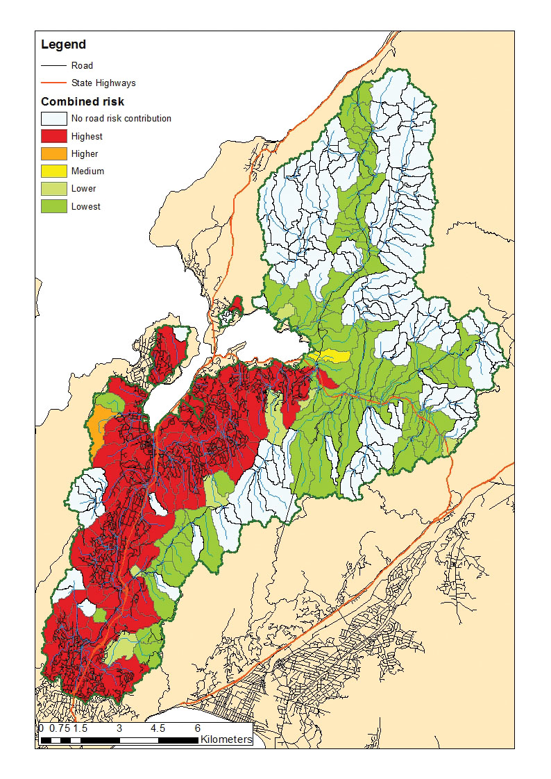
The new model was tested around Porirua Harbour, on the west coast of Wellington. According to Bannock, the diverse road and land mix of the area made it a good testing ground, being similar to many other New Zealand catchments.
“The Te Awarua-o-Porirua Harbour and its catchment comprises a 178 square kilometres mix of local roads and state highways that discharge to streams of varying dilution potential.”
Critically, it also includes the coastal waterbodies of Pauatahanui Inlet and Onepoto Arm.
“The sub-catchments of these two waterbodies contain markedly different urban/rural land use (with Onepoto more urbanised), allowing for model evaluation under widely different catchment conditions.”
The Porirua test revealed that the model could be used to analyse whole catchments for road contaminant contributions.
The NIWA and MWH team worked to extract, collate and quality check input data from a range of sources. These included GIS and Asset Management files on the water bodies, roads and land use of the case study area.
The model projected contaminant levels across the region’s waterways, which were then compared with the results of council monitoring. The research team found that the actual contaminant levels corresponded closely to the levels predicted by the model.
The tool produced maps showing the risk assessment of zinc and copper in streams within reach of runoff from the road and urban contaminant sources [see graphic below]. It also produced risk assessment maps for discharge points to the harbour.
The model showed that 36 stream reaches were ‘highest risk’ based on consideration of road runoff alone; 103 stream reaches were ‘highest risk’ based on consideration of urban (non-road) runoff alone; and 107 stream reaches were ‘highest risk’ based on consideration of road and urban runoff combined.
Flow-on effects
NZTA’s next step is to make the model user-friendly and then encourage its use by local authorities, road builders and others interested in waterway health.
“We’ll test the model on a number of actual road improvement projects, and tweak it following feedback and lessons learned from end users,” Bannock says.
“Once we’ve worked through these steps, the aim is to promote its widespread use as a screening tool in road projects.”
Working on water
The New Zealand Transport Agency has produced a more accurate tool to help design the best sort of stormwater treatment based on measures of how runoff could harm the environment.
The new tool adapts the previous estuaries and coast risk model so it is applicable to rivers and streams. This new estimate of contaminant levels is now the basis of the road runoff risk assessment. Where the tool signals that road runoff presents a risk to receiving water bodies, road drainage can be designed, or retrofitted, with treatment systems such as engineered ponds and wetlands and systems such as swales and media filters.
The new tool will also inform road operation and maintenance contracts, road improvement projects, and regional plans and resource consent conditions.