A weekly update describing soil moisture patterns across the country to show where dry to extremely dry conditions are occurring or imminent. Regions experiencing significant soil moisture deficits are deemed “hotspots”. Persistent hotspot regions have the potential to develop into drought.
Facts: soil moisture
In the North Island, light rainfall amounts were observed in most areas during the past week. Some parts of the North Island received moderate falls of 15-40 mm, including around Wellington Central, the Kāpiti Coast, parts of Manawatū-Whanganui, and pockets of Hawke’s Bay. Most other areas of the North Island received generally light falls (less than 10 mm), with little-to-no rainfall in Northland and Auckland. This resulted in soil moisture decreases across most of the North Island, with significant decreases across parts of Northland, Auckland, Waikato, Bay of Plenty, and the Manawatū-Whanganui. The driest soils across the North Island, when compared to normal for this time of year, are found in eastern Wairarapa, while the wettest soils for this time of year around found in parts of coastal Gisborne and the Far North.
During the past week, the hotspot over the Wairarapa expanded slightly. The New Zealand Drought Index (NZDI) map below shows that dry conditions continued to be located in the Wairarapa, with slim area of very dry conditions now emerging along the eastern coastal strip.
In the South Island, a burst of heavy rainfall across the west resulted in widespread amounts of 75-170 mm, including places like Westport, where 97 mm fell on 27 Nov, and Greymouth, where 165 mm fell on 27 Nov. Persistent north-easterly winds across the east resulted in 20-50 mm for some parts of the Canterbury High Country and coasts. Lake Tekapo observed 47 mm in the last week, while Timaru observed 23 mm and Ashburton 35 mm. However, parts of upper Marlborough, Otago and Southland received less than 15 mm in the last week. This resulted in modest soil moisture increases for most of the South Island, with some significant increase about Canterbury and Marlborough, although small decreases in soil moisture were observed around coastal Fiordland. The driest soils across the South Island, when compared to normal for this time of year, are found in Nelson and parts of Fiordland, while the wettest soils for this time of year are found in inland Southland and about the Mackenzie region.
Hotspots have eased for the Canterbury and Marlborough due to the rainfall over the last week. The New Zealand Drought Index (NZDI) map below shows that dry conditions are still located in coastal Ashburton District, while dry conditions have emerged for the eastern Banks Peninsula as of 30 November.
Outlook and soil moisture
In the North Island, high humidity along with an unstable atmosphere will bring scattered showers and areas of light rain to central and coastal areas from Friday (3 December) to Sunday. From Monday (6 December), a front will cause widespread rain and showers, with the potential for moderate-to-heavy rainfall for central and western areas. Some isolated regions adjacent to the ranges may receive as much as 60 mm, while those to the east of the main divide may receive less than 20 mm with this system. By Wednesday, most of the rain should clear, although some showers could remain for northern regions. Broadly speaking, near-to-above normal rainfall is expected for western regions, while near-to-below normal rainfall is expected in the east in the next week.
Due to the expected rainfall in the next week, soil moisture levels look to remain unchanged or perhaps decrease, particularly east of the main divide. Existing hotspots in the Wairarapa may expand further, while areas about the Central Plateau may see an emergence of a hotspot if showers fail to produce adequate rainfall.
In the South Island, areas of persistent rain and showers over western and northern areas will continue on Friday (3 December), with rainfall then intensifying this weekend as a front crosses. This rain could be particularly heavy for western regions, three day totals (Friday - Sunday) possibly exceeding 200-300 mm for areas about Greymouth to Haast. The proceeding southerly change then looks to trigger areas of rain and showers parts of Southland, Otago, and the Canterbury, with totals up to 25 mm possible, heaviest about the south and higher grounds, before largely clearing to isolated showers on Monday (6 December). High pressure then looks to bring a period of dry weather from about Tuesday across the South Island.
Due to the expected rainfall, soil moisture levels look to increase slightly for western and perhaps some southern areas. Areas about the Canterbury and Marlborough, which have enjoyed a recent increase in soil moisture levels, may see a mixed result in soil moisture; southern areas may increase or remain the same, while northern areas experience steady, or perhaps decreasing, soil moisture levels.
Background
Hotspot Watch: a weekly advisory service for New Zealand media. It provides soil moisture and precipitation measurements around the country to help assess whether extremely dry conditions are imminent.
Soil moisture deficit: the amount of water needed to bring the soil moisture content back to field capacity, which is the maximum amount of water the soil can hold.
Soil moisture anomaly: the difference between the historical normal soil moisture deficit (or surplus) for a given time of year and actual soil moisture deficits.
Definitions: “Extremely” and “severely” dry soils are based on a combination of the current soil moisture status and the difference from normal soil moisture (see soil moisture maps).
Hotspot: A hotspot is declared if soils are "severely drier than normal" which occurs when Soil Moisture Deficit (SMD) is less than -110 mm AND the Soil Moisture Anomaly is less than -20 mm.

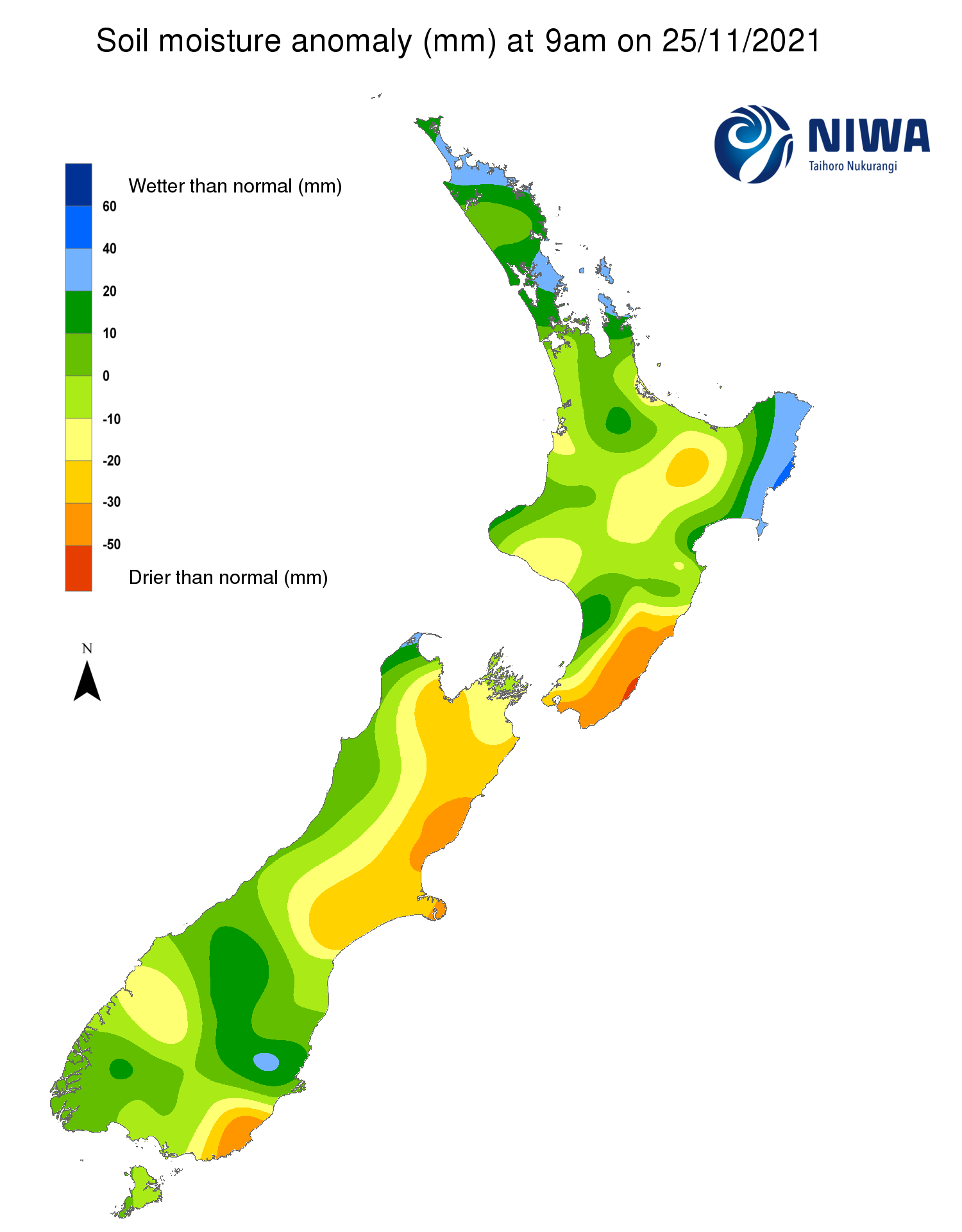
Pictured above: Soil Moisture Anomaly Maps, relative to this time of year. The maps show soil moisture anomaly for the past two weeks.
As of 30 November, the New Zealand Drought Index (NZDI) map below shows that dry-to-very dry conditions are now located in coastal Wairarapa and dry conditions are in Ashburton District and eastern Banks Peninsula. Please note: some hotspots in the text above may not correspond with the NZDI map. This difference exists because the NZDI uses additional dryness indices, including one which integrates the rainfall deficit over the past 60 days. Changes are therefore slower to appear in the NZDI compared to soil moisture anomaly maps that are instantaneously updated.