A weekly update describing soil moisture patterns across the country to show where dry to extremely dry conditions are occurring or imminent. Regions experiencing significant soil moisture deficits are deemed “hotspots”. Persistent hotspot regions have the potential to develop into drought.
Facts: Soil Moisture
In the North Island, Cyclone Fili delivered widespread 50-120 mm of rainfall in already very wet areas of eastern Gisborne and northern Hawke’s Bay. Wairoa collected 83 mm of rainfall over the week, nearly two-thirds of their April monthly normal. Although 73 mm of this weekly total fell within a 24 hour period, it was 4th time so far this year Wairoa has recorded daily totals in excess of 70 mm. Eastern Northland, Auckland, the Coromandel, parts of the Bay of Plenty and the rest of Hawke’s Bay also collected 10-40 mm from the same system. West of the ranges and plateau, it was drier, with less than 5 mm recorded for much of the Manawatū, southern and western Waikato and Taranaki. This resulted in soil moisture increases across much of the eastern and northern North Island, with soil moisture decreases for western Northland, Waikato, Taranaki, Manawatū-Whanganui and Wellington west of the Wairarapa. The driest soils across the North Island, when compared to normal for this time of year, are found in western Northland north of Kaipara Harbour, while the wettest soils for this time of the year are found along the east coast.
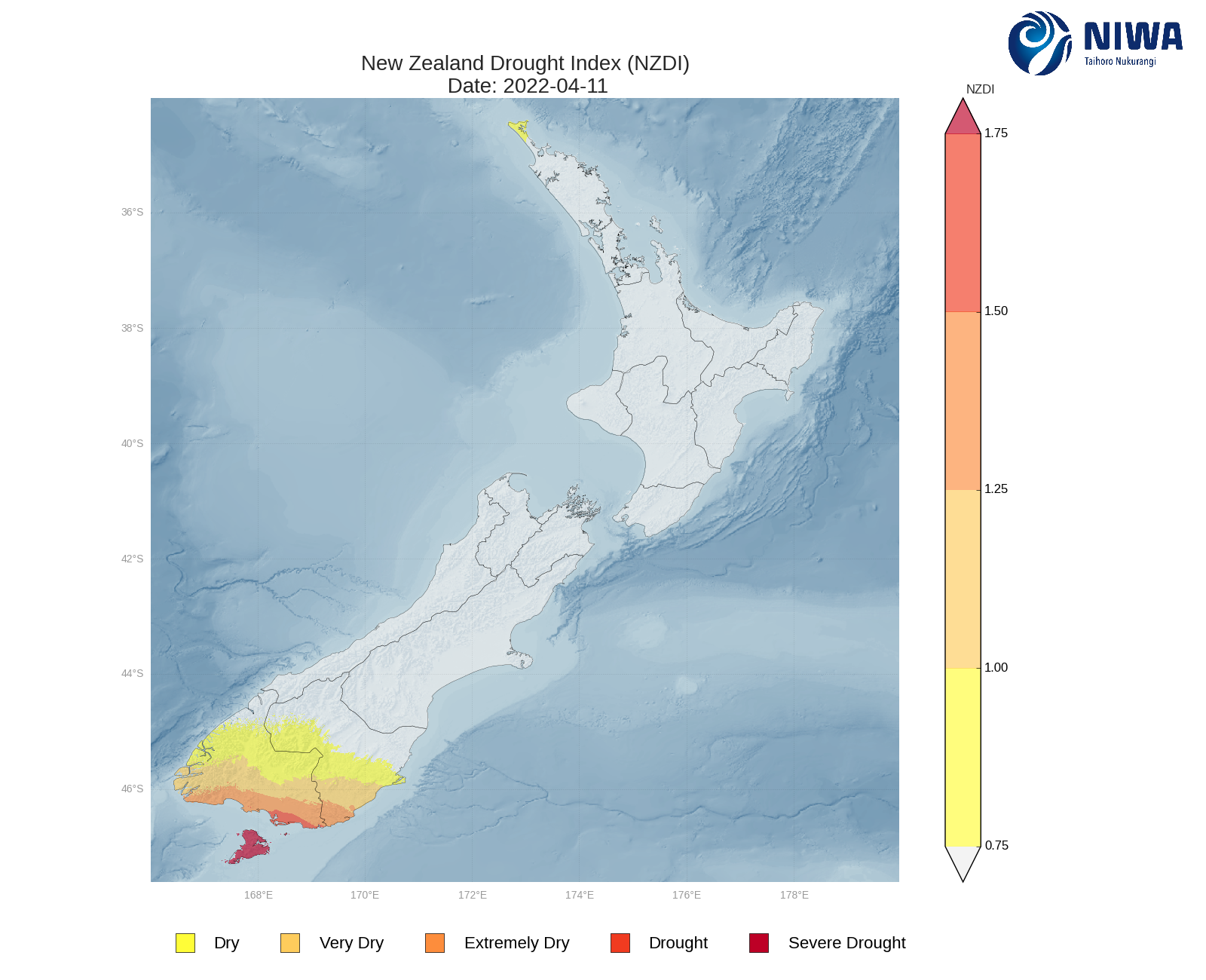
A hotspot has expanded in northern Northland north of Kaipara Harbour, and a small hotspot remains in the Firth of Thames. As of 11 April, the New Zealand Drought Index (NZDI) map below shows a small area of dry conditions are located on the Aupouri Peninsula.
In the South Island, West Coast and Fiordland recorded widespread 50-100 mm of rainfall, and the dry Southland region also received good rainfall totals of 30-50 mm. Across the Southern Alps in Otago and Canterbury, 10-30 mm of rainfall was observed, while northern Canterbury and Marlborough received 10 mm or less, and Nelson was dry. Milford sound’s 118mm of rain on Sunday was the wettest day in over a month. Tiwai Point, close to where a large fire is still burning, received an additional 23 mm on top of the 31 mm of rain last week. This resulted in soil moisture increases for Southland, and slight reductions in soil moisture for Nelson, while the rest of the South Island remained largely the same. The driest soils across the South Island, when compared to normal for this time of year, still remain in Southland and Rakiura/Stewart Island, while the wettest soils are found in northern coastal Canterbury, about Kaikoura.
Hotspots have remain over much of Otago, although have eased back for much of Southland excluding some northern areas and Rakiura/Stewart Island. Small hotspots are emerging in Nelson and parts of coastal Canterbury about Timaru and west of Lake Ellesmere. As of 11 April, the New Zealand Drought Index (NZDI) indicated that meteorological drought or severe meteorological drought remains in Southland and Stewart Island. For the rest of Southland and southern Otago excluding the area around Milford Sound, the NZDI indicates that conditions are dry-to-extremely dry.
Outlook and Soil Moisture
In the North Island, a low pressure system looks to bring rain, showers and isolated thunderstorms to the North this weekend (Saturday 15th and Sunday 16th). Isolated, heavy rainfall totals are possible, particularly in thunderstorms, where as much as 50-100 mm could fall. However most areas will see 5-20 mm. Scattered showers and thunderstorms may linger across the central and northern North Island during the week before a front brings scattered showers to western and southern areas later next week. All up, central and western areas may see up to 30 mm, while areas about the east look to see a much drier week compared to the last, although some isolated heavier rainfall totals are still possible about far north East Cape.
In the South Island, a and of moderate-to-heavy rainfall looks to move over Fiordland, Southland and the West Coast on Saturday 15th , delivering widespread 20-80 mm about western areas, and 5-15 mm for other parts of Southland and southern Otago. It then looks to be mostly dry until another front later next week brings more rain and scattered thunderstorms to western areas. A southerly change may then deliver moderate rainfall to some regions east of the main divide. 50-150 mm is predicted for areas in the west south of about Hokitika, with 25 mm or less for eastern areas.
Soil moisture levels may remain the same for western areas, remain the same or decrease for eastern and northern areas, and decrease slightly for northern areas. Hotspots in Southland and Otago are unlikely to ease, while the hotspots in Nelson and coastal Canterbury may expand.
Background:
Hotspot Watch: a weekly advisory service for New Zealand media. It provides soil moisture and precipitation measurements around the country to help assess whether extremely dry conditions are imminent.
Soil moisture deficit: the amount of water needed to bring the soil moisture content back to field capacity, which is the maximum amount of water the soil can hold.
Soil moisture anomaly: the difference between the historical normal soil moisture deficit (or surplus) for a given time of year and actual soil moisture deficits.
Definitions: “Extremely” and “severely” dry soils are based on a combination of the current soil moisture status and the difference from normal soil moisture (see soil moisture maps at https://www.niwa.co.nz/climate/nz-drought-monitor/droughtindicatormaps)
Hotspot: A hotspot is declared if soils are "severely drier than normal" which occurs when Soil Moisture Deficit (SMD) is less than -110 mm AND the Soil Moisture Anomaly is less than -20 mm.
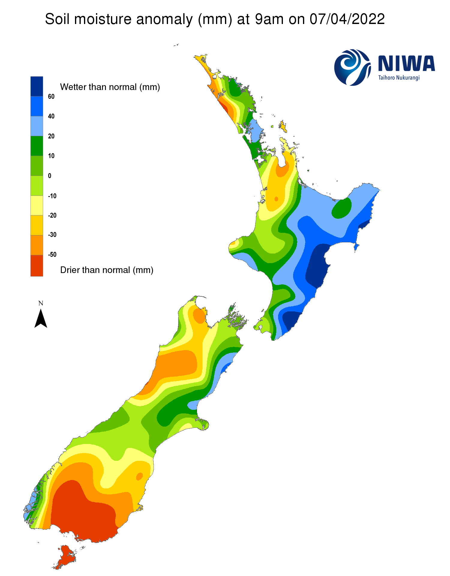
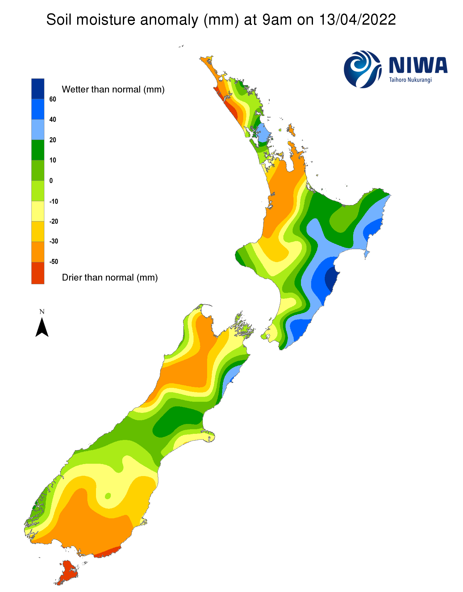
Pictured above: Soil Moisture Anomaly Maps, relative to the time of year. The maps show soil moisture anomaly for the past two weeks.
New Zealand Drought Index (NZDI)
As of 6 April, the New Zealand Drought Index (NZDI) below indicates meteorological drought or severe meteorological drought in lower Southland and Stewart Island, with dry-to-extremely dry conditions in southern Southland and southern Otago. Meanwhile, isolated spots of dry conditions are present in northern Northland. Please note: some hotspots in the text above may not correspond with the NZDI map. This difference exists because the NZDI uses additional dryness indices, including one which integrates the rainfall deficit over the past 60 days. Changes are therefore slower to appear in the NZDI compared to soil moisture anomaly maps that are instantaneously updated.