Among the multitude of New Zealand climate statistics there is one record that continues to be broken month after month.
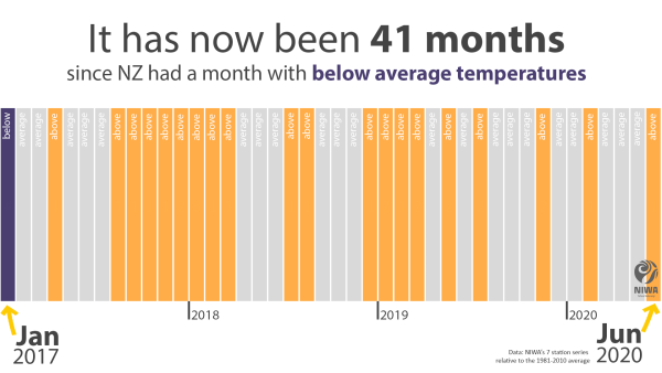
Since January 2017 there has not been one month that recorded a below average nationwide temperature, according to NIWA’s seven station temperature series. That’s a total of 41 consecutive months in which the temperature has not slipped more than 0.5ᵒC below the long-term (1981-2010) average. And of those 41 months, 20 have had above average temperatures and 21 have been near average.
New Zealand's warming climate
NIWA meteorologist Ben Noll says that is clear evidence of New Zealand’s warming climate.
“Our baseline for warmth is changing. Having 41 consecutive months without a single chilly interlude, considering the nation as a whole, is striking.”
The first six months of 2020 have produced a number of other significant climate statistics:
- Auckland has had its second driest January to June on record with just 310 mm of rain recorded
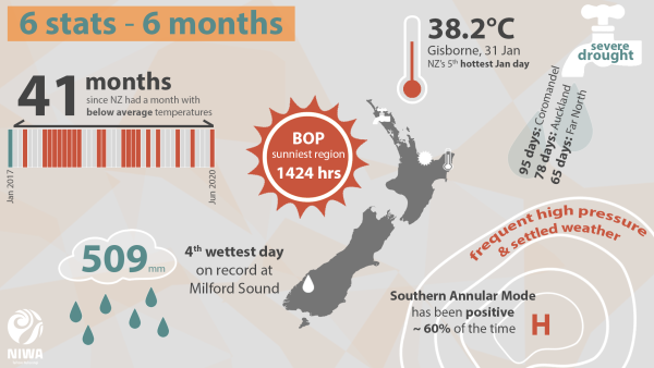
- The Coromandel Peninsula had 95 days of drought or severe drought – Auckland had 78, according to the New Zealand Drought Index
- Gisborne recorded the top temperature in New Zealand of 38.2ᵒC on January 31. This was also the city’s hottest temperature on record
- 28 locations observed their highest maximum or minimum air temperature from January-June
- New Zealand’s nationwide temperature anomaly was 0.47ᵒC above average during January-June, according to NIWA’s seven station series
- It was New Zealand’s 5th warmest June on record
- The sunniest region so far this year is the Bay of Plenty with 1424 hours
- The highest one-day rainfall was 509mm at Milford Sound on February 3
- From February 1-4 Milford Sound received 1104 mm of rain or 16% of its annual normal
High pressure has frequented New Zealand’s north throughout the year, bringing dry weather patterns and keeping rain bands suppressed to the south.
The Southern Annular Mode has been positive about 60% of the time — a positive Southern Annular Mode generally means more tranquil weather around NZ. Trends in the positive direction, meaning more frequent ridges of sub-tropical high pressure particularly during summer, are consistent with climate change expectations.


