PDF of this article (262 KB)


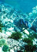
Reyn Naylor, Russell Cole, and Rob Stewart have investigated some new territory to map seaweeds on our rocky southern shores.
Seaweed distribution
Because of their wide variety of forms and physiologies, seaweeds survive over large environmental ranges, from tranquil inlets to the severe conditions frequently found on our shallow wave-exposed coasts. The distribution of seaweeds on New Zealand reefs has been best described for our northern shores; until recently the less accessible rocky shores of Stewart Island and Dusky Sound had received little attention.
Our FRST-funded work aims to characterise seaweeds around southern New Zealand and improve our understanding of the principal factors affecting their ecology. Here, we briefly describe some of the general distribution patterns we’ve observed in these areas. The seaweeds in our study are mainly in the group known as large brown algae and are commonly referred to as kelp. Depth (which affects light penetration), wave action, sedimentation, nutrient levels, temperature, and grazing are all considered to influence algal distribution.
Water characteristics and depth
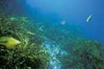
In Fiordland’s Dusky Sound the waters are frequently characterised by a shallow, low-salinity surface layer. At the sites we examined there, the most common large brown algae were Carpophyllum flexuosum, followed Ecklonia radiata, Cystophora, and Sargassum. In the relatively clear waters of the east coast of Stewart Island, the most abundant large brown algae were Ecklonia radiata, followed by Marginariella boryana, Carpophyllum flexuosum, and Landsburgia.
In Dusky Sound, we found depth-related patterns in the abundance of Carpophyllum flexuosum and Ecklonia radiata. Most Carpophyllum plants were 2 to 6 m deep, after which there was a very obvious decline. This contrasts with the clearer waters of the offshore islands northeast of New Zealand, where dense forests of Carpophyllum grow at 10 m or deeper.
Ecklonia radiata showed a preference for slightly deeper habitat, but in one area of Dusky Sound it flourished at two different depths. This bimodal distribution appears to be due to the greater numbers of kina between about 3 and 7 m depth: the ability of grazer populations to reduce algal densities is well documented, and the relationship between kina and Ecklonia at this site in Dusky Sound is a good example. We also found a strong relationship between distribution and depth for most of the large brown algae sampled at Stewart Island.
Waves
Wave action affects the distribution of several species at both Stewart Island and Dusky Sound. Although it is difficult to measure, NIWA scientists were able to estimate wave action using a sophisticated wave model that integrates the processes of wave energy due to wind and currents, wave–wave interactions, and energy losses due to whitecaps and bottom friction.
Strong wave climate was associated with reduced numbers of Carpophyllum and Macrocystis. On the other hand, Landsburgia, Xiphophora, and Lessonia were abundant with wave exposure in both areas. Carpophyllum was the most common large brown alga recorded in Dusky Sound, but at Stewart Island was only abundant at three relatively sheltered sites. This is consistent with other studies that relate the distribution of this species to exposure.
The effects of wave action are likely to influence seaweed distribution in several ways. The activity of some grazers may be restricted by moderate wave action, which could potentially affect the abundance of seaweed. Extreme wave action is likely to rip loose some seaweeds, and has wider ecological implications in terms of the invertebrate grazers that live on the seaweed.
Looking ahead
When we’ve completed the fine-scale analysis of our data, we’ll have a much greater understanding of the processes that shape the composition and productivity of New Zealand’s extensive reef systems. This understanding has the potential to vastly improve the sustainable management of our coasts.
In some commercial fisheries, such as that for paua, for example, there is an increasing awareness that management is needed at much smaller spatial scales than at present. This is because there is often a lot of variation in growth and reproduction parameters between different areas, sometimes separated by as little as a few hundred metres. If reef habitat can be mapped and characterised, and criteria developed to relate habitat to biology and productivity, more rational and sustainable harvesting regimes can be developed. Scientists and the paua industry have already identified such techniques as future tools in the fine-scale management of the paua fishery.
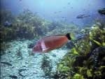
Seaweeds are important components of coastal rocky reef systems and are frequently the most visually striking organisms beneath the surface. They provide habitat for numerous small crustaceans and fish, and a food source for many grazers such as kina, paua, and other herbivores. Documenting their distribution – and understanding the physical and biological processes which determine it – is fundamental to understanding the subtidal ecology of New Zealand’s rocky reefs.
What lies beneath
- Large brown algae – seaweeds – are a dominant feature of New Zealand’s rocky reefs.
- Where they grow depends on many factors, including water clarity, wave action, and numbers of grazers, such as kina.
- A study in the subtidal waters of Dusky Sound and Stewart Island is mapping seaweed distribution to help understand the marine ecology of the area.
Reyn Naylor and Rob Stewart work in benthic fisheries and ecology at NIWA in Wellington. Dr Russell Cole is a marine ecologist based at NIWA in Nelson. This study is part of the FRST-funded programme ’Sustainability and Enhancement of Coastal Reef Fisheries of Economic and Cultural Importance’.
Teachers’ resource for NCEA Achievement Standards or Unit Standards: Biology Level 1 US90164, Level 2 AS90461, AS90769, Level 3 AS90713 See other curriculum connections at www.niwa.co.nz/pubs/wa/resources
