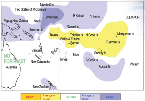
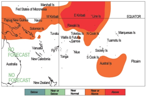
Tropical rainfall and SST outlook: July to September 2009.


During July – September 2009, a region of suppressed convection is likely in the southwest Pacific encompassing Tokelau, the Marquesas, and the Northern Cook Islands. Below average rainfall is expected for those areas. Near to below average rainfall is expected for Tuvalu, Samoa, Wallis & Futuna, the Society Islands and the Tuamotu Archipelago. Near normal rainfall is forecast for Niue. Enhanced convection is likely along the Equator extending from Western to Eastern Kiribati, and in the area around Papua New Guinea and the Solomon Islands, as well as the Southern Cook Islands and the Austral Islands. These regions are expected to receive near or above normal rainfall, with Western Kiribati forecast to receive above normal rainfall. No clear precipitation guidance is offered for Fiji, Vanuatu, Tonga, New Caledonia, and Pitcairn Island. The global models have shown significant shifts to near-neutral SST conditions for most of the Southwest Pacific region during the remainder of Austral winter. However, a projected increase in the near equatorial Pacific sea surface temperatures is observed in the northwest corner of the Southwest Pacific in most models. For July – September 2009, above average temperatures are forecast for Eastern Kiribati. A region of near or above average sea surface temperatures are forecast around Papua New Guinea and the Solomon Islands, Western Kiribati, the Northern Cook Islands, and the Austral Islands. Near normal SSTs are forecast for the remainder of the southwest Pacific. The confidence in the multi-model ensemble forecast skill for this seasonal rainfall outlook is moderately high for most Pacific Island countries. In the past, the average region-wide hit rate for rainfall forecasts issued in July is 64%, 3% higher than the long-term average for all months combined. The SST forecast confidence is mostly high for this period.
| Island Group | Rainfall Outlook | Outlook confidence |
|---|---|---|
| Kiribati (Western) | 20:35:45 (Above) | Moderate |
| Austral Islands | 25:35:40 (Near or Above) | Moderate |
| Cook Islands (Southern) | 25:35:40 (Near or Above) | Moderate-High |
| Kiribati (Eastern) | 25:35:40 (Near or Above) | Moderate-High |
| Papua New Guinea | 25:35:40 (Near or Above) | Moderate-High |
| Solomon Islands | 25:35:40 (Near or Above) | Moderate |
| Fiji | 30:35:35 (Climatology) | Moderate |
| Pitcairn Island | 30:35:35 (Climatology) | Moderate |
| Vanuatu | 30:35:35 (Climatology) | Moderate |
| New Caledonia | 35:35:30 (Climatology) | Moderate |
| Tonga | 35:35:30 (Climatology) | Moderate |
| Niue | 30:40:30 (Near normal) | High |
| Tuamotu Islands | 40:35:25 (Near or Below) | Moderate-High |
| Samoa | 40:35:25 (Near or Below) | Moderate |
| Society Islands | 40:35:25 (Near or Below) | Moderate |
| Tuvalu | 40:35:25 (Near or Below) | Moderate-High |
| Wallis & Futuna | 40:35:25 (Near or Below) | Moderate |
| Marquesas | 45:35:20 (Below) | Moderate |
| Cook Islands (Northern) | 45:35:20 (Below) | Moderate-High |
| Tokelau | 45:35:20 (Below) | Moderate-High |
| Island Group | SST Outlook | Outlook confidence |
|---|---|---|
| Kiribati (Eastern) | 20:35:45 (Above) | Moderate |
| Kiribati (Western) | 25:35:40 (Near or Above) | Moderate-High |
| Austral Islands | 25:40:35 (Near or Above) | High |
| Cook Islands (Northern) | 25:40:35 (Near or Above) | High |
| Papua New Guinea | 25:40:35 (Near or Above) | Moderate-High |
| Solomon Islands | 25:40:35 (Near or Above) | Moderate-High |
| Cook Islands (Southern) | 30:40:30 (Near normal) | High |
| Fiji | 30:40:30 (Near normal) | High |
| Marquesas | 30:40:30 (Near normal) | Moderate |
| New Caledonia | 30:40:30 (Near normal) | High |
| Niue | 30:40:30 (Near normal) | High |
| Pitcairn Island | 30:40:30 (Near normal) | High |
| Samoa | 30:40:30 (Near normal) | High |
| Society Islands | 30:40:30 (Near normal) | High |
| Tokelau | 30:40:30 (Near normal) | High |
| Tonga | 30:40:30 (Near normal) | High |
| Tuamotu Islands | 30:40:30 (Near normal) | High |
| Tuvalu | 30:40:30 (Near normal) | High |
| Vanuatu | 30:40:30 (Near normal) | High |
| Wallis & Futuna | 30:40:30 (Near normal) | High |
NOTE: Rainfall estimates for Pacific Islands for the next three months are given in the table. The tercile probabilities (e.g., 20:30:50) are derived from the interpretation of several global climate models. They correspond to the odds of the observed rainfall being in the lowest (driest) one third of the rainfall distribution, the middle one third, or the highest (wettest) one third of the distribution. On the long-term average, rainfall is equally likely (33% chance) in any tercile.
