Meteorologist Jon Tunster explains how we track changes in the tropical Pacific Ocean to predict whether there are El Niño and La Niña events on the horizon, and the impacts we might see from the El Niño event that is shaping up to develop over the next few months.
La Niña has only just ended, but already we are anticipating a potentially rapid flip to its opposite phase – El Niño.
La Niña and El Niño form the poles of the El Niño Southern Oscillation (ENSO), a natural variation in sea surface temperatures (SST) in the tropical Pacific, which tend to trigger a cascade of impacts influencing weather patterns around the globe.
While La Niña is characterised by colder than average sea surface temperatures in the central and eastern tropical Pacific, an El Niño event has warmer than average seas in this same region. These changes in sea surface temperatures are just the tip of the iceberg – the tropics are the global heat engine of our planet, and by disrupting the typical SST gradient across the tropical Pacific, the atmosphere usually follows suit. Normally a persistent east to west flow of wind occurs across this region, known as the trade winds. This circulation is weakened during El Niño events, and the preferred area of tropical rainfall moves away from northern Australia, Indonesia and the Philippines and instead towards the central and eastern Pacific.
Downstream of these changes in the tropics, we usually see at least some impacts on New Zealand weather patterns. ENSO only accounts for some of our weather variability, but it tends to shift the preferred areas of high-pressure systems in our region. This always happens in combination with other driving forces, meaning that one El Niño event will not precisely resemble a previous one. In a complex system like the atmosphere we cannot expect simplicity!
ENSO forecasts in a warming climate
Earth Sciences New Zealand (ESNZ), alongside international agencies such as Bureau of Meteorology (BoM, Australia) and National Oceanic and Atmospheric Administration (NOAA, USA) have recently switched to a new measure of ENSO conditions – the Relative Oceanic Nino Index (RONI). This was a necessary change for us to be able to monitor and predict the crucial east/west gradient associated with ENSO events in the context of broad warming across the global tropical oceans. Without this change, we would tend to over-detect and over-forecast El Niño events and miss all but the strongest La Niña events. You can read more about it here: Warming oceans prompt major overhaul of how we monitor El Niño and La Niña
ESNZ downloads and processes forecast data from multiple global circulation models (GCM) to support its Seasonal Climate Outlook. One way to monitor the potential onset and development of El Niño is by extracting the RONI values from these models. Figure 1 shows this, with the range of possible outcomes shaded in orange. There is a wide range in uncertainty, but also a general and rapid upwards trajectory. For context, these forecasts are presented alongside the top 5 historical El Niño events (selected from their eventual summertime values).
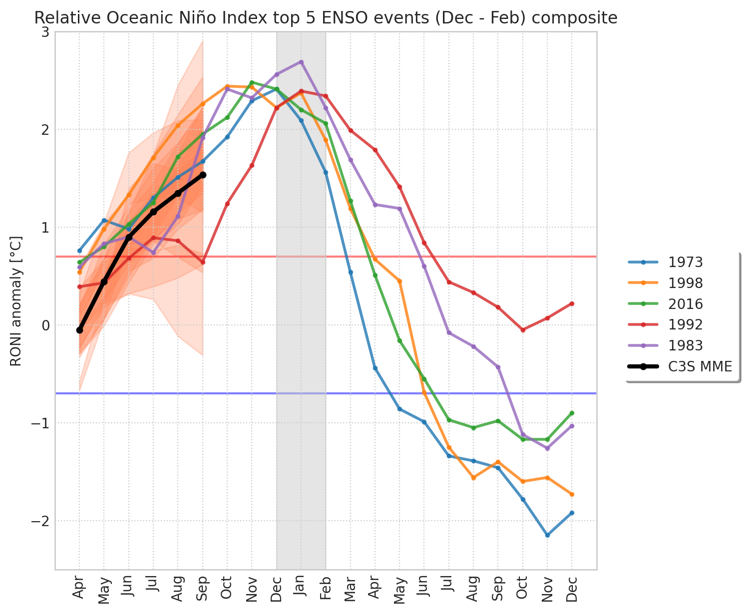
This suggests a clear consensus amongst the GCMs for an El Niño to develop this winter, and there is a >60% probability (not shown) that it will be classified as a strong event during spring. Given that the event is expected to develop further, it has potential to turn into a historic event later in the year.
El Niño in and under the ocean surface
Figure 2 shows the forecast rapid change of ocean surface temperatures spatially. While these surface temperatures are both how ENSO events are measured, and the interface through which atmospheric changes are triggered, there is a deeper – literally – story to tell. One of the most profound and striking developments over the last six months has been the eastwards transport of extremely warm waters beneath the surface of the tropical Pacific Ocean, shown in Figure 3. ESNZ identified this in spring 2025 and have been monitoring its progress and implications since the latter part of that season.
This transport of warm waters beneath the surface occurs slowly, but steadily, and can be a precursor of significant El Niño events when the water is forced to the surface. The 1997 El Niño progressed along similar lines during the early stages of its development.
Atmospheric effects
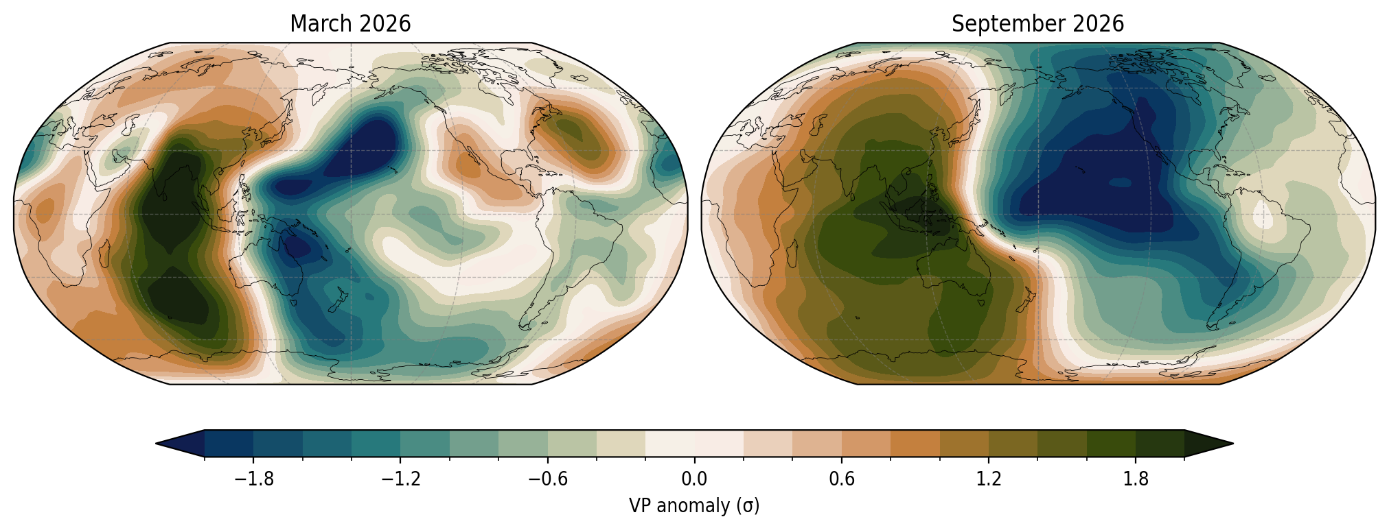
There is both a lag between these warm sub-surface waters reaching the surface, and in the atmosphere responding to changes in the SSTs. GCM forecasts are indicating an eventual very strong atmospheric response to this El Niño. Figure 4 highlights this – showing the dramatic change expected in the location of the major rising and sinking areas of air in the global tropics. This is a way of tracking impacts on the broad tropical circulation, which is what triggers all the cascading effects of ENSO weather events around the world.
Slowly sliding away from La Niña patterns through autumn
Despite the demise of La Niña in the oceans, the atmosphere maintains some lagged effects from it, and this may take a few months to peter out. We have already seen this earlier in April, with both Cyclone Vaianu and the slow-moving low-pressure system that followed it being characteristic of La Niña. Our eventual rainfall picture nationwide through the remainder of autumn is going to depend significantly on the strength and track systems like these.
Potential pattern shift in winter
We expect that El Niño conditions will be reached this upcoming winter. If the oceanic and atmospheric dominos all fall as models are currently predicting, this could lead to a switch of patterns for the country during that season.
In summer, high-pressure systems tend to migrate eastwards from the Australian Bight, into the Tasman Sea and onto New Zealand, whereas in winter their preferred behaviour shifts northwards, and they instead anchor themselves over the Australian continent itself. The forecast atmospheric response from this upcoming El Niño could strengthen this typical winter-time tendency, with perhaps even fewer high-pressure systems over the country itself, and more of them lingering to our west. This would result in a south-westerly circulation anomaly over New Zealand.
Such a pattern could bring increased rainfall to Southland, coastal Otago, and western facing areas, primarily of the South Island, but reduced rainfall for much of the remainder of the country. Dryness could become an issue entering spring for areas that see a reduction in their normal winter rainfall, such as the east of both islands and the upper half of the North Island.
A south-westerly surplus naturally raises the “cold winter?” question. If this pattern did occur, we would see occasional cold snaps, but generally lasting a few days at a time, except in inland parts of the South Island where the cold air can easily linger for much longer periods.
It has been proving increasingly difficult to produce entirely “cold winters” nationwide in New Zealand over recent decades. The last such case was in 1992* and required the Pinatubo volcanic eruption to lower global temperatures. More plausible outcomes would be, for example, a single cold month embedded in an otherwise near average season, or a cold season restricted to localised areas.
Snowstorms?
The 20th anniversary of the historic Canterbury snowstorm is approaching in June. Snowstorms are driven mostly by short term, dynamic weather drivers, though they do occur in much broader large-scale patterns that can be influenced by large-scale climate drivers like ENSO. Most of the features that contributed to the extremity of the 2006 snowstorm were small in scale, so we cannot use an expected El Niño to predict if anything similar is likely during winter.
The coldest overnight temperatures usually require existing snow cover, so if a snow event were to occur, this would skew temperatures downwards in the following nights until the snow melts. Despite this memorable snowstorm, the overall seasonal temperature anomaly in Christchurch for winter 2006 was –0.5°C, considered to be a “near average” value. This demonstrates the difference between a single memorable event, and anomalies across a whole season.
Summary
El Niño is on the way, and it could be historically strong. Global impacts should follow, in various locations and at various timescales. New Zealand is very small, and - as a famous New Zealand meteorologist once said – “weather is a mixture of pattern and chaos”. Sometimes the chaos can outcompete the pattern, and we may see surprises.
Dramatic impacts on globally important large scale weather systems – the Indian monsoon, the North Pacific storm track – look likely, and it would be very surprising if this El Niño did not impact NZ specific weather patterns. Stay up to date with the ESNZ Seasonal Climate Outlook - this currently covers to the end of June. Further updates will cover the mid and latter parts of winter, when El Niño is expected to be established.
*1992 was the last cold winter when defined against the climatology in use at the time, while maintaining a minimum threshold anomaly of -0.5C.