PDF of this article (789 KB)
Database tops 25,000 records
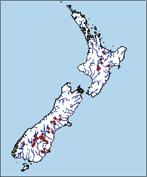
We recently added the 25 thousandth record to the New Zealand freshwater fish database (NZFFD), making this one of NIWA’s most extensive biological databases. Conceived in 1978, the NZFFD is a national repository for site-specific freshwater fish data collected by a wide variety of agencies, including NIWA, the Department of Conservation, universities, Fish and Game, environmental consultants, regional councils, and private individuals. Each record represents a unique combination of date, site, and fish species information, and national coverage is now extensive. The NZFFD has been designated as a nationally significant database and funding for its maintenance is provided through FRST.
Data from the NZFFD are primarily used to determine what species are where so we can devise appropriate management strategies that minimise the effects human activities might have on the fish. Computer models developed over the past five years from NZFFD data help us predict where certain fish species or fish communities are likely to occur, based on the location and other physical characteristics of rivers and streams. One result has been a manual on the best restoration activities to enhance fish populations. And, recently, data from the NZFFD were used to predict which native species might be affected by the spread of the invasive alga didymo.
The NZFFD can be accessed online. Registered users can perform their own searches and download data for further analysis. To learn more about becoming a registered user, visit www.niwascience.co.nz/services/nzffd
For further information, contact: Jody Richardson, 0-7-856 1746, [email protected]
Taking a new look around: DTIS debut


NIWA’s new deep-towed imaging system (DTIS), designed and built at our Wellington site at Greta Point, has had a successful debut on a Tangaroa voyage to the Graveyard group of seamounts, west of the Chatham Islands. The towed vehicle, which has a video camcorder, still camera, acoustic altimeter, and other sensors, is ’flown’ just a few metres above the seafloor. Real-time slow-scan video and altimeter data are transmitted up the 8000-m-long tow cable, while full-speed high-resolution video is recorded onto tape within the DTIS. The recovered tapes from the DTIS debut gave images of excellent clarity and detail.
For a relatively modest capital outlay, NIWA now has a deep-towed imaging system, rated to 6000 m, with much of the capability of the systems operated by the world’s most prestigious and well funded oceanographic institutes. Those systems, like the Woods Hole Argo vehicle used by Rob Ballard to find Titanic and Bismark, use very expensive fibre-optic tow cables that demand best-practice cable handling and dedicated winches. DTIS uses an existing copper cable which, although cheap and robust, cannot carry large chunks of data at speed. In a data communications breakthrough, DTIS achieves enough speed for the slow-scan video uplink and a simultaneous downlink for camcorder and lighting commands. The main advantage of the vehicles with fibre-optic cables is their real-time full-speed video that allows recording on the vessel rather than underwater. Mission duration of DTIS is limited by the length of the recording tape used in the camcorder.
During the seamounts voyage, DTIS completed over 70 video transects to 1200 m depth with impressive reliability. The winch driver used the video and altimeter data to control the vehicle by hauling in or paying out tow cable, skilfully flying the vehicle about 3 m above the seafloor. Expert ship handling was required to hold the vessel on track at just 1.5 knots, juggling often competing wind and currents while preventing the cable from going underneath the hull from its midships towing position. In the very rugged terrain found on seamounts, there were inevitable collisions with the bottom, but the chassis stood up very well. Still to be added are an advanced video lighting system that will allow filming from longer range, a precision depth sensor, and a still camera rated to 6000 m depth.
For further information, contact: Peter Hill, 0-4-386 0354, [email protected]