PDF of this article (2 MB)

Lionel Carter
There is evidence that warming following the last ice age caused major shifts in the strengths and locations of ocean currents. Will this trend continue in a warming “greenhouse” world?
An oceanographer could not live in a better place. New Zealand’s long, narrow landmass straddles two of the planet’s major water masses – Subtropical and Subantarctic surface waters. Like a rock in a river, New Zealand intercepts, disrupts and guides two of the great current systems – the warm Subtropical Gyre and the cold Antarctic Circumpolar Current (see panel below). It is this interaction between land and ocean which helps regulate our climate.
The modern ocean

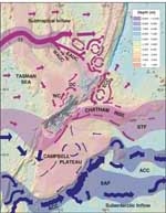
The complex patterns of modern surface currents as warm waters of the Subtropical Gyre and cold Antarctic Circumpolar Current intercept the submarine topography around New Zealand.
In the north, warm water within the Tasman Front section of the Subtropical Gyre travels from Australia to North Cape where most passes along the eastern North Island as the East Auckland Current and East Cape Current. En route, these flows spawn giant eddies that slowly stir waters to depths down to 2 km. Near Chatham Rise, the East Cape Current deflects eastward into the central Pacific.
Farther south in the Tasman Sea, westerly winds force warm water against the South Island to form the Westland Current and Southland Current. Part of the former moves through Cook Strait as the D’Urville Current. The Southland Current travels anticlockwise around the bottom of New Zealand and along the Otago–Canterbury coast. Near Banks Peninsula most of the Southland Current is diverted east by Chatham Rise. The rest continues north to mix with water from Cook Strait.
Subtropical water meets cold Subantarctic water at the 150–400-km-wide Subtropical Front. This global ocean boundary bends around the lower South Island to emerge along the crest of Chatham Rise. Not surprisingly, the mingling of waters of different temperatures within the Front produces clouds – an occur-rence that is far too common for Chatham Islanders.
Sail south of the Subtropical Front and you are in the wind-driven Southern Ocean. The Roaring Forties, Fearsome Fifties and Screaming Sixties are sailors’ colourful but apt names for the strong winds that blow out of the west. This near-constant flow of energy across an expansive ocean produces the planet-encircling Antarctic Circumpolar Current. Off New Zealand this powerful flow collides with Campbell Plateau and breaks into giant eddies that spiral northwards along the plateau margins to around latitude 48°S. There, the current peels off to continue its never-ending journey.
The turbulent ice age

Current patterns of the last glacial period, 23,000 years ago when Cook and Foveaux straits were closed by land-bridges formed as sea level fell by about 120 m. The Subtropical Gyre, represented by the Tasman Front, migrated north by about 5° latitude thus reducing the influx of warm water. The STF shifted north by a similar amount. The ACC accelerated as ice-age winds intensified.
At the peak of the last glacial period about 23,000 years ago, the oceans were a different place. Sea level fell by about 120 m as water was retained within expanding polar ice caps. Most of the continental shelf – the submarine plain surrounding New Zealand – was exposed and Cook and Foveaux straits were blocked by land-bridges. The entire coastal current system was forced 20–200 km offshore by the exposed shelf.
Expanding ice caps intensified temperature gradients between the Poles and the Equator. In the Southern Ocean, wind belts and ocean fronts migrated north. The Tasman Front moved 600 km north of its present position, thus weakening the inflow of warm Subtropical water to the North Island. Reduction in this marine heat source helped maintain or even lower the cold temperatures onshore. The Subtropical Front in the Tasman Sea also moved north, but over Chatham Rise it remained fairly steady, a prisoner of currents flowing along the flanks of the Rise.
Migration of the wind belts reinforced local wind and current systems. The Antarctic Circumpolar Current strengthened and carried more cold water to Chatham Rise and the captive Subtropical Front. Temperature differences at the Front reached 6°C. The resultant turbulence, accentuated by the wind, must have been exceptional. Off western Chatham Rise, cold waters jetted north to the normally subtropical climes of Hawkes Bay.
Post-glacial warming
As the planet gradually warmed, sea level rose with thermal expansion of the ocean and the melting ice caps. In Antarctica, rising seas fragmented ice shelves, launching flotillas of icebergs. Some sailed to New Zealand within the Antarctic Circumpolar Current, but few survived the journey past Chatham Rise. Many grounded on the 200–400-m-deep rise crest and melted in the warmer waters of the Subtropical Front.
Locally, rising seas reorganised coastal currents bringing them closer to shore as the continental shelf drowned. About 16,000 years ago, seas broke through the land-bridge across Cook Strait. Powerful tides formed and scoured the seabed creating a pathway for the D’Urville Current. Foveaux Strait was breached about 4,000 years later to provide a short cut for part of the Southland Current.
There was a general reduction in windiness. Seas presumably became less turbulent and currents slowed. Geological data confirm a slowing of the Antarctic Circumpolar Current and a reduction in cold water to central New Zealand and Chatham Rise. The Tasman Front gradually shifted south to reach its present position around 10,000 years ago. Onshore, warming air temperatures led to a shift in vegetation from grassland and scrubland to forests. Around 4,000 years ago the environment changed further. Evidence preserved in lake and ocean sediments shows marked bouts of siltation, which may be indicators of floods associated with strong signals from the El Niño–Southern Oscillation (ENSO; see panel on page 9, this issue).
A guide for the future
Thus, we have evidence that the post-glacial warming was accompanied by large changes in oceanic and coastal currents. Increases in sea-surface temperatures of up to 6°C, migrating wind belts, and a sea-level rise of 120 m all influenced circulation patterns. Although these effects occurred over about 17,000 years, they are a guide to potential changes indicated by IPCC scenarios for the next century and beyond.
If westerly winds increase we may have a stronger Antarctic Circumpolar Current. Such a change would further isolate waters on Campbell Plateau (see pages 18–19, this issue) and increase the inflow of cold water to Chatham Rise, thus modifying the Subtropical Front and the associated cloud cover. Stronger westerlies may also enhance the influx of warm Subtropical waters to our shores. However, any increased warmth may be offset locally by wind-induced upwelling of cooler subsurface waters.
If ENSO events maintain or slightly increase their frequency and intensity, there may be further variability in coastal current patterns under the differing wind regimes of El Niño and La Niña. Likewise, winds related to stronger tropical cyclones may also alter current patterns temporarily. The accompanying rain and floods will cause unusual flows of their own. In erosion-prone areas such as Poverty Bay and East Cape, flood-waters could be so heavy with mud that upon reaching the coast they would dive to the seabed and flow down-slope, spreading mud and nutrients en route.
Two flows and a landmass
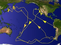
New Zealand disrupts the passage of two great current systems. The Subtropical Gyre occupies most of the South Pacific as an anticyclonic system driven by regional winds. From South America, the north arm of the gyre flows to Australia where it intensifies to form the East Australian Current. Near Sydney the flow turns east as the Tasman Front. This is the gyre’s southern arm, which intercepts Northland on the return journey to South America.
In the Southern Ocean, persistent westerly winds form the powerful Antarctic Circumpolar Current – the planet’s longest current. Covering 24,000 km in its west-to-east passage around Antarctica, it is the only current to connect all the oceans. For much of this journey the Antarctic Circumpolar Current is unimpeded, but off South America and New Zealand it is constricted by the submarine topography. The result is rapid jets and whirling eddies that are observable from space.
Lionel Carter is based at NIWA in Wellington.
