NIWA run a computer model which simulates wave heights across the Canterbury continental shelf and along the coast.
NIWA offers a more advanced wave forecast for the Southwest Pacific and Southern Ocean as a commercial service, contact Richard Gorman for further information, details at bottom onf this page.
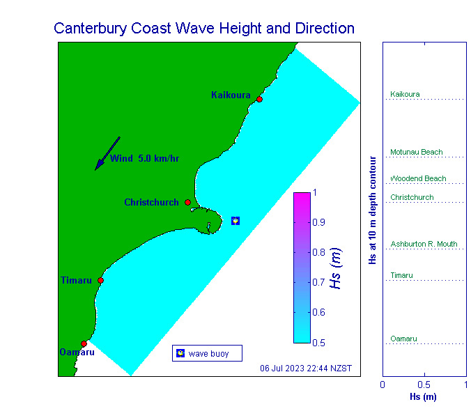
For the Canterbury model, we use a wave refraction model to simulate wave heights across the Canterbury continental shelf and along the coast. We do this by refracting deep-water waves to the coast and adding in the effect of local winds. The purpose of this modelling is to provide near real-time information on wave heights along the Canterbury coast for use by surfers, fishers and coastal planners and engineers.
We run the simulations every three hours, basing them on measured deep-water wave conditions from a wave buoy in 76-m water depth off Banks Peninsula, and on measured wind data from the climate station at NIWA Christchurch in Kyle Street.
The plots (shown at the bottom of the page) give significant wave height, which is the average of the highest 33% of the waves in a recorded sample. We use this because it gives a statistically robust measure of the larger incoming waves, which are more important than smaller waves in many applications. For example, it is the larger storm waves that cause most damage in terms of coastal erosion, coastal flooding and maritime activities.
The plot on the left shows near real-time wave height and direction across the Canterbury continental shelf and along the coast. This has been simulated by refracting deep water waves to the coast using a wave refraction model and adding in the effect of local winds. The plot on the right shows wave heights along the coast at the 10-m depth contour which is typically between 0.6 and 2 km from the shoreline but much less than this at Kaikoura and farther north and around Banks Peninsula. These plots are updated every three hours unless there are communication dropouts.
The model utilises wave statistics (significant wave height, Hs, and mean period, Tz) from the latest 20-minute wave sample collected from the NIWA wave buoy off Banks Peninsula and a time-matched recording of hourly average wind speed from the NIWA Christchurch climate station. The wind speed given in the plot incorporates a factor of two to convert wind speed at the recorder site to equivalent wind speed offshore. The arrows signifying incoming waves are scaled in length to wave height. The time indicated is the start time of the 20-minute wave sample used. The time of the wind speed sample may vary from this slightly.
Further information about the model
Acknowledgement
This model was developed with funding from Environment Canterbury.
