The name of this programme, “Mā te haumaru o ngā puna wai o Rākaihautū ka ora mō ake tonu” acknowledges an ancestor of Wairewa Rūnanga, who are partners in the research. It translates to “By keeping the water of Rākaihautū safe the water will survive eternally”. Rākaihautū was an ancestor who was said to traverse the South Island, digging and naming lakes as he travelled. You’ll also see us use a shortened version of this name: “Mā te haumaru o te wai”, which means “By keeping the water safe”.
A national flood inundation hazard and risk assessment for Aotearoa New Zealand
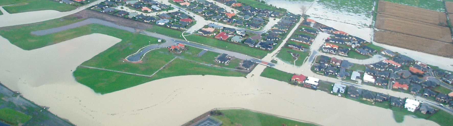
In Aotearoa, our regular flood clean-up bills are topped only by much less frequent earthquakes. And with a warming climate and rising seas, flooding is expected to become more severe and more frequent.
This five-year NIWA-led research programme will develop a system to map flood hazard consistently across the whole country. It will reveal how our flood risk might change over the next 100 years because of changes to rainfall and sea level from climate change, as well as due to land-use changes.
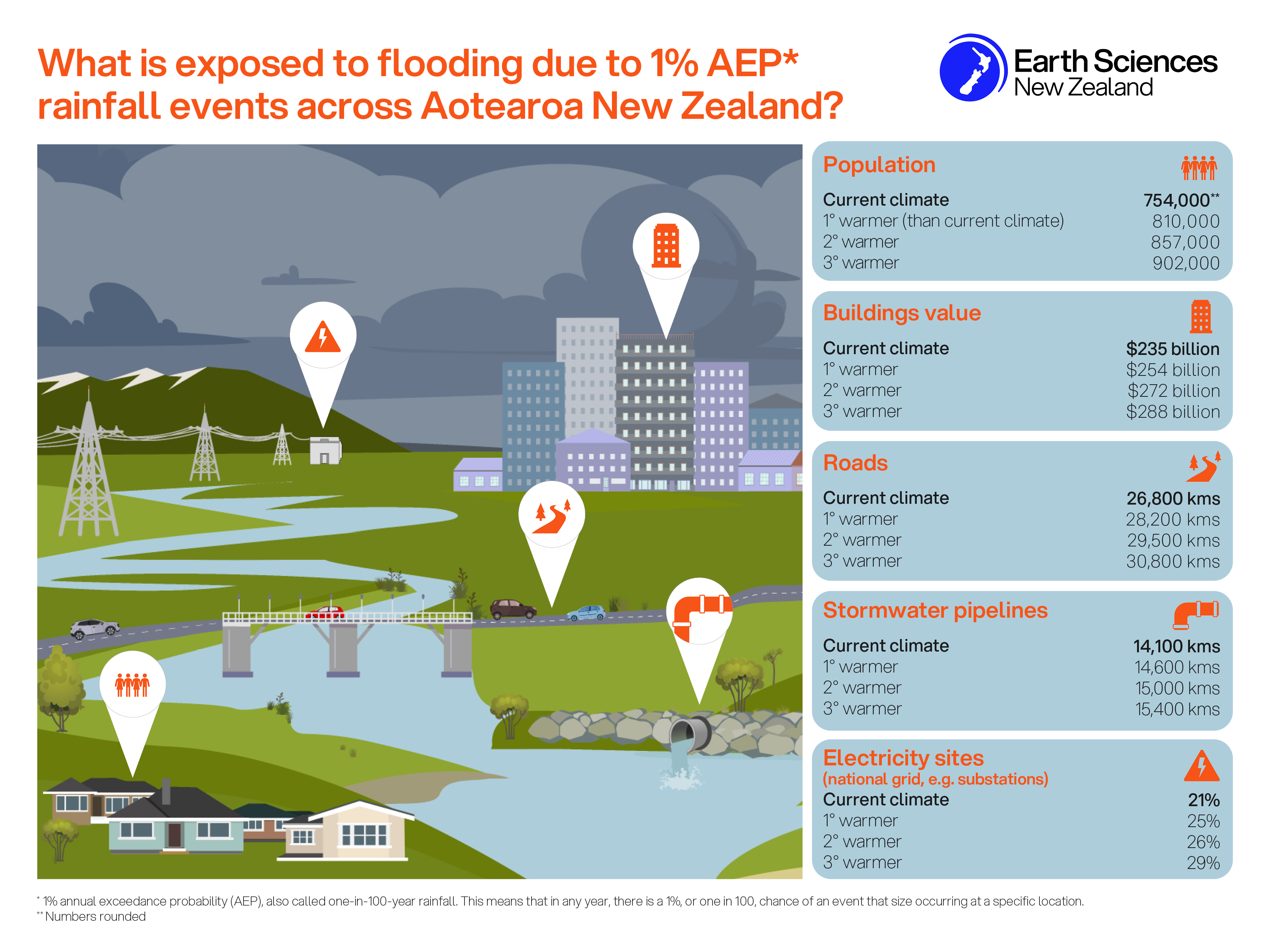
One of the outcomes will be the first, nationally-consistent, flood inundation hazard and risk assessment for Aotearoa New Zealand. Mapping national flood risk under current and future climates will provide a valuable resource for people undertaking future risk assessments.
The research will investigate flood exposure according to type of land use, as well as risk to buildings, infrastructure networks, and long-term sustainability of flood schemes or defences.
It will also provide a forum for researchers, iwi, stakeholders and government to discuss flood inundation hazard and risk and to co-develop strategies for a more flood resilient Aotearoa. The team will also work with case study communities to understand how they react to increasing flood hazard due to climate change and to help them develop adaptation strategies.
Programme overview:
Working with Māori
Vision Mātauranga is at the heart of this research programme. The researchers are working with the hapū of Wairewa Rūnanga, Kāti Mako and Ngāti Irakehu, to explore their knowledge of flooding and to develop a plan to enhance the sustainability of their taonga. The programme outputs will also feed into the development of the Wairewa Rūnanga climate change strategy. The knowledge developed here will provide a template for other hapū and iwi to use to understand their flood risk.
Quantifying and communicating uncertainty
There is inherent uncertainty in the science underpinning many parts of this programme. In addition, making informed decisions today that account for future uncertainty while providing communities with homes and facilities they need is a pressing challenge for society. An overarching theme across this research programme will focus on uncertainty, and specifically quantifying and communicating uncertainty. This will be led by Matthew Wilson of the University of Canterbury, who helped develop the models used in UK national flood assessments.
Research aims:
Research aim 1: National flood mapping
Led by Emily Lane, NIWA
This part of the project will result in the development of a flood database containing consistent flood hazard maps for a range of Annual Exceedance Probabilities (AEP) covering every catchment in the country. This will include considering the effects of climate change on both the intensity, as well as temporal and spatial structure of the storms, through analysis of new high-resolution weather modelling and observations. Results will be validated against historical floods in specific catchments.
Objectives of research aim 1:
- Set up a semi-automated system that can develop consistent flood hazard maps for all Aotearoa New Zealand under current and future climates.
- Collate historic flood photos and information.
- Investigate hybrid machine-learning/hydrodynamic approaches to flood modelling.
Research aim 2: Flood risk to the built environment
Led by Ryan Paulik, NIWA
RA2 will see the development of a dynamic flood risk model that will assess flood exposure and risk at national to local (i.e., floodplain) levels.The researchers will co-design risk analysis methodologies with leading flood risk researchers, public and private sector flood disaster risk managers. This will deliver a flexible, user-configurable modelling tool to support socioeconomic flood risk assessment in Aotearoa.
Objectives of research aim 2:
- Support the development of more nationally-consistent decisions about land use, infrastructure, urban and rural development, nationwide disaster risk reduction and adaptation to flooding, reducing future liability issues.
- Develop models and tools that support risk-informed decision-making on present-day and future mitigation actions for flood prone communities.
- Deliver consistent New Zealand-wide information about land use, building and infrastructure risk to flood impacts.
Research aim 3: Societal vulnerability to cascading events
Led by Paula Blackett, Urban Intelligence
This part of the programme aims to develop useful, useable, scalable, and transferable sets of knowledge, processes and practices for understanding flood risks in a way that accounts for cascading impacts and complexity.
Objectives of research aim 3:
- Understand the social dimensions of flooding.
- Use case studies and a systems-mapping approach to study how flooding affects hapū and communities, directly and indirectly.
- Explore how cascading events (multiple large flooding events or combinations of flooding with other exacerbating factors) can affect tolerance to flooding, especially under climate change.
Research aim 4: Reducing flood risk and adapting to change
Led by Iain White and Silvia Serrao-Neumann, Waikato University.
By bringing together river managers, iwi, government agencies, financial institutions and stakeholders, the researchers will ensure that the programme outputs are fit-for-purpose (useable, useful and used), explore adaptation options under changing climate conditions, and design new ways to make decisions, taking into account climate and socio-economic projections.This will allow organisations to develop policies, processes, and funding mechanisms to support a fair and transparent transition to a more flood-resilient country.
Objectives of research aim 4:
- Bring together stakeholders to co-produce knowledge, engage with public and private sectors and develop policy and best practice guidance.
- Explore how to use flood mapping to reduce the vulnerability of current and future developments to flooding.
- Investigate how housing market signals may be used to enhance resilience to flooding.
Programme outputs
Flood hazard data for NZ flood plains by region
You can access the data used to create this dashboard at DataHub.
Exposure assessment data – 1% AEP rainfall flooding
You can access the exposure assessment data (national and regional) here.
Please note that this is part of a larger dataset that will be released later this year alongside a report into the exposure modelling methodology.
Societal vulnerability to cascading events - case study reports
Research papers
Afsari-Bajestani, S., Serrao-Neumann, S., Hanna, C. & Fu, X. (2024) Dealing with uncertainty in flood risk management and land use planning decisions: Insights from Aotearoa New Zealand. Climate Risk Management 46: 100666
Anshuka, A., Fu, X., & White, I. (2025). High water, high stakes: A global review of flood risk and housing price effects. International Journal of Disaster Risk Reduction, 122 (10545), 105452
Bailey-Winiata, A.P., Gallop, S.L., White, I. et al. (2024) Looking backwards to move forwards: insights for climate change adaptation from historical Māori relocation due to natural hazards in Aotearoa New Zealand. Reg Environ Change 24, 80
Booker, K.L., White, I., Fu, X. & Wilson, M. (2025) Modelling urban growth for long-term planning under future climate uncertainty: a systematic review and decision pathway. Cities 167; 106310
Cretney, R. and White, I. (2024) ‘A shared vision and a common enemy’: Reframing narratives of crisis and climate politics through Aotearoa's COVID-19 response and recovery, The Geographical Journal, e12611
Cretney, R., White, I., & Hanna, C. (2024). Navigating adaptive futures: analysing the scope of political possibilities for climate adaptation. Kōtuitui: New Zealand Journal of Social Sciences Online, 1–22
Djanibekov, U., Polyakov, M., Craig, H., & Paulik, R. (2024). Flood impacts on agriculture under climate change: The case of the Awanui Catchment, New Zealand. Economics of Disasters and Climate Change, 8(2), 283-316
Fu, X., Bell, R., Junqueira, J., White, I, and Serrao-Neumann, S. (2023) Managing rising residual flood risk: A national survey of Aotearoa-New Zealand, Journal of Flood Risk Management 16 (4) e12944
Hanna, C., Cretney, R. and White, I. (2022) Re-Imagining Relationships with Space, Place, and Property: The Story of Mainstreaming Managed Retreats in Aotearoa-New Zealand. Planning Theory and Practice, 23 (5): 681-702
Hanna, C., Wallace, P. and Serrao-Neumann, S. (2025) Evaluating riverine flood policy: Land use planning trends in Aotearoa New Zealand. Environmental Science & Policy 164, 104006
Hanna, C., White, I., Cretney, R. et al. Beyond retreat: Land–seascape legacies of change and continuation. Ambio 54, 1199–1212 (2025)
Hanna, C., White, I. and Glavovic, C. (2021) Managed Retreats by whom and how? Identifying and delineating governance modalities, Climate Risk Management, 31: 100278
Harang, A., Lane, E.M., Bosserelle, C., et al. Flood Hazard in Aotearoa New Zealand Under Current and Future Climates. Geoscience Data Journal, 13(3): e70083
Huddleston, P., Smith, T., White, I. and Elrick-Barr, C. (2022) Adapting critical infrastructure to climate change: a scoping review, Environmental Science and Policy, 135: 67-76
Huddleston, P., Smith, T., White, I. and Elrick-Barr, C. (2023) What influences the adaptive capacity of coastal critical infrastructure providers? Urban Climate, 48, 101416
Junqueira, J., Serrao-Neumann, S, and White, I. (2022), Using Green Infrastructure as a social equity approach to reduce flood risks and address climate change impacts: A comparison of performance between cities and towns, Cities, 104051
Junqueira, J., Serrao-Neumann, S, and White, I. (2020) A systematic review of approaches for modelling current and future impacts of extreme rainfall events using green infrastructure, Journal of Cleaner Production, online first, 125173
Li, C., Xue, Y., & Fu, X. (2024). Urban built environment and flood ramifications: evidence from insurance claims data in Miami, Florida. Journal of Planning Education and Research, 0739456X241276854
Munshi, D., Cretney, R., Kurian, P., Morrison, S. L., & Edwards, A. (2024). Culture and politics in overlapping frames for the future: Multi-dimensional activist organizing and communicating on climate change in Aotearoa New Zealand. Organization, 31(3), 477-495
Nguyen, M., Wilson, M.D., Lane, E.M., Brasington, J, & Pearson, R.A. (2025) Quantifying uncertainty in flood predictions due to river bathymetry estimation. Hydrology and Earth System Sciences Discussions 2024, 1-26
Nguyen, M., Wilson, M.D., Lane, E.M., Brasington, J., Pearson, R.A. (2025) Quantifying uncertainty in flood predictions in fixed cartesian flood model due to arbitrary conventions in grid alignment. Water Resources Research, 61(5)
Paulik, R., Hosse, L., Pelmard, J., Bosserelle, C., Harang, A., Powell, J., Pearson, R., Carey-Smith, T., Lane, E. M., Scheele, F., Zorn, C., Wotherspoon, L., & Foster, L. (2026). Evaluating New Zealand's building risk to fluvial and pluvial flooding. Discover Hazards 2:2
Paulik, R., Wild, A., Zorn, C., Wotherspoon, L. (2022). Residential Building Flood Damage: Insights on Processes and Implications for Risk Assessments. Journal of Flood Risk Management, 15(4) e12832.
Paulik, R., Wild, A., Zorn, C., Wotherspoon, L., Williams, S. (2024). Evaluation of residential building damage for the July 2021 flood in Westport, New Zealand. Geoscience Letters 11(15)
Paulik, R., Wild, A., Zorn, C., Wotherspoon, L., Williams, S. (2024). Residential building damage assessment and evaluation for the July 2021 flood in Westport, New Zealand. Geosciences Letters 11, 15
Paulik, R., Williams, S., Popovich, B. (2023). Spatial Transferability of Residential Building Damage Models between Coastal and Fluvial Flood Hazard Contexts. Journal of Marine Science and Engineering 11(10), 1960
Paulik, R., Zorn, C., Wotherspoon, L. and Sturman, J., (2023). Modelling national residential building exposure to flooding hazards. International Journal of Disaster Risk Reduction, p.103826
Paulik, R., Zorn, C., Wotherspoon, L. (2023). Evaluating the spatial application of multivariable flood damage models. Journal of Flood Risk Management. E12934
Paulik, R., Zorn, C., Wotherspoon, L. (2024). Residential building and sub-building level flood damage analysis using simple and complex models. Natural Hazards 120; 13493–13512
Paulik, R., Zorn, C., L Wotherspoon. (2023). Evaluating the spatial application of multivariable flood damage models. Journal of Flood Risk Management 16(4) e12934
Paulik, R., Zorn, C., Wotherspoon, L., Harang, A. (2024). Model parameter influence on probabilistic flood risk analysis. International Journal of Disaster Risk Reduction 100: 104215
Pearson, R., Harang, A., Cattoën, C., Bosserelle, C., Measures, R., Wilkins, M., Smart, G., Lane, E. (2023). GeoFabrics 1.0.0: An Open-Source Python package for automatic hydrological conditioning of Digital Elevation Models for flood modelling. Environmental Modelling and Software
Pozo, A., Wilson, M., Katurji, M., Cagigal, L., Méndez, F.J., and Lane, E. (2025). Characterising Local Flood-Inducing Heavy Rainfall Through Daily Weather Types and Large-Scale Climatic Patterns: Aotearoa New Zealand Study Case. Internation Journal of Climatology, e8762
Serrao-Neumann, S., White, I., Dean, S. M., Paulik, R., Sleight, B., Stori, F. T., Wilson, M. D., & Lane, E. M. (2023). The need to reconfigure consistency and variability to best manage changing flood risks in Aotearoa-New Zealand. Journal of the Royal Society of New Zealand 54; 473-490
White, I. and Lawrence, J. (2020) Continuity and change in National RiskScapes: a New Zealand perspective on the challenges for climate governance theory and practice, Cambridge Journal of Regions, Economy and Society, rasaa005.
Williams, J. H., Vu, H. N., Paulik, R., Zorn, C., & Wotherspoon, L. (2025). Expert‐Derived Flood Damage Curves for Critical Infrastructure Network Components. Journal of Flood Risk Management, 18(2), e70045
Xue, Y., Fu, X., & Li, C. (2025). Mismatch between flood risk and insurance protection: A county-level analysis in the contiguous United States. Environment and Planning B: Urban Analytics and City Science, 52(3), 756-760
Policy briefs and flood awareness booklet
Members of the Environmental Planning team at the University of Waikato released a series of policy briefs that describe the major insights and recommendations from this project. Additionally, Becoming Floodwise: Awareness and action for Aotearoa is an easy-to-read booklet that draws on findings from the research programme and explains essential flood concepts. Inside, you’ll find explanations of flood hazard, risk and likelihood, practical checklists for individuals and policymakers, and guidance on using tools like the National scale flood hazard viewer. Download and read these below.
Books/chapters
Lawrence, J., B. Mackey, F. Chiew, M.J. Costello, K. Hennessy, N. Lansbury, U.B. Nidumolu, G. Pecl, L. Rickards, N. Tapper, A. Woodward, and A. Wreford, 2022: Australasia. In:Climate Change 2022: Impacts, Adaptation, and Vulnerability. Contribution of Working Group II to the Sixth Assessment Report of the Intergovernmental Panel on Climate Change (S. Dean, Contributing Author).
Conference presentations
Conference presentation at the Australasian Coasts & Ports 2021 Conference "BG-Flood: A GPU adaptive, open-source, general inundation hazard model", Cyprien Bosserelle, Emily Lane, Alice Harang.
Practice roadshow May 2022 - Uncertainty Science: webinar. Wilson, M.
Roadshow November 2022 – Uncertainty Science - overview and discussion. Wilson, M., & NIWA.
Working together:
There are many partners contributing to this research programme. The research is funded through the Ministry for Business, Innovation and Employment’s Endeavour Fund.
Researchers:
- NIWA
- Manaaki Whenua Landcare Research
- University of Waikato
- University of Canterbury
- University of Auckland
- University of Bristol (UK)
- University of Saskatchewan (Canada)
- Deliberate
- Weather Radar New Zealand
- Neo Leaf Global Ltd
- WSP
- Tonkin & Taylor
Central and local government: We’re working with a variety of central and local government organisations including:
- Ministry for the Environment
- Land Information New Zealand (LINZ)
- Department of Internal Affairs
- Auckland Council
- Greater Wellington Regional Council
- Otago Regional Council
Industry: We’re also working with a number of industry organisations and businesses, including the banking and insurance sectors.