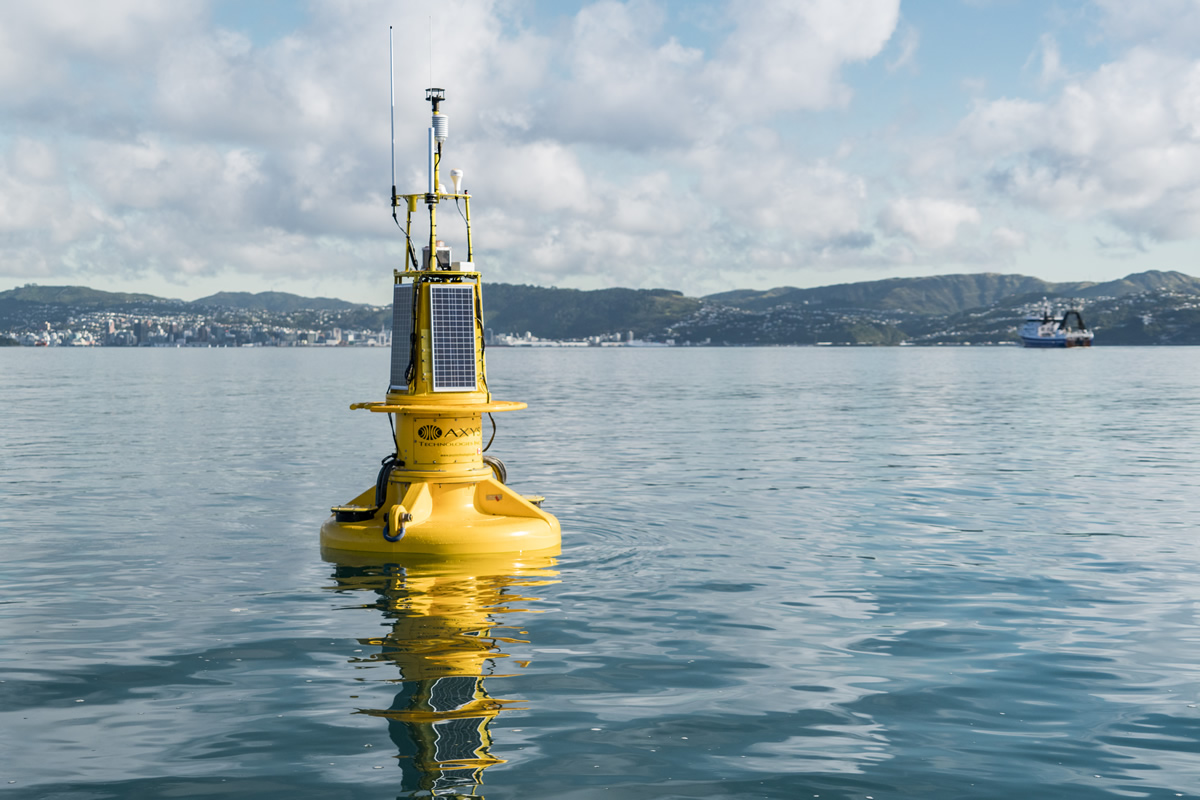
A sophisticated buoy has been deployed in Wellington Harbour to “phone home” information about currents, waves and water quality in the harbour.
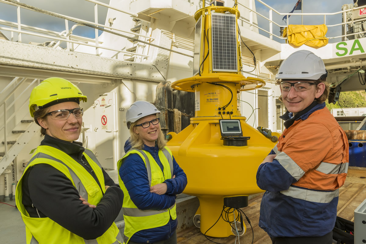
The buoy, named WRIBO (Wellington Region Integrated Buoy Observations), was deployed in early July south-east of Matiu/Somes Island by NIWA’s flagship research vessel Tangaroa.
Part of a joint project between NIWA and the Greater Wellington Regional Council (GWRC), WRIBO delivers realtime data on currents, waves, salinity, temperature, oxygen, chlorophyll, ocean acidification and wind.
NIWA coastal physicist Dr Joanne O’Callaghan says WRIBO will greatly enhance understanding of the factors affecting the health of Wellington Harbour. One of its key roles will be to monitor plumes from the Hutt River that wash into the harbour after heavy rain. These plumes carry sediments and nutrients from the Hutt catchment to the harbour. Water quality instruments observed an algal bloom after ex-tropical cyclones Debbie and Cook.
“The interim buoy that has been deployed in the harbour since September last year has shown some big responses in surface salinity and currents. Ocean salinity, measured in practical salinity units (psu), is typically around 35 psu. After the ex-tropical cyclones (Debbie, Cook and Donna) in Autumn this year, surface salinity decreased to 10 psu for several days," says Dr O'Calaghan.
“Without the surface instrument these harbour responses to river flows would have been missed completely. From other research, short-lived events from river flows can modify flows in a system for several weeks to a month. So sediment or nutrients that come into the harbour from rivers may impact the harbour health for much longer than previously thought.”
Wellington Harbour not well studied previously
Wellington Harbour is a body of water that had not been well studied previously, but WRIBO changes this.
“Long-term observations and associated science in the coastal ocean has tended to focus on one or two regions – Otago and the Hauraki Gulf.”
“Many studies in harbours or coastal ocean have been for specific commercial work with observations of a month or so to address the minimum modelling requirements. Over the past five years I have been progressing a research theme around river plumes in the Hauraki Gulf and Doubtful Sound – as an idealised natural laboratory – and now Wellington Harbour.”
River plumes are only a few metres thick, so there is now an instrument just beneath the surface to measure them. There are also a number of instruments in the water column attached to the buoy to enable scientists to analyse harbour response at various depths. Waves and currents move sediments during storms so there is an instrument near the seabed and two more through the water to know the size of the impact.
Having access to detailed data over a number of seasons will allow Dr O’Callaghan to drill down on how long events of several days, such as the autumnal ex-tropical cyclones, affect Wellington Harbour.
“By understanding what these timescales are, GWRC can think about how to manage and set limits for the incoming rivers. It is thinking about the system as a whole – a source-to-sea approach. There are a number of water quality parameters being measured and there will be regular water sampling at the buoy to make sure the data is calibrated and of best quality.”
And that quality data will be phoned home immediately by WRIBO.
“The buoy makes a phone call to a computer and sends back data of up-to-date conditions in the harbour. This means we don’t have to wait for good weather to collect the data, which is never easy in Wellington.”
The buoy stands three metres tall and is powered by solar panels and manufactured by AXYS technologies in Canada. Constructed by NIWA’s mooring technician Mike Brewer over several weeks at NIWA's Wellington site, WRIBO is the most complicated of its kind in New Zealand waters.
“One of the mooring challenges is making sure it stays in place during large storms in the windy city,” says Dr O’Callaghan. “Three days after deployment, one of the windiest storms in two years occurred. We have lost moorings in Wellington Harbour before in large storms, so it’s quite worrying, but it’s a wait-and-see approach once all the planning and actual deployment has occurred. WRIBO stayed in place in early July, which was a huge relief.”
Dr O’Callaghan says it’s not only inclement weather WRIBO has to manage. Wellington Harbour is obviously very busy, with ferries, commercial shipping, commercial and recreational use.
“The buoy is appropriately lit and sends signals directly to vessels entering or leaving the Harbour. The location was chosen to be out of the shipping lanes, not an easy feat in Wellington, but also to be in a useful location.
“I think the wind and wave data will be most used by the various users of the harbour. Having real-time weather data for fishing and sailing will be sought after.”
GWRC coastal scientist Dr Claire Conwell says this is the beginning of a dedicated water quality monitoring programme for Wellington Harbour and the region’s coastal marine area.
“This information will help us to make links between the freshwater and marine environments, and to assess the impacts on water quality of land-based activities,” Dr Conwell says.
“A key focus for us is to also make the data accessible, so we’ll be working with the NIWA team after the buoy is deployed to get the data streaming via our respective websites. In the long run, we’d like to see this sit alongside other data from buoys across New Zealand, forming part of a national network.”
[This feature appeared in Water & Atmosphere 19]