NIWA freshwater scientists have launched a groundbreaking initiative that is transforming mapping of freshwater environments.
The team of hydro-ecological modellers have developed digital networks (DNs) that map connections between river and lake systems for multiple purposes. These networks provide essential data that supports policymaking, environmental planning, and scientific research. The data can be used in classifications, models, and simulations, helping to shape more effective water management strategies.
Unlike traditional networks that primarily focus on large rivers, the innovative approach can incorporate smaller streams, ditches, and ephemeral channels—water pathways that only flow temporarily. The level of detail in a DN is essential; while biophysical modelling may require intricate flow pathways inside and outside river channels, policy initiatives may only need key river segments. This flexibility means that different DN characteristics—such as density, alignment, and coverage—can be tailored to suit various applications.
NIWA Programme Leader, Doug Booker said, “We have been developing automated methods to generate version-controlled, spatially consistent, and functionally precise DNs using high-resolution Digital Elevation Models (DEMs), including those derived from LiDAR, which is increasingly available across New Zealand.” said NIWA Environmental Flows Programme Leader, Doug Booker.
LiDAR (Light Detection and Ranging) is a remote sensing technology that uses laser light to measure distances and create precise, three-dimensional maps of environments. It works by emitting laser pulses, which bounce off objects and return to the sensor. The time it takes for the light to return is used to calculate the distance to the object.
“By integrating mapped features such as headwater locations, sinkhole locations, and lake polygons from Land Information New Zealand (LINZ) TopoMaps, we have improved DN accuracy and applicability,” he said.
Traditionally each segment of a DN has been labelled according to its position using the Strahler ordering system. This system starts at one for headwaters segments and increases by one in the downstream direction when two segments of the same order meet. Major innovations of this research include introduction of a multi-coloured labelling system and extending Strahler ordering to use non-positive numbers to recognise ephemeral flow pathways upstream of river channels. The new labelling system helps freshwater managers by showing where water flows over land into which rivers and will also ensure comparability of networks regardless of location or resolution.
The NIWA team recently presented their findings to the Regional Council Geospatial Special Interest Group, receiving strong interest. Users particularly liked the new system because it allows users to dynamically adjust DN density, ensuring a single DN can serve multiple purposes with consistency and efficiency.
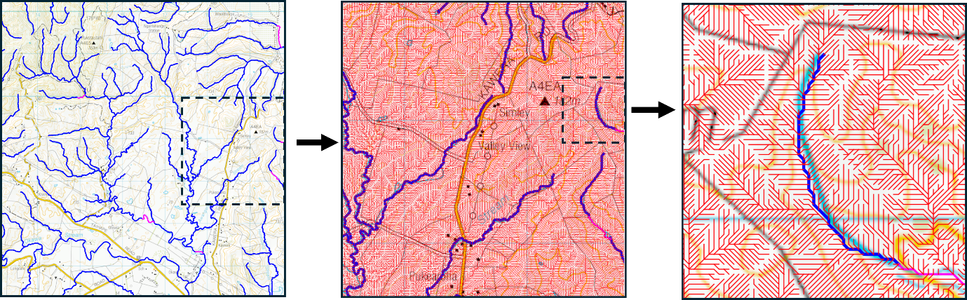
Below is an example of a generated network showing more detail as the image is increasingly magnified from left to right:
- Blue lines resembling river channels seen on 1:50k cartographic maps but generated using LiDAR-derived DEMs for greater accuracy.
- Purple lines indicate ephemeral channels downstream or river sinkholes.
- Red lines highlight ephemeral flow pathways upstream of river channels on an 8m resolution grid.
This pioneering work marks a significant advancement in freshwater management, ensuring that digital networks remain adaptable, precise, and fit for a range of environmental and policy needs.