A weekly update describing soil moisture across the country to help assess whether severely to extremely dry conditions are occurring or imminent. Regions experiencing these soil moisture deficits are deemed “hotspots”. Persistent hotspot regions have the potential to develop into drought.
Facts: Soil Moisture
Across the North Island, soil moisture levels have generally decreased since this time last week. The driest soils across the North Island compared to normal for this time of the year are found from near the Auckland CBD north through to the Kaipara and Whangarei Districts. Soils are drier than normal for this time of year across western Taranaki, parts of Hawke’s Bay and much of the lower North Island south of Wanganui. Isolated pockets of wet soils for this time of year exist in the western Bay of Plenty and Far North District of Northland.
Patches of hotspots are in the southern Gisborne and Hawke’s Bay regions as well as the Kaipara District in Northland.
Across the South Island, here too soil moisture levels have generally decreased since this time last week. The driest soils across the South Island compared to normal for this time of the year are found at the top of the island, far eastern Tasman region through to the northern Marlborough, as well as the central part of the island, inland Ashburton and Selwyn Districts. The wettest soils for this time of the year are found in coastal regions between Dunedin and Oamaru.
Isolated hotspots are located in northern Marlborough region as well as in the Ashburton and Selwyn District.
Outlook and Soil Moisture
For the North Island, a subtropical low is forecast to move south and increase the threat for rain showers late Friday through to Saturday for mainly eastern parts of the North Island from central Hawke’s Bay to Northland. Rainfall, if any, is expected to be generally light, less than 10 mm. However, some locations in east coastal Northland may receive near or more than 20 mm of rain by Saturday night.
Meanwhile, an onshore southeast flow around the aforementioned low will likely bring rain showers from Gisborne to central Hawke’s Bay Saturday through to Monday where eastern slopes of the ranges may receive 25-50 mm of rain over the two-day period. Significantly less amounts are likely elsewhere in these regions. Thereafter, unusually strong high pressure for this time of year is forecast to build in, resulting in little or no rainfall for the remainder of the week.
For the South Island, light and spotty rain showers are possible Friday and Saturday as a weak cold front dissipates. Thereafter, atypically strong high pressure for this time of year is forecast to dominate the island. Consequently, except for the odd patches of showers, dry weather is expected for the island Monday through to Friday of next week.
For the North Island, despite the weekend rainfall over eastern parts, soil moisture levels are likely to decrease for most, if not all, of the island. The most rapid and significant loss of soil moisture will occur over the central and lower portion of the island where hotspot development is likely by late next week, particularly over the Taranaki region and south of the Central Plateau.
For the South Island, the lack of rain combined with above normal mean air temperatures, long days and a strong sun will mean soil moisture will rapidly decrease over most or all the island. Consequently, soils will dry island-wide with new hotspots developing along with an expansion of existing ones.
It should be noted that there is excellent agreement among global models that strong high pressure will remain in control for several days beyond this outlook period. Therefore, this marks the beginning of prolonged spell of below normal or well below normal rainfall along with above normal temperatures that will persist to at least to the end of the month for the vast majority of the country, with the South Island likely bearing the brunt of the dryness.
Background:
Hotspot Watch a weekly advisory service for New Zealand media. It provides soil moisture and precipitation measurements around the country to help assess whether extremely dry conditions are imminent.
Soil moisture deficit: the amount of water needed to bring the soil moisture content back to field capacity, which is the maximum amount of water the soil can hold.
Soil moisture anomaly: the difference between the historical normal soil moisture deficit (or surplus) for a given time of year and actual soil moisture deficits.
Definitions: “Extremely” and “severely” dry soils are based on a combination of the current soil moisture status and the difference from normal soil moisture (see soil moisture maps)
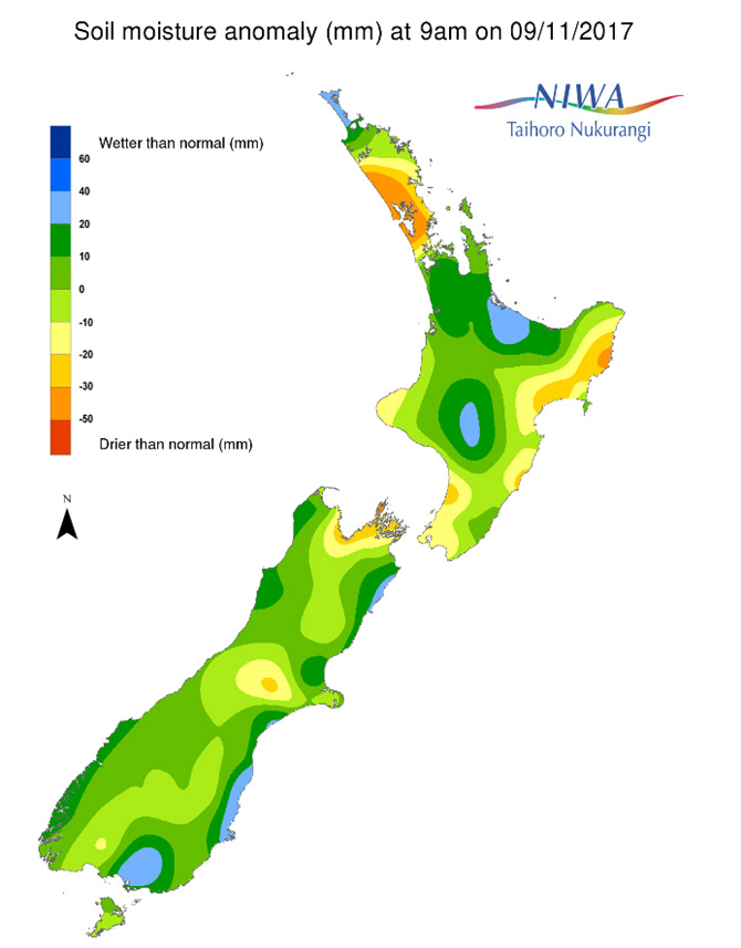
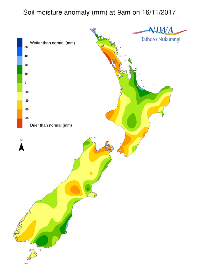
Soil Moisture Anomaly Maps, relative to this time of year. The maps show soil moisture anomaly for the past two weeks.