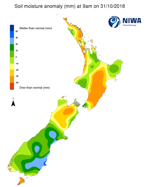
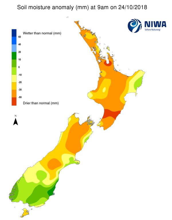
A weekly update describing soil moisture across the country to help assess whether severely to extremely dry conditions are occurring or imminent. Regions experiencing these soil moisture deficits are deemed “hotspots”. Persistent hotspot regions have the potential to develop into drought.
Facts: Soil Moisture
North Island As of 31 October 2018, recent rainfall has continued to be below normal for a majority of the island, excluding far western Northland, parts of the Coromandel, northern Bay of Plenty, and coastal Wanganui and Rangitikei where recent rainfall has been above normal.
After a prolonged period of dry and settled weather, lower than average pressure brought rainfall to much of the island during the period 26-30 October. Many locations recorded over 30 mm of rain. The driest areas in the past 15 days were Napier City and eastern Hastings that recorded less than 5 mm of rain.
With the recent rain, the soil moisture has generally improved across the island since last week. However, the soils are still drier than normal for the time of year in eastern Northland, western Auckland, western Waikato, western Taranaki, as well as Hawke’s Bay, central and southern Manawatu-Wanganui and Wairarapa.
South Island The rainfall patterns have continued to be mixed. Central Marlborough along with the West Coast and parts of Southland have experienced well below average rainfall for this time of year. The most anomalously wet areas were found along the lower east coast, in central and southern Canterbury and parts of Otago. The driest area in the last 15 days was central Hurunui District with less than 20 mm of rain recorded.
Currently, the most anomalously dry soils are found in the north, especially in interior Marlborough where the soil moisture is well below average for this time of year. The most anomalously wet soil is found near Dunedin.
Outlook and Soil Moisture
The previously developed hot spots have either vanished or decreased significantly in size and strength due to the recent rainfall. The only current hotspots are found in small areas near Napier and southern Hastings District.
A somewhat active weather pattern is expected to continue over the next seven days with several fronts impacting the country.
North Island A front may bring locally moderate to heavy rainfall to parts of the island on Thursday 1 November. The heaviest rainfall is expected in the higher elevations of Gisborne along with the Wellington and Manawatu-Wanganui Regions, but at lower elevations most accumulations will remain below 15 mm.
Another front may bring showers (generally less than 10 mm) mainly to the south and west on Saturday 3 November. In addition, an area of low pressure may bring a few showers to the upper North Island on Monday and Tuesday (5-6 November).
Weekly rainfall for most locations across the island is likely to be in excess of 15-20 mm. With moderate rainfall expected, soil moisture levels will likely remain largely unchanged for much of the North Island, except for Hawke’s Bay and Wairarapa where the soil moisture levels are likely to decrease at least slightly.
South Island A front will move up the island on Wednesday (31 October), resulting in rainfall and cooler temperatures. Rainfall will generally be less than 10 mm but could exceed 15 mm in Fiordland and in Tasman.
An area of low pressure south of the country will bring a threat for heavy rain to the West Coast on Friday evening and Saturday with rainfall of 50-100 mm possible. The rain should ease on Sunday, but several more millimeters are possible. Temperatures well above average for this time of year should bring summerlike weather to the eastern South Island during the beginning of next week.
As a result, soil moisture levels will increase along and west of the divide, but may decrease elsewhere as rainfall totals are expected to remain below 20 mm.


