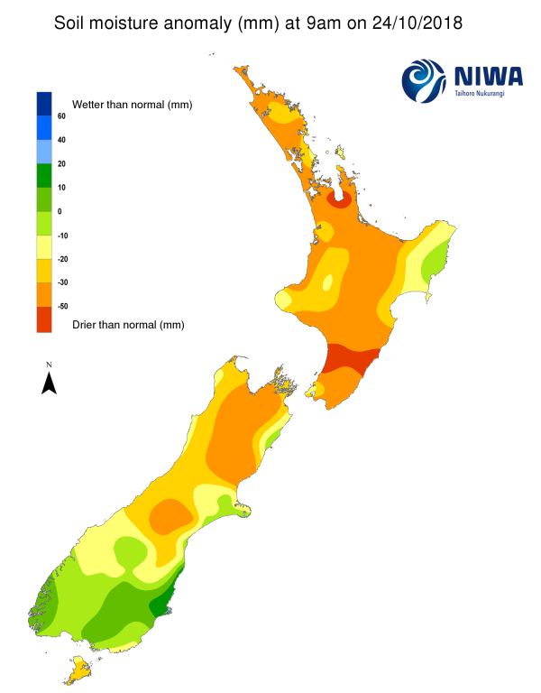
A weekly update describing soil moisture across the country to help assess whether severely to extremely dry conditions are occurring or imminent. Regions experiencing these soil moisture deficits are deemed “hotspots”. Persistent hotspot regions have the potential to develop into drought.
Facts: Soil Moisture
North Island As of 24 October 2018, rainfall has continued to be below normal or well below normal for a majority of the island, excluding East Cape and the Tauranga area where rainfall has been near normal. The drier than normal pattern has generally been a continuation of what was observed during September and the first three weeks of October. The driest area in the past 15 days was the eastern Tararua Region where less than 5mm of rain have fallen since 8 October.
Consequently, soils are drier than normal for the time of year in the majority of the North Island, excluding the eastern Gisborne region where the soil moisture is near average for this time of year. The most anomalously dry soils for the time of year are found in northern Hauraki, eastern Franklin, north Waikato, and western Thames Coromandel, as well as parts of Manawatu, Tararua, Palmerston North City and Horowhenua.
South Island The rainfall patterns have been mixed in the last 15 days. Parts of Queenstown-Lakes District in Otago, the Grey and Buller Districts in the West Coast, northeastern Marlborough, and the Waimate District in southern Canterbury experience well below average rainfall for this time of year, while the rest of the island had near normal rainfall. The driest areas in the last 15 days were in parts of Waimate, Central Otago, and Queenstown-Lakes where many locations recorded less than 10mm rainfall.
Currently, the most anomalously dry soils are found in parts of Hurunui, Mackenzie, and the Waimakariri Districts of Canterbury, along with eastern Tasman and western Marlborough. The most anomalously wet soil was found in the Clutha District in Otago.
Outlook and Soil Moisture
In the last seven days, hotspots have developed in the southern Hurunui and central Mackenzie Districts in Canterbury, eastern Hastings and eastern Central Hawke’s Bay Districts, along with western Manawatu District.
After a prolonged period of higher than normal pfalseressure and settled weather, a more active weather pattern is expected over the next seven days.
North Island A front building over the South Island on October 24 will weaken but bring showers (generally less than 10 mm) to the North Island on Thursday and Friday (October 25-26).
Low pressure in the Tasman Sea could bring moderate to heavy rainfall to parts of the island during the upcoming weekend and the beginning of next week. The heaviest rainfall is expected in the eastern Bay of Plenty, western Northland, Taranaki and the lower west coast where isolated rainfall amounts may exceed 75 mm in the seven-day period ending Tuesday night. Weekly rainfall for most locations across the island is likely to be in excess of 25 mm.
With significant rainfall, soil moisture levels will increase for much of the North Island, except for parts of Hawke’s Bay and eastern Gisborne where the soil moisture levels are likely not to experience significant change.
South Island A southerly change will move up the island on Wednesday and Thursday (October 24-25), resulting in rainfall and cooler temperatures. The heaviest rainfall is expected in higher elevations of Fiordland and the lower West Coast region. Rainfall totals to the east of the Alps will be lower, but isolated areas may see rain totals exceeding 30 mm in the 48-hour period.
Low pressure in the Tasman Sea will bring the threat for showers, primarily to eastern and northern areas later this weekend and especially the first half of next week, however rainfall is expected to be less than what occurs beforehand.
As a result, soil moisture levels are likely to increase along and west of the divide and should stay constant or slightly decrease elsewhere.


