A weekly update describing soil moisture across the country to help assess whether severely to extremely dry conditions are occurring or imminent. Regions experiencing these soil moisture deficits are deemed “hotspots”. Persistent hotspot regions have the potential to develop into drought.
Soil Moisture
North Island
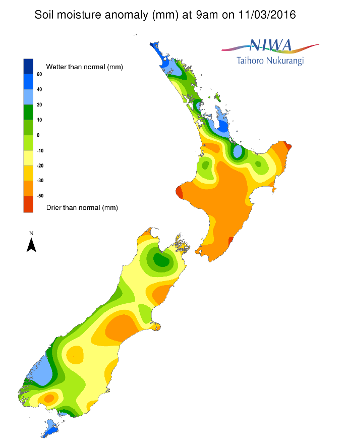
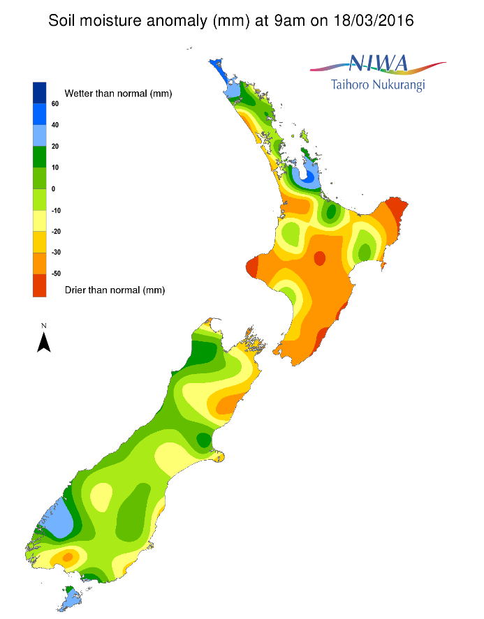
Across the North Island, soil moisture levels have generally decreased slightly when compared to this time last week. The most noticeable decreases were observed in Gisborne and far northeastern Bay of Plenty. Steady decreases continued in Taranaki and from central Waikato through extreme western Northland. Soils trended wetter in west coastal Manawatu-Whanganui. The wettest soils compared to normal for this time of the year are found along the Coromandel Peninsula and in northern Northland while the driest are found from Wairarapa to just south of Napier, extreme northeastern Gisborne, central Waikato, and western Taranaki.
Much of the North Island has below to much below soil moisture for this time of the year. Hotspot areas remain present across southern and western Hawke’s Bay, much of Wellington-Wairarapa, interior Manawatu-Whanganui, much of Taranaki, western and central Waikato, northeastern Bay of Plenty, and northeast coastal Gisborne. Over the last week, hotspot activity has expanded across southern Gisborne. A new, narrow hotspot has developed across southwestern Northland. Hotspot relief has occurred in recent days across east coastal Manawatu-Whanganui. With little rainfall in the forecast into early next week, hotspot areas may expand in the short term. However, locally heavy rainfall late next week may work to reduce or eliminate some of the hotspot areas.
South Island
Across the South Island, soil moisture levels have generally increased when compared to this time last week. The most notable increases occurred in Central Otago, and lower and middle Canterbury. Slight decreases occurred in Hurunui, Kaikoura and northern and eastern Marlborough. The driest soils compared to normal for this time of the year are found in coastal Hurunui, Kaikoura, far northern Tasman, far northern Marlborough, and central Southland.
On the South Island, hotspot areas remain present in northern Canterbury and far northern Marlborough. A few small hotspot areas have been eliminated in central and southern Canterbury. A small hotspot in northeastern Queenstown Lakes has also been eliminated over the last week. Over the next week, hotspot activity is forecast to remain the same or improve in Canterbury and Marlborough. Periods of heavy rain across the far south, West Coast, and eventually the far north through the week will prevent new hotspot development in those locations.
Outlook
Heavy, locally flooding rainfall affected the Coromandel Peninsula on Thursday as a moist easterly flow developed. Instances of above normal rainfall over the last week were the exception, not the rule, across the North Island. During this weekend into early next week, rainfall will continue to be mostly below average across the island. Isolated showers will be directed to the east coast on both Saturday and Sunday, specifically from the Bay of Plenty to Northland.
Some may also affect the Central Plateau; however, daily rainfall is forecast to be under 5 mm in most places. A similar regime will continue on Monday and Tuesday, with northeasterlies driving showers to exposed eastern areas (again, places that do see a shower should see less than 5 mm of rain).
The weather looks generally dry through Tuesday for much of the west coast and southern North Island. Tuesday night through Thursday, there is a risk for a slow-moving, heavier, tropical rainfall from north to south across much of the island. The storm may bring widespread rainfall of more than 10 mm with a decent likelihood for more than 25 mm. In the worst case, there may be instances of flooding and slips. Showers may linger behind the system to round out the work week. Many places on the North Island may see above normal rainfall over the next week, with localized rainfall amounts to 125 mm by next Friday.
After a week that featured near normal rainfall for much of the South Island, the next week will bring the opportunity for much above normal rainfall that can lead to flooding, especially in Fiordland and along the West Coast. Saturday and Sunday will be very wet in both of the aforementioned locations, with daily rainfall between 25 and 75 mm. Rainfall will be less heavy in the Tasman and Nelson regions on Saturday with totals up to 10 mm in the lowlands and in excess of 25 mm across the higher terrain.
On Sunday, rain will progress across the rest of Southland and into interior Otago with totals generally less than 10 mm. Rain will continue along the West Coast and Fiordland on Monday and Tuesday as well as in far southern Southland. In the Wednesday-Thursday timeframe, an intense low pressure system over the Tasman may produce a widespread heavy rainfall over the South Island, with the heaviest totals in the west and north.
Localized downpours may continue into Friday. The heaviest rains over the next week will be in Fiordland and the West Coast, where totals may exceed 500 mm. The least rainfall over the next week will likely be across mid-Canterbury with totals generally less than 25 mm.
Background
Hotspot Watch a weekly advisory service for New Zealand media. It provides soil moisture and precipitation measurements around the country to help assess whether extremely dry conditions are imminent.
Soil moisture deficit
Soil moisture deficit is the amount of water needed to bring the soil moisture content back to field capacity, which is the maximum amount of water the soil can hold.
Soil moisture anomaly
This is the difference between the historical normal soil moisture deficit (or surplus) for a given time of year and actual soil moisture deficits.
Definitions
“Extremely” and “severely” dry soils are based on a combination of the current soil moisture status and the difference from normal soil moisture (see soil moisture maps at https://www.niwa.co.nz/climate/nz-drought-monitor/droughtindicatormaps).
Soil moisture anomaly maps
Pictured below are soil Moisture Anomaly Maps, relative to this time of year. The maps show soil moisture anomaly for the past two weeks.
Last Hotspot Watch
This is the last of NIWA's Hotspot Watch for the 2015/16 summer - we hope you have found it useful. Hotspot FTW.