A weekly update describing soil moisture patterns across the country to show where dry to extremely dry conditions are occurring or imminent. Regions experiencing significant soil moisture deficits are deemed “hotspots”. Persistent hotspot regions have the potential to develop into drought.
Facts: soil moisture
It was a dry week for the North Island as a ridge of high-pressure lingered overhead. Most areas recorded no rainfall at all, while temperatures have been well above average, contributing to greater evapotranspiration. The most rainfall in the North Island was recorded in Wellington, where only 11 mm fell. This led to significant soil moisture decreases across the entire North Island. The driest soils across the North Island, when compared to normal for this time of the year, are found in the Waikato and western coastal Northland. The wettest soils for this time of year are found in South Taranaki and southern Manawatū-Whanganui.
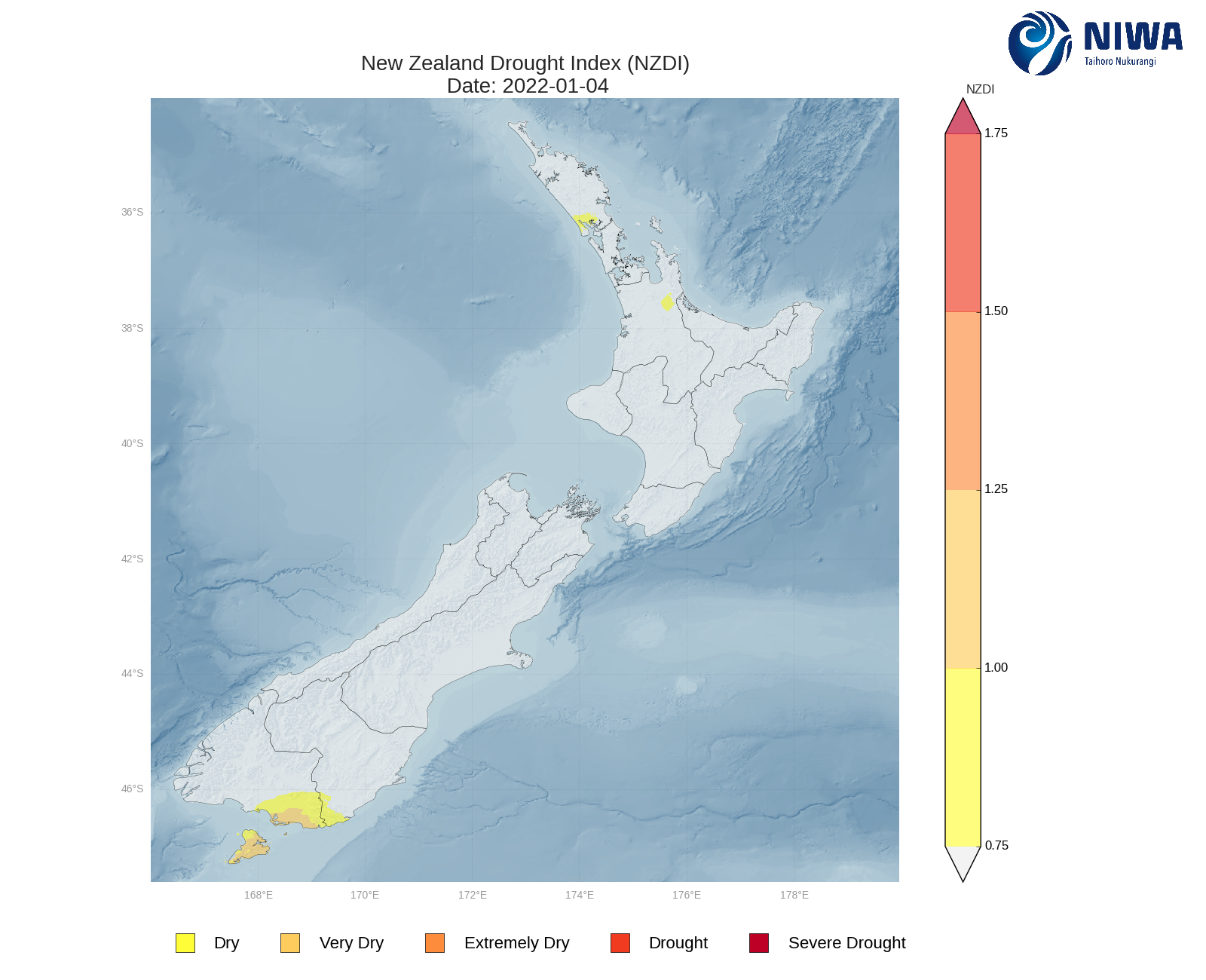
Hotspots are currently located in central Waikato, northern Hawke’s Bay, parts of Northland, and parts of Auckland. The New Zealand Drought Index (NZDI) map below shows that dry conditions have emerged in northern Kaipara Harbour and eastern Waikato.
In the South Island, a burst of rain delivered up to 20 mm to parts of Fiordland, Otago, and the Canterbury, with some isolated totals near 50 mm. Milford sound observed 47 mm on 31 December. A weak front then brought a few showers to parts of Southland, Otago and Canterbury on 4 January, with Lauder collecting 17 mm of rainfall. Elsewhere was largely dry. This resulted in soil moisture decreases for much of the South Island. The driest soils in the South Island, when compared to normal for this time of year, are found in Southland and Raikura/Stewart Island. The wettest soils for this time of year are found in the eastern Canterbury near Kaikoura.
Hotspots are currently located in southern Southland, including parts of Gore, and Clutha. The New Zealand Drought Index (NZDI) map below shows that dry-to-very dry conditions are Raikura/Stewart Island, southern Southland and southern Clutha.
Outlook and soil moisture
In the North Island, a band of showers look to push across Auckland and Northland on Friday (7 January), easing to isolated showers on Saturday. Sporadic, isolated showers then look to develop for western areas on Monday. Another weak front may then bring more scattered showers to western and southern areas next Wednesday (12 January). Overall, it looks like another drier-than-normal week, although there are more chances of brief rainfall compared to last week. Most areas will see less than 1 mm over the next week. Parts of Wellington, including the Tarauras, may see isolated totals as high as 30-50 mm.
Due to the expected rainfall in the next week, soil moisture levels are likely to decrease for most of the North Island. All currently hotspots are likely to expand. A small hotspot may emerge in southern parts of Hawke’s Bay.
In the South Island, isolated showers look to affect the Canterbury, Marlborough, parts of the northern West Coast and Tasman/Nelson on Thursday and Friday (7 January). These should clear by the weekend, but sporadic, light showers then look to develop over the West Coast and Fiordland, tending to scattered showers later in the weekend. Isolated showers may persist for some western, southern and eastern areas into Tuesday and Wednesday. Overall, it looks like another largely drier-than-normal week for the South Island. Some elevated parts of Fiorldland, the Southern Alps and Otago may pick up isolated rainfall totals as high as 50-75 mm over the course of the next week. Parts of the eastern Canterbury may receive up to 10 mm, with the foothills possibly up to 25 mm.
Due to the expected weekly rainfall, soil moisture levels will either remain the same or decrease. The hotspots in Southland and Clutha may expand slightly.
Background:
Hotspot Watch: a weekly advisory service for New Zealand media. It provides soil moisture and precipitation measurements around the country to help assess whether extremely dry conditions are imminent.
Soil moisture deficit: the amount of water needed to bring the soil moisture content back to field capacity, which is the maximum amount of water the soil can hold.
Soil moisture anomaly: the difference between the historical normal soil moisture deficit (or surplus) for a given time of year and actual soil moisture deficits.
Definitions: “Extremely” and “severely” dry soils are based on a combination of the current soil moisture status and the difference from normal soil moisture (see soil moisture maps).
Hotspot: A hotspot is declared if soils are "severely drier than normal" which occurs when Soil Moisture Deficit (SMD) is less than -110 mm AND the Soil Moisture Anomaly is less than -20 mm.
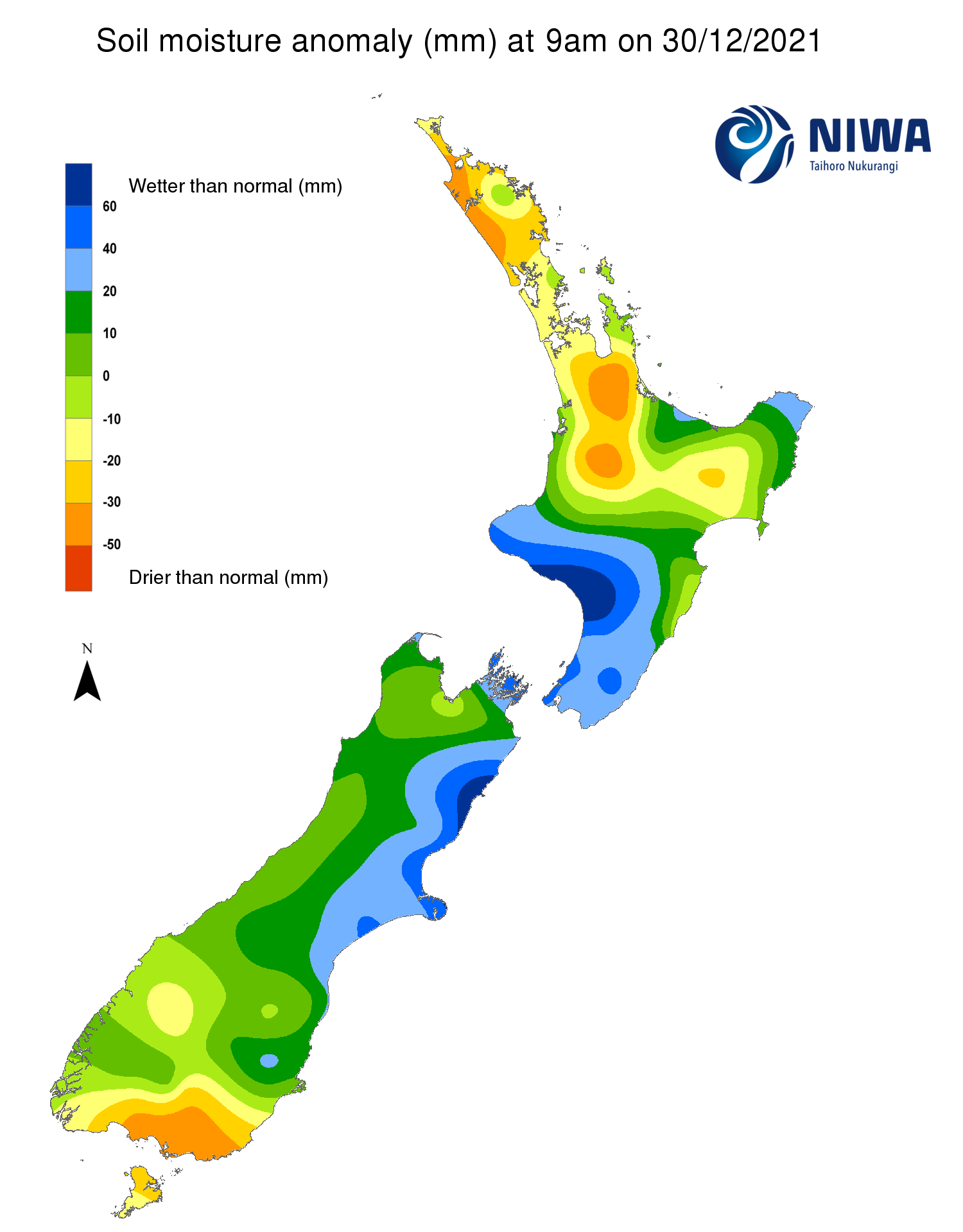
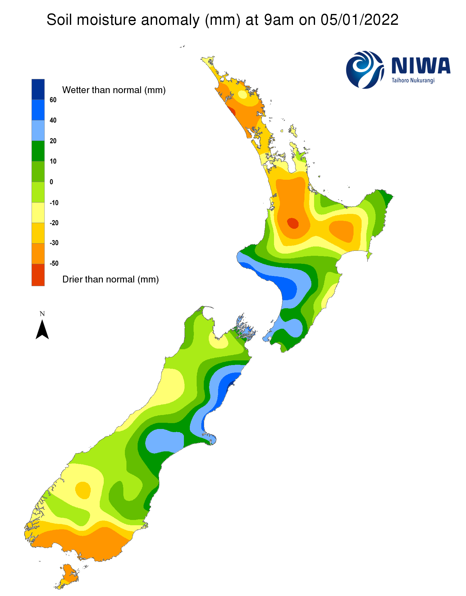
Pictured above: Soil Moisture Anomaly Maps, relative to this time of year. The maps show soil moisture anomaly for the past two weeks.
As of 4 January, the New Zealand Drought Index (NZDI) map below shows that dry-to-very dry conditions are located in parts of Southland, Raikura/Stewart Island and Clutha. In addition, dry conditions have emerged in northern Kaipara Harbour and eastern Waikato. Please note: some hotspots in the text above may not correspond with the NZDI map. This difference exists because the NZDI uses additional dryness indices, including one which integrates the rainfall deficit over the past 60 days. Changes are therefore slower to appear in the NZDI compared to soil moisture anomaly maps that are instantaneously updated.