PDF of this article (3 MB)

Malcolm Green
Waves at the edge of an estuary can cause surprisingly large amounts of sediment to disperse over quite long distances: what are the implications for the estuary ecosystem?

When out in a boat in the middle of a large estuary, we see wide expanses of deep water and we feel strong tidal currents. When we walk along the shoreline of the same estuary, however, we wade through shallow water that creeps sluggishly up and down the intertidal flats. Is there a connection between the two?
Certainly, the waves that break upon the estuarine shoreline are generated by wind blowing over the open expanses of water in the middle of the estuary, so that’s one kind of connection. This can be inferred from an interesting phenomenon: when the tide drops and sandbanks in the middle of the estuary start to emerge from the water, waves along the downwind shoreline get smaller. What is happening is that the emerging sandbanks break up the “fetch” of water over which the wind blows to generate waves. In effect, the wind has to start all over again building waves every time it encounters an emerging sandbank (see diagram and “Waves in shallow water” in Water & Atmosphere 10(2)).
Wave action and the turbid fringe
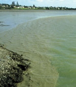
What happens when the waves arrive at the estuary shoreline? Just like on an open coast, the waves stand up as they enter shallow water and then eventually break. Back-and-forth water movement underneath waves (the wave orbital motions) can stir up (suspend) bed sediments into the water. In the estuary, this happens in the so-called turbid fringe (see “Formation of the estuarine turbid fringe” below), named because estuary bed sediments are usually muddy and the water turns brown and turbid when they are stirred up by waves.
The outer edge of the turbid fringe coincides with the depth at which wave orbital motions touch down on the bed. The inner edge of the band coincides with the depth at which waves have spent all their energy and decayed away to virtually nothing. This might be right at the shoreline, in which case “fringe” is accurate, or it might be somewhat offshore, in which case it is really a “turbid band”.

As the tide goes up and down in the estuary, the turbid fringe moves across the intertidal flats, expanding and contracting in a complicated dance that is controlled by the interaction between such factors as wave height, water depth, shape of sandbanks, and gradient of the intertidal flats. For instance, at low tide the fringe can be tiny or nonexistent since emerging sandbanks in the middle of the estuary prevent downwind wave growth, which switches off the turbid fringe. And at high tide it may be too deep for waves to penetrate down to the bed anywhere except right at the estuarine shoreline, which will also cause the fringe to contract.
Dispersal of sediments
Now we come back to connections. It turns out that the estuarine turbid fringe can stray from the intertidal flats where it is born, into the deep heart of the estuary. We know this from experiments in Manukau Harbour, Auckland, in which we have identified remnants of a turbid fringe moving down a deep tidal channel into the interior of the estuary on an outgoing tide. This has an interesting implication: sediments on an intertidal flat might be widely dispersed throughout the estuary by becoming suspended in a turbid fringe that then escapes down a deep tidal channel. If the sediments are contaminated, then such dispersal could spread environmental harm. On the other hand, dispersing sediments may not always be such a bad thing. For instance, sediments brought down in rainstorms can dump on and smother shellfish beds (see “Sediment dumps in estuaries” in Water & Atmosphere 10(4)). However, under the action of a turbid fringe, the dumped sediments may be picked up and dispersed in time to limit damage – a kind of natural defence against sediment attack. Either way, this connection between the centre and the edges of the estuary has implications for the health of the estuarine ecosystem.
We don’t understand a lot about how turbid fringes get dispersed in the wider estuary. Part of the reason is that our numerical tidal-current circulation models, which we use to visualise and understand circulation patterns in the estuary, are weakest around the edges where we have wetting and drying. This means that they don’t depict processes in those areas very accurately. We are presently working on improving our understanding of processes at work in the turbid fringe by making wave, current and suspended-sediment measure-ments. Our experiments are expanding our knowledge of connections and what these mean to the health of the estuary.
Teachers: this article can be used for NCEA Achievement Standards in Biology (1.3, 2.4, 2.5) and Science (1.6, 3.5). See other curriculum connections at www.niwa.co.nz/pubs/wa/resources
Malcolm Green is based at NIWA in Hamilton.
How much sediment is suspended in the turbid fringe?
Consider a round estuary, 10 km wide, with a 10-m wide turbid fringe running all the way around the edge. The area of the interior of the estuary is about 500 times that of the turbid fringe. If sediment is suspended to about the same height above the bed and the suspended-sediment concentration (SSC) is the same in both regions, then there are about 2 orders of magnitude (100 times) more sediment suspended in the interior than in the fringe. On the other hand, if the SSC is two orders of magnitude greater in the fringe, then there are about equal amounts of sediment suspended in the two regions. The latter is more like reality: SSC in turbid fringes is significantly higher than in the interior, sometimes more than two orders of magnitude greater.
Conclusion: there might be times when as much or more sediment is suspended in the turbid fringe as in the rest of the estuary.

Formation of the estuarine turbid fringe
Cross-section of waves stirring up a turbid fringe. Interestingly, the same kind of thing happens on ocean beaches, but we are less aware of it for a couple of reasons. Firstly, the open-coast turbid fringe extends way past the seaward limit of the surf zone to depths of 10–20 m or more under the larger ocean waves. Secondly, the seabed is typically not as muddy as in an estuary, hence the fringe is not as muddy and is therefore harder to see. Note, there is still plenty of sand in suspension in the water, but it doesn't cloud the water like mud does, and it also stays closer to the seabed.
