The problem
Rapid response is crucial after a hazard event, such as when a major earthquake strikes. In September 2010 and again in February 2011, two devastating earthquakes (M7.1 and M6.3 respectively) hit the Christchurch region, causing billions of dollars of infrastructural damage and the loss of more than 180 lives.
These earthquakes, as well as M6.3 and M6.0 aftershocks in June 2011 and December 2011, respectively, ruptured a complex network of previously unknown faults hidden beneath North Canterbury. After the devastating February earthquake, it was recognised that far more information was needed about these faults, their location, and behaviour if Christchurch and its residents were to best understand the seismic future of the region.
The solution
Following the earthquakes, twelve separate Short Term Recovery projects, largely funded by the Ministry of Science and Innovation (MSI), and coordinated by the Natural Hazards Research Platform (NHRP) were established in March 2011 to inform Christchurch's recovery. One of these projects - Short Term Recovery Project 2: Offshore Faults – was undertaken by a team comprising NIWA and University of Otago ocean geologists.
More information about the Natural Hazards Research Platform
The aim of the Project was to improve our understanding of the wider faulting and geological context of the earthquakes, and also to determine whether active submarine faults capable of producing large (M6 or more) earthquakes exists beneath Pegasus Bay, off Banks Peninsula. This would help recovery authorities through an on-going assessment of earthquake hazard in the area.
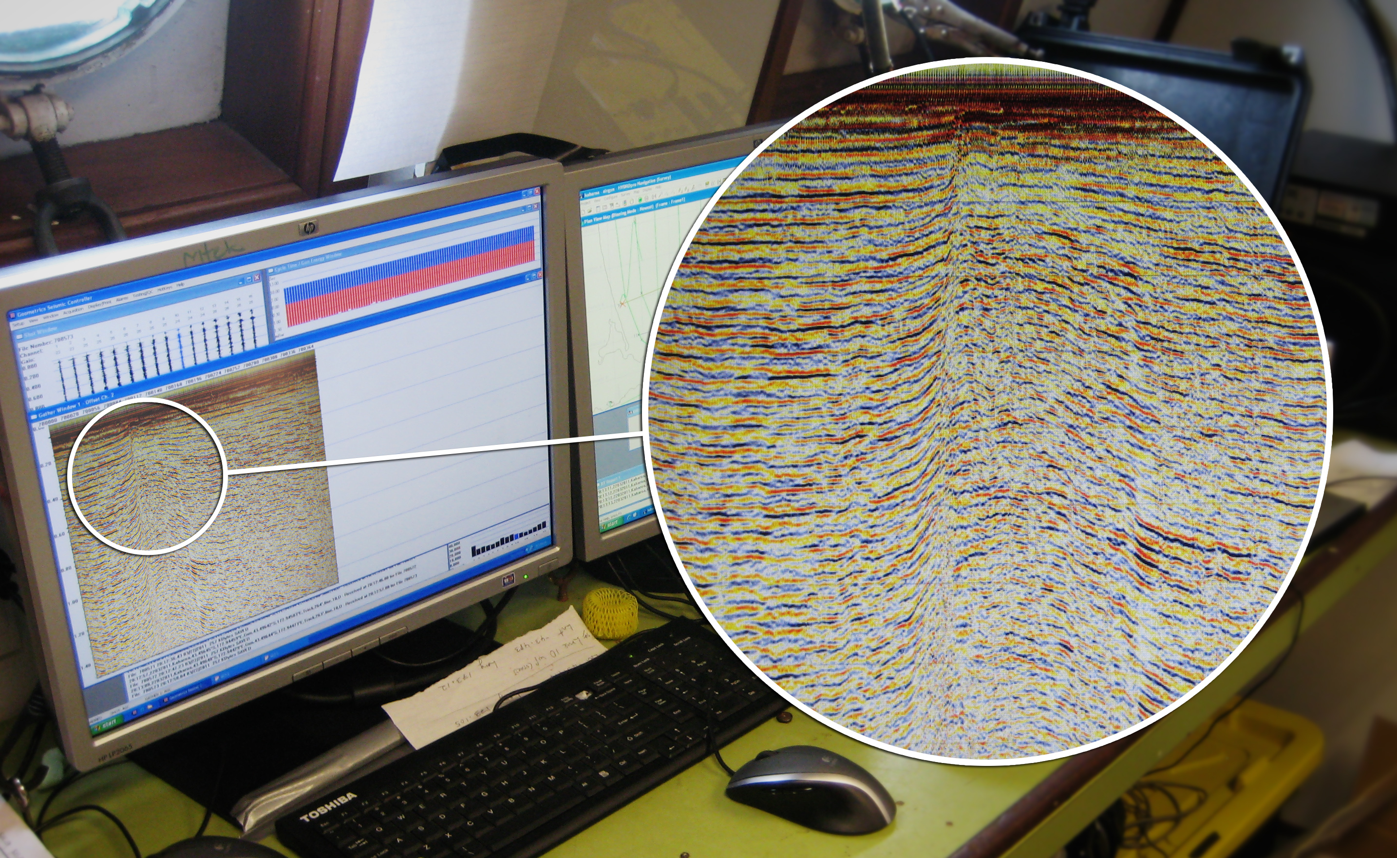
To achieve this, new marine geophysical data, capable of showing faults up to 1.5km below the seabed of Pegasus Bay, was collected and analysed.
The survey took 7 days to complete and was undertaken aboard the RV Kaharoa, NIWA's coastal research vessel. Airgun seismic data along 280km of tracks was collected, as well as 430 km of high-frequency seismic data, extending to about 40 km east and north of Christchurch. Additionally, 530 km of complementary open file oil company seismic data were available from the same region.
The result
The Christchurch survey increased our understanding of earthquakes in the region, and will contribute to a longer-term understanding of seismic hazards in Canterbury. It revealed a previously-unknown offshore fault east of Kaiapoi, and confirmed that offshore faults have very low activity rates, implying that they generate earthquakes very infrequently.
At the time of the survey, the aftershock sequence was limited largely to areas on land and was not propagating onto offshore faults. The earthquake sequence, however, has now propagated offshore with the large M6.0 December 23, 2011 aftershock and many subsequent aftershocks in the southern part of Pegasus Bay.
More detail
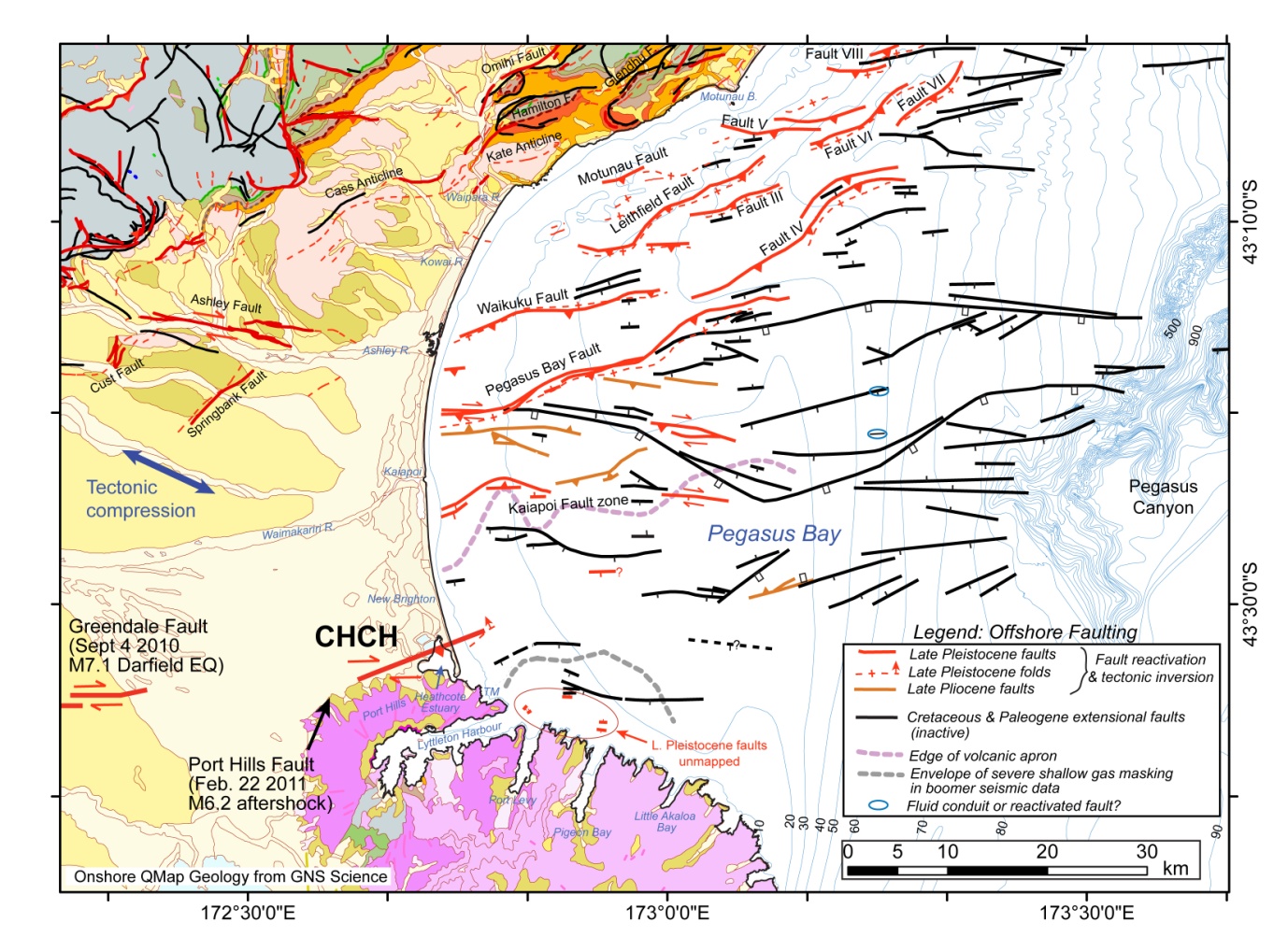
The survey revealed that faults over 35 million years old, which are found in a regional deformation which affects large areas of the eastern South Island, are widely distributed through Pegasus Bay.
The faults are predominantly south-dipping* and up to 70 km in length. They trend E-W, for the most part, and are up to 1.5 km below the seabed.
In North Canterbury, part of this ancient fault system has been reactivated and overprinted by active deformation occurring as part of the Pacific-Australian plate boundary zone. This deformation extends up to 30 km offshore beneath Pegasus Bay, and includes at least 11 major faults, with evidence of renewed activity mainly in the last 1 million years.
Most of this faulting is concentrated beneath the northern part of the bay, but newly-recognised, very weak deformation appears to extend southward to the northern coast of Banks Peninsula.
Most of the active faults are reactivated faults from the older system. The major faults range in length from about 10 to 38 km, and are thought to be capable of producing earthquakes of magnitude M6.4 to M7.2. Estimated vertical rates of faulting are very low in the north of the bay (~0.05-0.28 mm/yr), and extremely low (<0.01-0.07 mm/yr) in the south of the bay. These rates indicate that earthquakes are likely to have very long recurrence intervals, of the order of 10,000 years in the north, to perhaps several tens of thousands of years in the south.
There is a possible tentative association between aftershocks following the June 13th 2011 M6.3 earthquake and a small area of poorly-mapped Pleistocene faulting close to Port Levy and Pigeon Bay on Banks Peninsula. Offshore earthquakes on and since December 23 2011 lie south of the near-surface expression of the newly discovered faults offshore of Kaiapoi. Research is ongoing, in parallel with onshore geological studies by collaborators in the Natural Hazards Research Platform, to better understand seismic behaviour in the Canterbury region.
* Faults in the earth's crust are planar features (like a giant fracture but with displacement on them) that extend to depths commonly up to 15-30 km. They are three dimensional features and often are not vertical. South dipping describes the fact that most of these faults dip at an angle, with the plane facing to the south.