Summary of the 2005-06 tropical cyclone season
S Burgess, NIWA


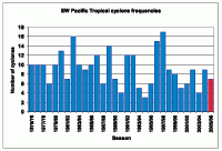
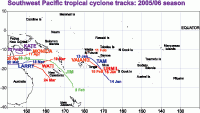
The 2005-06 Southwest Pacific tropical cyclone season had seven occurrences (east of 150°E), two less than the average number normally expected for the region in a season (Figure 1). There was also one occurrence which originated adjacent to our region – just west of 150°E. ICU tropical cyclone guidance, produced as early as September 2005, was for a normal frequency of occurrences (nine) in the Southwest Pacific. Many of the season’s occurrences affected the region west of the Date Line (tracks are shown in Figure 2), with the highest frequency of occurrences in the Coral Sea since at least 1999-2000. This was consistent with weak La Niña conditions in early 2006. There was an even spread of tropical cyclones throughout the January to March period, the last and most severe of the season (tropical cyclone Monica) being in April. Five of the Southwest Pacific region tropical cyclones (71%) reached hurricane strength, and two reached major hurricane strength (sustained wind speeds of at least 168 km/h).
'Tam' was the first tropical cyclone of the season, occurring north of Fiji on 12th January, tracking toward Tonga on the 13th, to pass west of Niue, with gale force winds. 'Urmil' occurred on 15th January, tracking well south of Niue with maximum sustained winds of 85 km/h. Tropical cyclone 'Jim' occurred next, with sustained wind speeds of at least 155 km/h (hurricane force). 'Jim', which was located in the Coral Sea on 28th January, tracked southeast to pass between New Caledonia and Vanuatu. A mean speed of 154 km/h (hurricane force) was noted at Pekoa in northern Vanuatu on the 31st.
Tropical cyclone 'Vaianu' from 11 to 15 February, produced sustained wind speeds of 140 km/h. Vaianu affected open waters near Wallis and Futuna and Tonga. Tropical cyclone 'Kate' occurred from 24 to 25 February, with sustained wind speeds of 90 km/h. 'Kate' was fairly localised, occurring over the Coral Sea, south of Papua New Guinea. Tropical cyclones in March were 'Larry' (18th-20th) and 'Wati' (19th-24th). Larry also originated in the Coral Sea and reached major hurricane force. Larry was reported as the worst tropical cyclone to affect the region in 30 years, with estimated maximum sustained wind speeds of 185 km/h, and gusts to 290 km/h. The area between Cairns and Townsville on the Queensland coast of Australia was severely affected, with high winds damaging crops (especially sugar cane and bananas) and property. There was also flooding, and several injuries. 'Wati' affected open waters west of Vanuatu and New Caledonia, with estimated maximum wind speeds to 150 km/h. 'Monica' was the last of the season, and also the most severe, occurring over 17 to 24 April. 'Monica' originated south of Papua New Guinea, and tracked west over Australia’s Cape York Peninsula, over the Gulf of Carpentaria, towards Darwin. This was one of the most intense tropical cyclones ever seen in Australian waters, and the strongest on record to affect Australia’s Northern Territory, with estimated maximum sustained wind speeds reaching 250-290 km/h, and gusts to 350 km/h.
Above average sea surface temperatures, combined with enhanced convection over the Coral Sea, helped assist the tropical cyclones that developed in that region.
