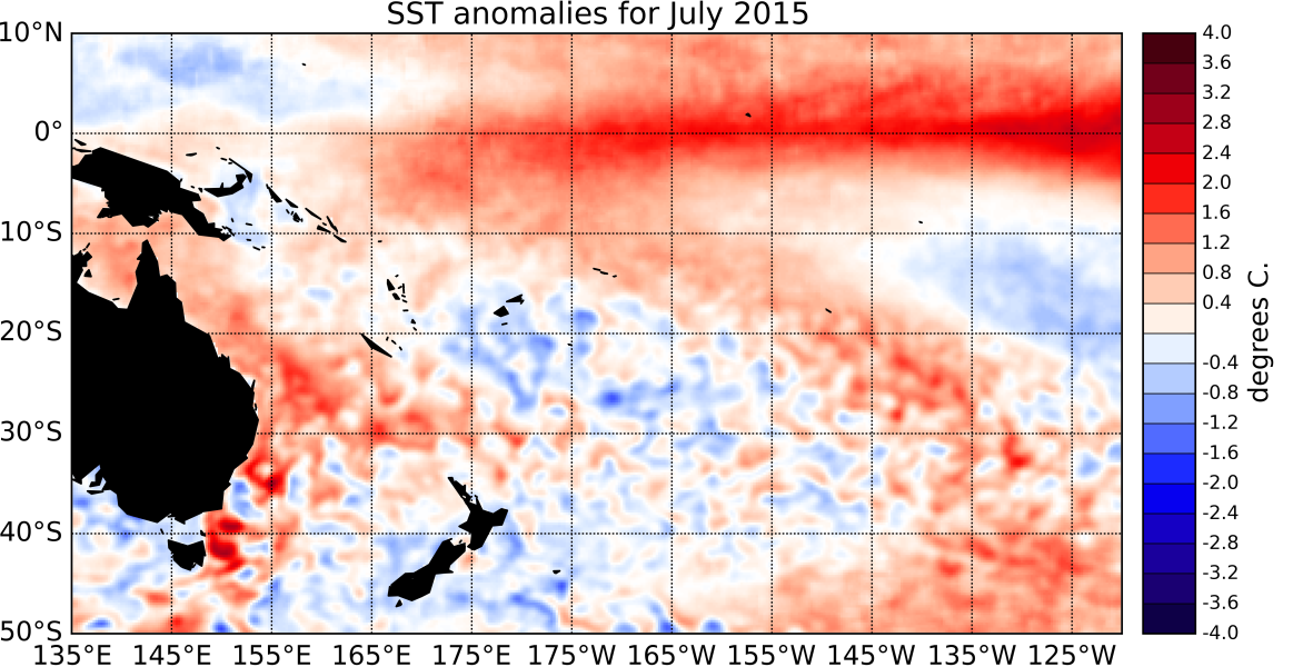
Sea Surface Temperatures (SSTs) have continued to increase in the central and eastern Pacific. The Southern Oscillation Index (SOI) has also remained strongly negative and is at -1.5 for July 2015 as a whole. Consistent with patterns typically seen during El Niño, convection and rainfall were suppressed in the western Pacific and over the Maritime Continent (west of the International Dateline), while the Intertropical Convergence Zone (ITCZ) was much more intense than normal in the eastern Pacific.
The South Pacific Convergence Zone (SPCZ) adopted a more zonal position in the western Pacific. The ENSO Precipitation Index (ESPI) reflects strong El Niño conditions with a value of +2.64 (value to the 5th of August). SST anomalies this moth are again above the 1°C mark in all of the NINO regions: The NINO3.4 index value is +1.48°C, NINO4 (in the west-central Pacific) is currently at +1.1°C and the NINO3 index (in the eastern Pacific) continued to increase during July 2015, and now reaches +1.89°C above normal.
Sub-surface ocean temperature anomalies in the eastern Pacific persisted (exceeding +5C between 50 and 100m depth), while cooler than normal ocean subsurface temperatures that were present in the western Pacific intensified between 100 and 200m. Positive upper ocean heat content anomalies (upper 300m of the Ocean) still exceed +2oC in the central and eastern Pacific.
The Madden-Julian Oscillation (MJO) was associated with suppressed intra-seasonal convective activity in the western Pacific during the past two weeks. At the forecast horizon of 14 days, both the dynamical and statistical CPC forecasts indicate slightly reduced intra-seasonal convective activity over the Maritime Continent and the far western Pacific. International guidance indicates that El Niño is virtually certain (97% probability) to continue over the next three months (August – October 2015) and extremely likely (> 90% probability) to persist into the summer 2015/2016.

