Background
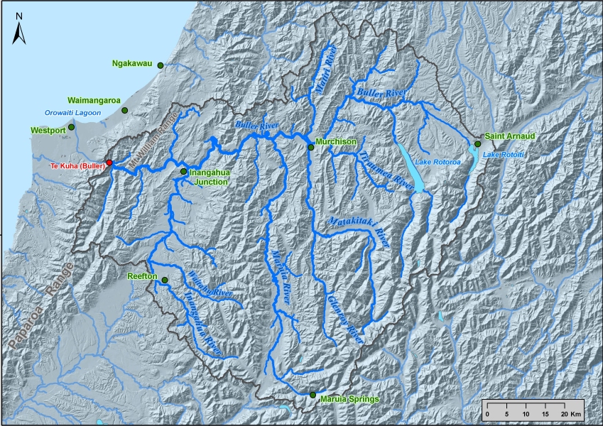
The Buller River catchment (see map on right) has a catchment area of 6350 km2 and a mean flow of 454 m3/s at Te Kuha a few kilometres upstream of the Buller flood plain where Westport is located. The sources of the Buller River are Lakes Rotoiti and Rotorua and rivers draining the Southern Alps. However, the main source of floods are the tributaries immediately upstream of Te Kuha that drain the rugged Paparoa and McWilliams Ranges as they intercept moisture-laden winds crossing the Tasman Sea.. The Buller River at Te Kuha has the largest estimated flood peak in New Zealand of 12,700 m3/s in 1926 (Soil Conservation and Rivers Control Council, 1957). Westport is particularly vulnerable to flooding because it is on the flood plain between the Buller River and the Orowaiti Estuary, an old channel of the Buller River that carries a substantial flow during large floods.
One of the principal reasons the Buller River catchment was chosen as a case study for this project was because there was already a calibrated 2-dimensional hydrodynamic model for this area from previous commercial and government (FRST) funded work.
The initial work for the Buller/Westport was commissioned in 2003 by the Buller District Council to quantify the extent of Westport's flood hazard. Westport is vulnerable to inundation from both river floods and high sea levels. The Buller model was also used in work commissioned by MfE in 2005 to examine the effects of simulated climate change. The model was revised in 2009 after a Lidar survey facilitated the compilation of a more accurate digital elevation model (DEM). The new DEM was used to model the flood extents for 1% and 2% AEP floods. It was this model that was used as an example for the Toolbox.
The case study
This case study demonstrates a method for adjusting historic daily rainfall data associated with a past (approximately 1-in-50 year) flood event according to projected future changes to mean rainfall. The adjusted rainfall data are used in combination with projections of sea level rise to re-model the historic flood flow in the Buller River, and to produce maps of potential flood inundation using a sophisticated hydraulic model. RiskScape was then used to assess damage estimates to buildings associated with the projected inundation levels.
A simplified hydraulic flood model of the Buller River was also produced and calibrated using outputs from the detailed model. The simplified model was used to generate multiple flood risk maps for a range of different flooding scenarios both for present day and future conditions. Various high-level alternative strategies for adapting or mitigating against flood risk were then selected, with the aid of the Screening of Adaptation Options Tool 4.2, and further flood modelling undertaken to gain an understanding how these strategies may modify the flood risk.
Flood risk was determined using the subjective rating scheme embodied within the Subjective Quantified Risk Analysis Tool 3.5, which is designed to give order of magnitude risk-adjusted costs and benefits. These order of magnitude costs and benefits were combined with estimates of implementing the different strategies. The overall balance of benefits over costs for each strategy were then evaluated and compared using the Rapid Cost Benefit Analysis Tool 4.3.
Westport Case Study: Initial Assessment of Climate Change Flood Adaptation Options (PDF 998 KB)
The following table lists the tools associated with this case study and the location (Figures / Tables) of some of the key findings.
Tools associated with the Buller River flooding case study
| Tool Name | Tool Reference | Key Figure / Table |
|---|---|---|
| Sensitivity Matrix Tool for Assessing Vulnerability of Urban Environments to Climate Change | [Tool 1.6] | Appendix: Westport sensitivity matrix. Flooding was identified as a significant vulnerability. |
| Modelling future heavy rainfall | [Tool 2.1.2] |
Table 3.5: Projected changes to the peak 24-hour (9am-9am) rainfall in the Buller catchment for each future scenario, and the resulting changes to catchment runoff modeled by TopNet. Peak rainfall is projected to increase by between 3.4 and 10.6% (depending upon the emission scenario and future period) with corresponding increases in runoff of between 3.4 and 13.1%. |
| Hydrological modelling present-day and future floods | [Tool 2.1.3] |
Table 3.1: Projected changes to the peak flood flow in the Buller catchment for each future scenario. The peak flood flow is projected to increase by between 300 to 1000 m3/s (depending upon the emission scenario and future period) from the base historical flood case of 8500 m3/s. This represents an increase in the flood ARI from 47 years to between 66 to 113 years (based on the current climate). |
| Inundation modelling of present-day and future floods | [Tool 2.1.4] |
Table 3.1: Shows the modelled climate scenarios, periods, peak flows, the annual exceedance probability (AEP) of the river flood peaks in terms of the current climate, tide levels and the extent of inundation of Westport town. The percent area of Westport inundated with water depths > 0.2 m increases from 51% for the historical base case to 70% under the mid-range (A1B) emissions scenario for 2090. The average inundation depth above ground increases from 0.49 m to 0.76 m. |
| Case study example of risk assessment using RiskScape | [Tool 3.3] |
Figures 4.9–4.11 and Table 4.1: Example output from Riskscape for the 2090 mid-range emission (A1B) flooding case. The increase in the percent of Westport buildings flooded (from the base flood case to the 2090 mid-range emissions case) is +12%, with replacement costs to flooded building contents (in 2010 dollars) increasing by $64 million. |
|
Westport Case Study: Initial Assessment of Climate Change Flood Adaptation Options
| The study illustrates the use of selected Toolbox tools in a real situation to provide insight to decision-makers and affected communities on the relative merits of broad options for flood mitigation in response to climate change. The study seeks to show how fundamentally different flood adaptation options for Westport can be compared and their economic viability evaluated at a strategic level and in a robust way to help inform future policy directions and flood mitigation planning. |
Related links
- Other Urban Impacts Toolbox case studies
- Climate variability and change
- NZ temperature record
- Climate change scenarios for New Zealand


