What is streamflow depletion?
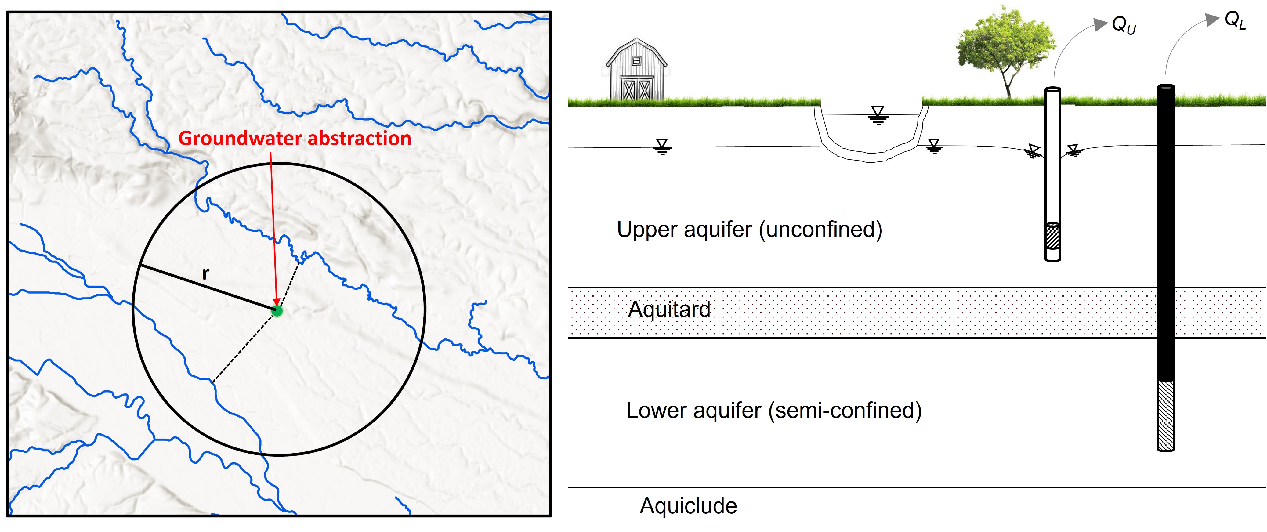
In many catchments, surface and groundwater are closely coupled. Abstraction of water from groundwater (aquifers) and surface water bodies (rivers and streams) reduces natural streamflow, which is defined as streamflow depletion. The depletion due to the surface water abstractions can be easily measured as they instantaneously deplete the stream. However, the impact of groundwater abstractions on streamflow is complex; abstraction of groundwater reduces the discharge of groundwater into streams, and increases loss of water from the stream to the aquifer (recharge). These changes occur as hydraulic gradients between aquifer and stream are reduced – both these phenomenon cause streamflow depletion.
Why is it important to understand streamflow depletion?
Intensifying competition for water is increasing pressure on finite water resources (surface and groundwater), which manifests itself as depleted stream flows. As the concerns over water resources and the environment increase, the importance of combined water management, which acknowledges the integrated nature of groundwater and surface water, and manages them as a single resource, is critical to sustain both human society and aquatic and terrestrial ecosystems.
Why is streamflow depletion modelling important in water resources management?
It is difficult to directly measure streamflow depletion due to complex groundwater flow systems and long response times following the abstractions (weeks, months or even years). While numerical surface-groundwater models (e.g. MODFLOW) can overcome the above limitations, it is generally cost and data prohibitive to develop such models at regional scale, and site-specific models cannot be used at other spatial locations. However, it is important to have nationally consistent methods for national studies and reporting (e.g., environmental reporting).
Method – NIWA’s streamflow depletion model
Our model simulates streamflow depletion due to both surface and groundwater abstractions. The rate of stream depletion due to abstracting groundwater may depend on many factors (e.g., pumping rate, distance, depth, aquifer hydraulic properties). The extent and reliability of data and information available for estimating streamflow depletion vary considerably within and between regions. Therefore, we developed two different approaches to estimate streamflow depletion – the choice of approach is determined by the information available regarding local groundwater conditions:
- A one-layer model - The aquifer from which groundwater is abstracted is essentially a single unconfined aquifer and the well is hydraulically connected to nearby streams.
- A two-layer model - A two-model approach is used based on the screen depth of the groundwater well. The approach described in the above (1) is used for the groundwater abstraction (screen depths) within 0-30 m below ground level. Streamflow depletion due to pumping from the bottom aquifer is estimated assuming that water is pumped from a semi-confined aquifer partially confined by soil layers of low permeability).
Two aquifer parameters (transmissivity and storativity) are used for calculating the streamflow depletion. Field tests can be used to measure aquifer parameters. For areas where observations are unavailable, we used Random Forest statistical techniques to estimate the parameters.
Our model can be used to estimate streamflow depletion at any reach of the stream network, and cumulative catchment streamflow depletion.
How does the streamflow depletion model work?
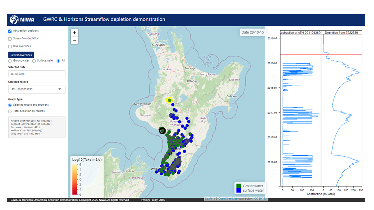
- An online interactive app provides access to the tool.
- The user can view groundwater and/or surface water points.
- The user selects a particular point in a stream.
- The model determines the distance from that point to nearby water extraction source(s).
- The model provides a time-series estimate of the cumulative streamflow depletion (the rightmost panel in Figure 3) resulting from all the observations at and above the river reach in graphical form, along with other information.
- Models can be developed for a region or catchment.
What questions does this model address?
- How much water is extracted from a particular stream/aquifer or catchment?
- How will water abstraction impact on streamflow?
- What would happen if we turned off water abstraction?
- How much more water could be allocated sustainably?
Who can use this model?
This tool can be used by regional and district councils, central government agencies, water managers, catchment groups, hydro-electric generators, researchers and consultants.
Previous applications of the model:
The model has been set up at regional scale (e.g. Greater Wellington, Horizon and Canterbury) and catchment scale (e.g. Hauraki in Waikato). If you are interested in trialing the model, please contact our research team for more information.
Download:
New Zealand streamflow depletion model: A tool for sustainable water resource management (PDF 1.32 MB)