Models have an important role to play in water management in New Zealand.
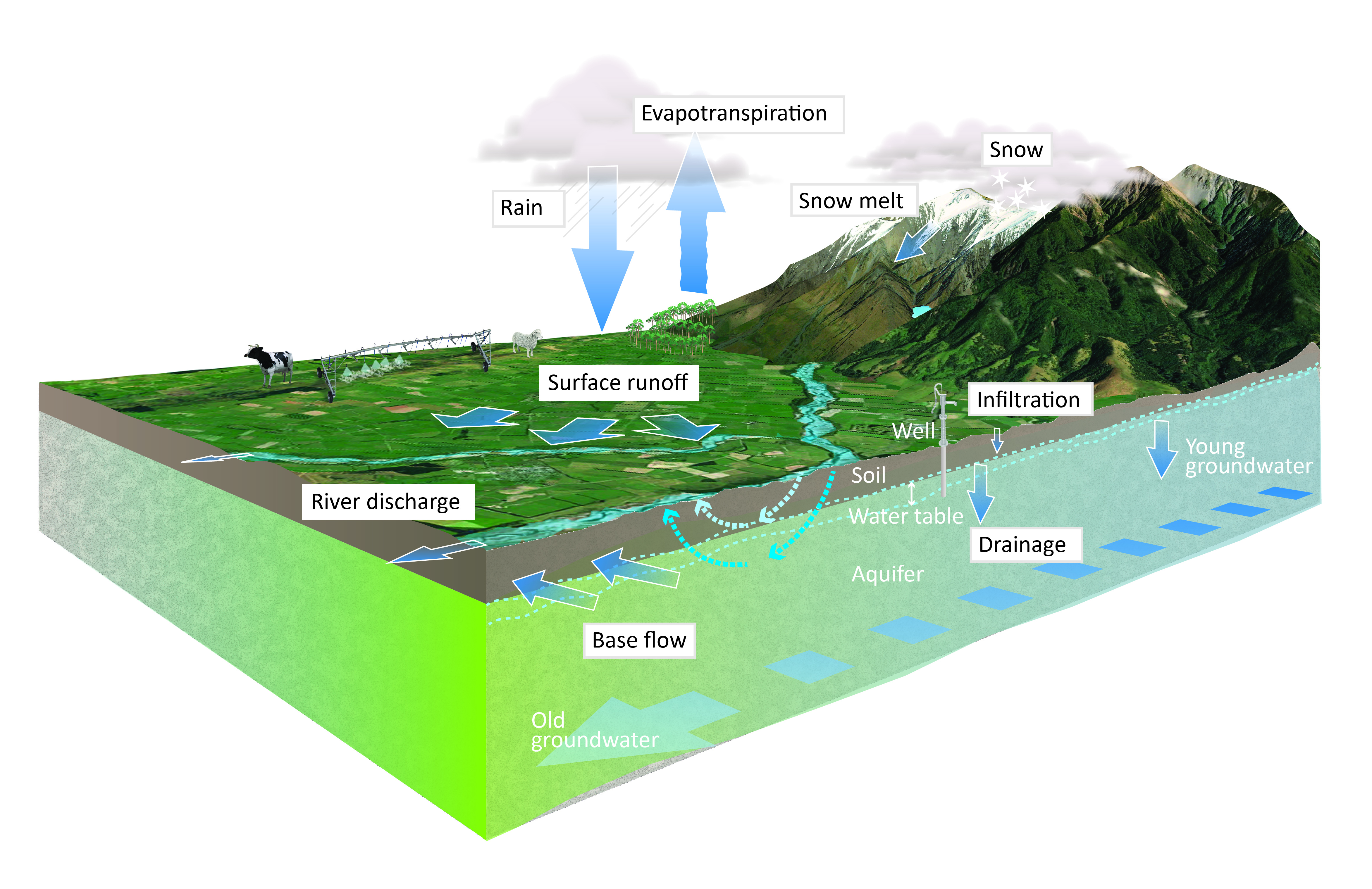
To be useful, models need to be both flexible and complex; flexible because they are needed for a wide range of purposes, and complex because they need to simulate complex natural and man-made systems (Figure 1). Ideally, these models will have a modular design, so that sub-models that represent hydrological, climatic, water quality, ecological and other processes can be added.
NIWA is leading the development of the New Zealand Water Model (NZWaM). NZWaM is an integrated platform that will link a wide range of environmental data into a modular modeling system. The physical domain of NZWaM extends from the top of the atmosphere to rivers, lakes, aquifers and estuaries (Figure 1).
NZ Water Model - Hydrology
The New Zealand Water Model – Hydrology (NZWaM-Hydro) will be the first component of the NZWaM platform completed. NZWaM-Hydro is being developed via a partnership between NIWA, GNS Science, Manaaki Whenua - Landcare Research, Ministry for the Environment, Ministry for Primary Industries, Environment Southland, Horizons Regional Council and Gisborne District Council.
NZWaM-Hydro will provide essential hydrological information for land and water management and planning at national, regional, catchment, and sub-catchment scales in New Zealand. NZWaM-Hydro is scalable and the hydrological relationships in the model are transferable between locations, which make it suitable for many different applications. Potential applications include national and regional policy development, water allocation and flow setting, water accounting, and flow, flood and drought forecasting (particularly in ungauged catchments). The modular design of NZWaM-Hydro will allow coupling to sub-models that predict water quality (NZWaM-Water Quality) and ecological conditions (NZWaM-Ecology) as these are developed from other research NIWA is undertaking.
(Visit NZWaM- Hydro Use and Applications for the full list of potential uses of the model)
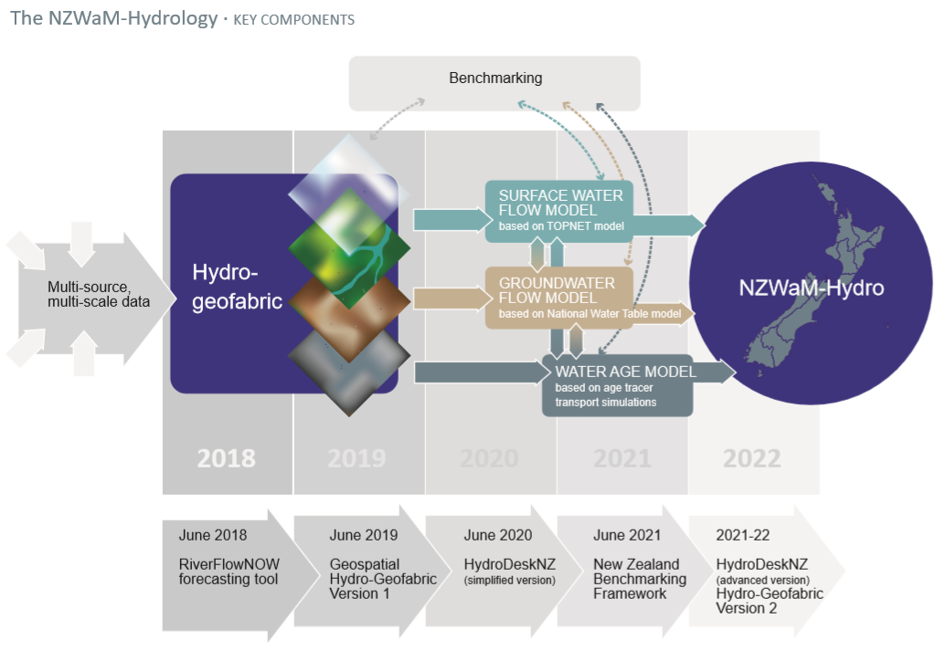
Key components
Figure 2 illustrates the key components of NZWaM-Hydro. At the core of NZWaM-Hydro is an integrated and dynamic geospatial database, the hydro-geofabric. The hydro-geofabric will store harmonised, standardised and up-to-date geospatial information. This information includes spatial and temporal data from direct observations (e.g., soils, geology, land use, climate), and derived parameters (e.g., soil moisture content at saturation, hydraulic conductivity in different hydro-geological layers). It will also include an updated digital river network with finer spatial resolution than the previous version, and surface and groundwater isotope data that is being collected by NIWA in collaboration with regional and unitary councils.
The surface water flow model of NZWaM-Hydro is based on NIWA’s TopNet rainfall-runoff model, which is widely used for environmental flow setting and for evaluating water resource availability. This surface water flow model will represent evaporation, soil-moisture and groundwater recharge processes using the latest soil, landcover and climate data. It will be tested across a range of catchment types and conditions to maximise its applicability to all regions of the country.
The groundwater flow model is based on the GNS Equilibrium Water Table model. Its role is to predict aquifer hydraulic properties and groundwater fluxes. To develop this model, we bring together data in the hydro-geofabric, our understanding of losing and gaining stream reaches, and water-table fluctuations from the GNS model.
The water-age model is being developed with current and new surface and ground water isotope datasets. The isotope data will be used to identify water from different origins (e.g., rainfall, shallow and deep groundwater), which will allow identification of flow pathways within and between river networks and aquifers.
The surface water and groundwater models are coupled to represent water exchange between land, surfacewater bodies and aquifers, and the water age model specifies the location and rate of water exchange (Figure 2). The three coupled models run on supercomputers at NIWA’s High Performance Computing facility.
Model benchmarking will involve the development and implementation of state-of-the-art operational methods to test the three models described above with respect to observed surface and groundwater data. Guidance on the potential uses and limitations associated with the models will be produced.
River flow forecasting
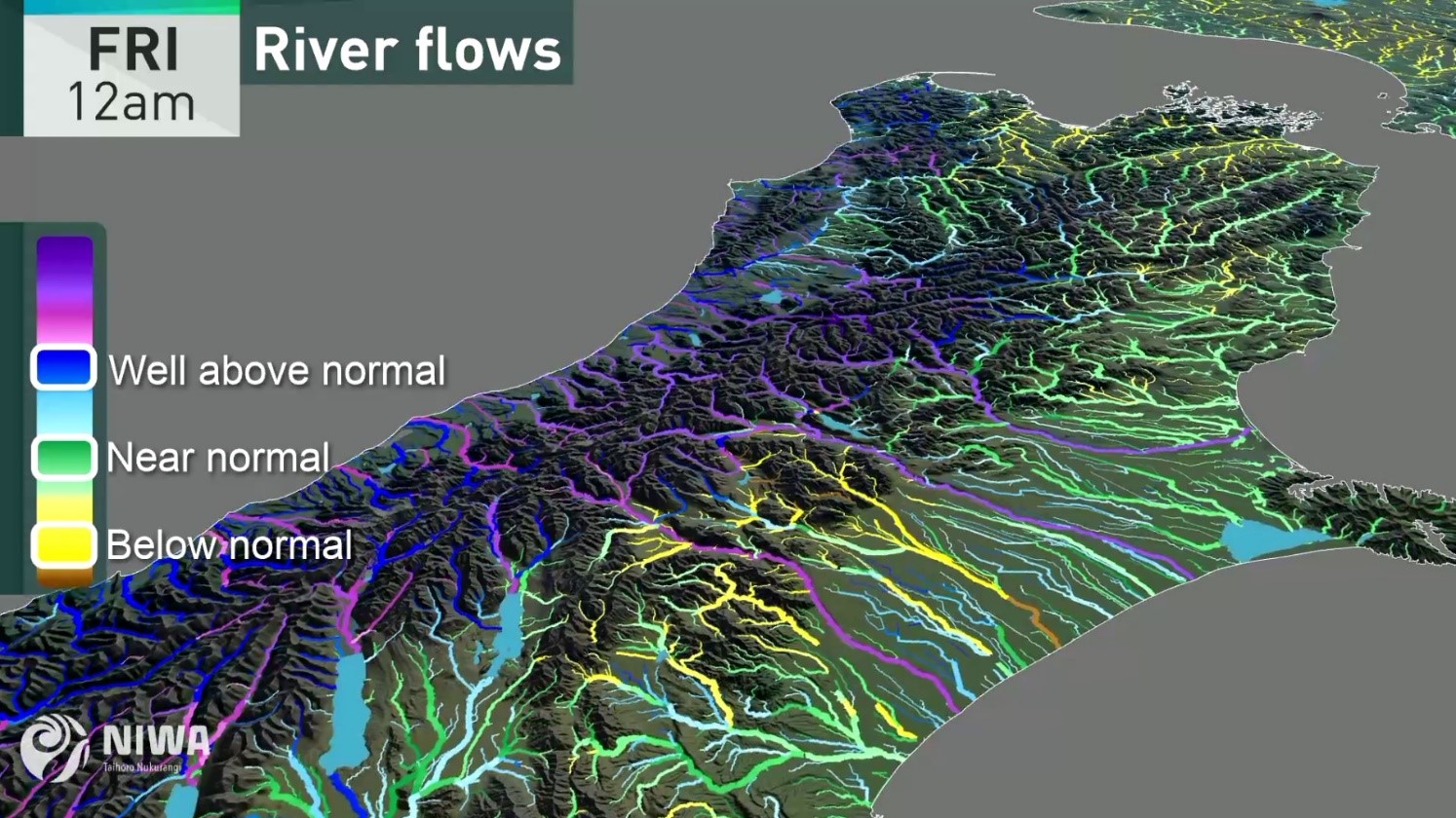
In addition to NZWaM-Hydro, NIWA is developing an operational river flow forecasting system. This system will provide hourly forecasts, two days in advance, for more than 60,000 rivers across New Zealand. The forecasts will delivered and displayed as flow categories, as shown in Figure 3. The categories are based on long-term flow simulations, which were generated from 40 years of climate records from hundreds of sites in NIWA’s Virtual Climate Station Network. The forecasting operation uses NIWA’s High Performance Computing facility to link the TopNet model with high-resolution weather model output and satellite and climate station data (Figure 3). A working group of stakeholders has been established to assess the river forecast information and direct ongoing model development and innovation strategies.
Future plans
In 2019, data from the hydro-geofabric will be used for a conceptualisation of groundwater systems, which will improve our predictions of variation in groundwater levels in space and time. A user-interface, ‘NZWaMHydroDesk’, will be released by 2020, and will allow a wide range of users to access data and model simulations held within the hydro-geofabric. All components of NZWaM-Hydro are scheduled for completion by 2022, with a period of data quality assurance and benchmarking, and improvements to both the user interface and hydro-geofabric.
As NZWaM-Hydro nears completion, new sub-models will be added to the NZWaM platform to extend its capabilities beyond hydrological predictions. The range of potential sub-models is very broad; the only constraint is that sub-models can be driven by output from NZWaM-Hydro (e.g., time-series of river-flows and groundwater levels). Sub-models under consideration include hydraulic habitat models for river biota to inform environmental flow-setting, models for predicting contaminant loads to water bodies under different land-use and climate scenarios, erosion and sediment transport models, and models that predict the extent and severity of land-slides, coastal inundation and other natural hazards.