Background
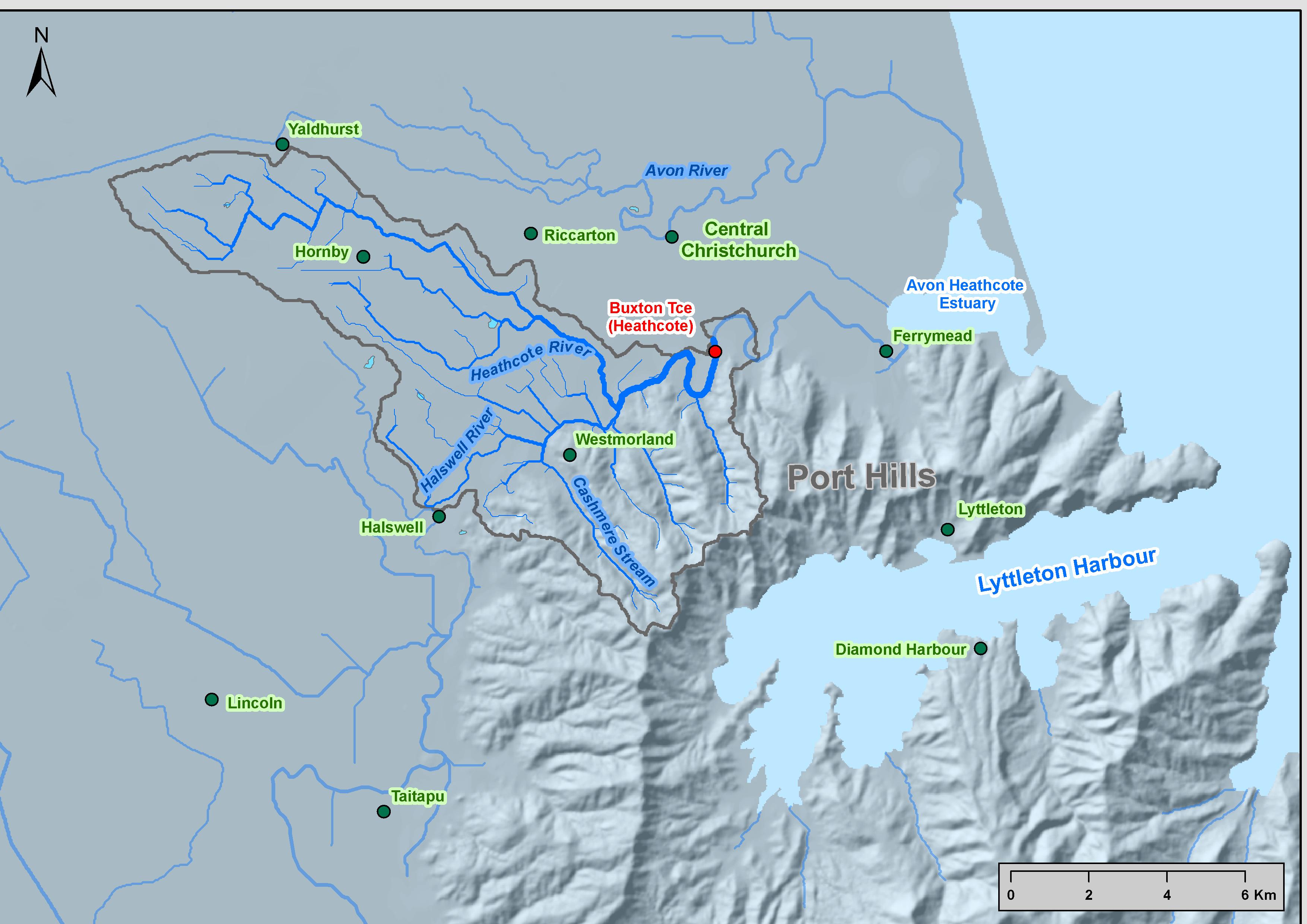
The Heathcote River has a relatively small catchment area of ~103 km2 at the Ferrymead Bridge where the river discharges into the Avon-Heathcote Estuary (see map on right). The river is small (mean flow at Buxton Terrace of 1.28 m3/s) in its non tidal reaches, but it has a well sustained base flow which is fed from groundwater originating from rainfall on the plains portion of the catchment and recharge from the Waimakariri River. Much of the flood flow originates from the Port Hills, but during extreme events that overwhelm the capacity of the Henderson Basin flood detention area the plains portion of the catchment can add substantially to flood flows.
The Heathcote River was initially chosen for this study because it flowed through a low lying urban area that was vulnerable to flooding that is of concern to the Christchurch City Council. As the study area is urban it allowed the application of fragility algorithms to estimate flood damage. The Heathcote River is also tidal within the urban area which makes part of the catchment vulnerable to sea-level change and so it is suitable for a climate change study that also includes the effects of sea-level rise.
The Christchurch earthquake of 22 February has lifted the tidal portion of the Heathcote catchment by about 0.4 m and lowered the rest by 0.1-0.3 m. Thus, the reported inundation modelling (performed using pre-earthquake topographic and bathymetric data) should be interpreted with this in mind. Nevertheless, the methods used are quite applicable.
The case study
For this case study the effect of climate change on rainfall was estimated using the design event approach [see Tool 2.1.2], where extreme rainfall amounts are increased by a percentage per degree of warming. The rainfall depth was based on rainfall statistics provided by Griffiths et al. (2009) and the temporal pattern of rainfall was taken from an observed severe rainfall event. The simple screening approach outlined in MfE (2010) was used to calculate the effect of various climate scenarios on the design event.
Following this, a hydrological rainfall-runoff model (a TopNet model of the Heathcote calibrated to 8 flood events) was used to convert these changes in rainfall to changes in river flow [see Tool 2.1.3]. Each design rainfall was used as input to the rainfall-runoff model, to produce a different flood hydrograph for each climate change scenario.
A hydraulic model was employed to assess impacts on flood inundation [see Tool 2.1.4]. Each flood hydrograph was used as input into the hydraulic model. Lastly, the flood inundation data were used as input into Riskscape to estimate the likely costs of future flooding in the Avon-Heathcote area.
The following table lists the tools associated with this case study and the location (Figures / Tables) of some of the key findings.
Tools associated with the Heathcote River flooding case study
| Tool Name | Tool Reference | Key Figure / Table |
|---|---|---|
| Sensitivity Matrix Tool for Assessing Vulnerability of Urban Environments to Climate Change | [Tool 1.6] | Appendix: Christchurch sensitivity matrix. Flooding was identified as a significant vulnerability. |
| Modelling future heavy rainfall | [Tool 2.1.2] |
Table 3.4: Projected changes to daily rainfall totals for Christchurch Gardens for several return periods and future scenarios. The 100-yr return period daily rainfall is projected to increase from 138 mm (present-day) to as much as 193 mm (2090, A2 emission scenario). |
| Hydrological modelling present-day and future floods | [Tool 2.1.3] |
Figure 3.2: Projected changes to the 100-yr ARI flood flow in the Heathcote River at Buxton Terrace for each future scenario. The peak flood flow is projected to increase from around 65 m3/s (current climate) to between approximately 80 to 130 m3/s (depending upon the emission scenario and future period). |
| Inundation modelling of present-day and future floods | [Tool 2.1.4] |
Table 3.2: Shows the modelled climate scenarios, periods, peak flows, the annual exceedance probability (AEP) of the river flood peaks in terms of the current climate, tide levels and the inundated area (in square kilometres). The inundated area increases by between 56 and 467%, depending upon the emission scenario and future period. |
An impacts analysis using Riskscape (not reported in any of the Tools; using pre-earthquakes elevation data) showed that based on the projected changes to the Heathcote River flood peak and the resultant likely increases to inundated area (taking into account sea level rise) as described in the Tools in the above table, the estimated increase in replacement costs (2010 dollars) to flooded building contents is between NZ$114M (2090 mid-range scenario) and NZ$315M (2090 high range scenario).
Related links
- Other Urban Impacts Toolbox case studies
- Climate variability and change
- NZ temperature record
- Climate change scenarios for New Zealand