A weekly update describing soil moisture patterns across the country to show where dry to extremely dry conditions are occurring or imminent. Regions experiencing significant soil moisture deficits are deemed “hotspots”. Persistent hotspot regions have the potential to develop into drought.
Recent rainfall and current soil moisture conditions:
North Island:
- Rainfall totals of 30-70 mm were generally observed across Bay of Plenty, the Coromandel Peninsula, and parts of northern Hawke’s Bay in the past week.
- The rest of the upper half of the North Island generally received 15-25 mm, while the lower North Island generally received less than 15 mm.
- Soil moisture decreases were observed across many regions in the past week.
- The driest soils across the North Island, when compared to normal for this time of the year, are found near Cape Reinga and along the east coast from Hawke’s Bay to Wairarapa, while the wettest soils for this time of the year are found in western Waikato.
- Hotspots remain in place around Napier and Hastings in Hawke’s Bay.
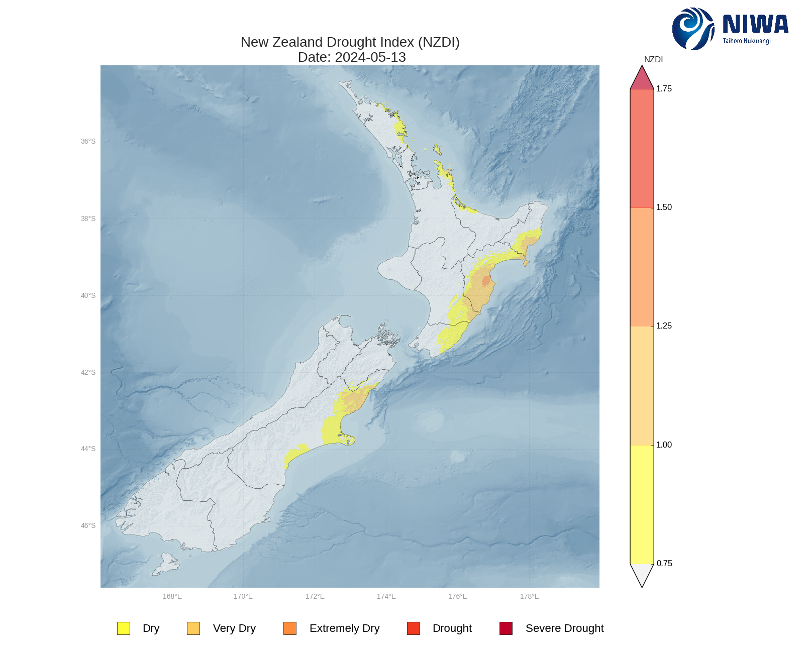
- As of 13 May, the New Zealand Drought Index (NZDI) map below shows that abnormally dry conditions are currently found in eastern Northland, the Coromandel Peninsula, and much of the east coast from Gisborne to Wairarapa. Very dry to extremely dry conditions are located in the eastern North Island as well.
South Island:
- Meagre rainfall occurred across nearly all of the South Island in the past week, with most locations receiving 5 mm or less, and some locations receiving no rainfall at all.
- However, rainfall totals were a bit higher in Tasman and Fiordland, where 15-30 mm was generally observed.
- This resulted in moderate soil moisture decreases across much of the South Island.
- The driest soils across the South Island, when compared to normal for this time of the year, are found from Nelson to northern Canterbury, while the wettest soils for this time of the year are found in Southland.
- Hotspots remain in place in central Canterbury and isolated parts of southern Canterbury.
- As of 13 May, the New Zealand Drought Index (NZDI) map below shows that abnormally dry conditions are currently found in northern and central Canterbury, and very dry conditions are located in northern Canterbury as well.
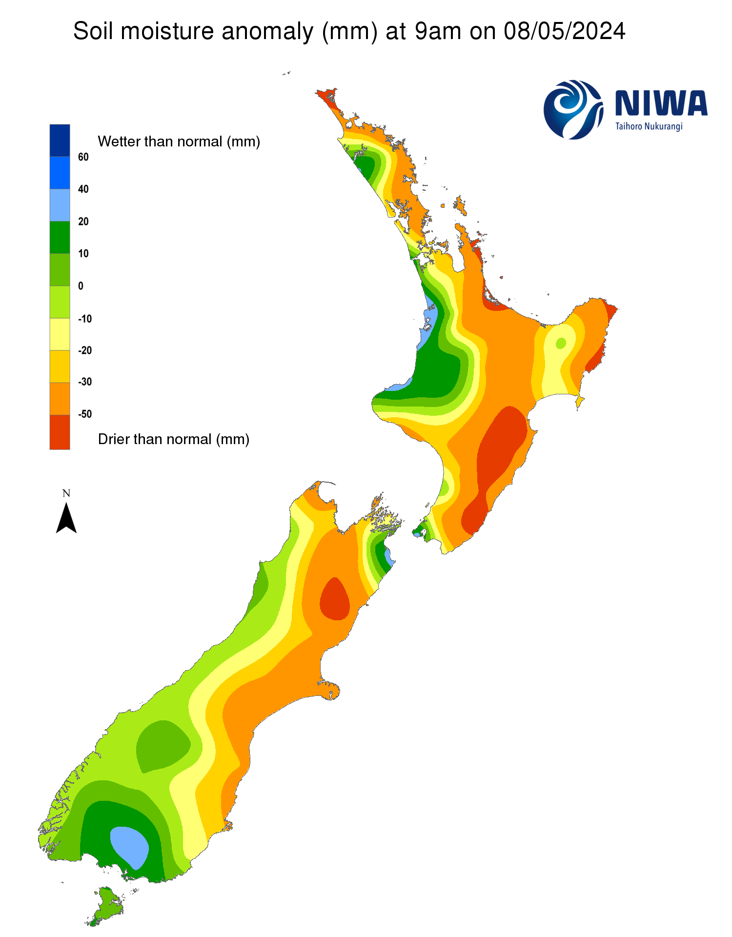
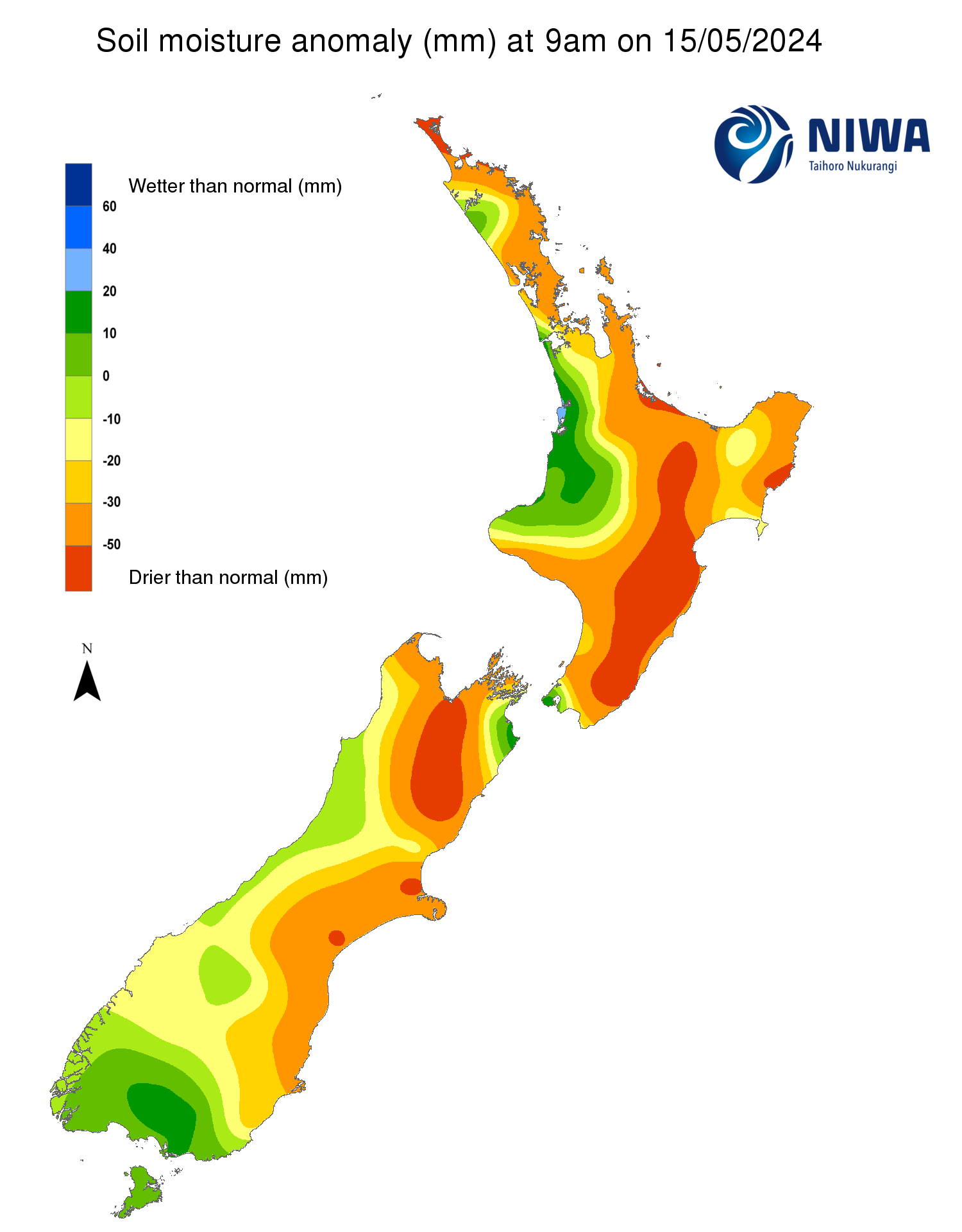
Pictured above: Soil Moisture Anomaly Maps, relative to this time of year. The maps show soil moisture anomalies over the past two weeks.
As of 13 May, the New Zealand Drought Index (NZDI) map below shows that abnormally dry conditions are currently found in eastern Northland, the Coromandel Peninsula, much of the east coast from Gisborne to Wairarapa, and northern and central Canterbury. Very dry to extremely dry conditions are located in the eastern North Island and northern Canterbury. Please note: some hotspots in the text above may not correspond with the NZDI map. This difference exists because the NZDI uses additional dryness indices, including one which integrates the rainfall deficit over the past 60 days. Changes are therefore slower to appear in the NZDI compared to soil moisture anomaly maps that are instantaneously updated.
The week ahead:
North Island:
- High pressure will bring generally dry weather to the North Island from Friday to Monday (17-20 May).
- However, from Tuesday (21 May), low pressure may bring rain primarily to the upper North Island, while the lower North Island stays mostly dry.
- Weekly rainfall totals may reach 20-40 mm in the upper North Island, while lighter amounts of 15 mm or less are favoured in the lower half of the North Island.
- Due to the expected rainfall in the next week, additional soil moisture decreases will be likely across the lower North Island, while the upper North Island may see at least small increases.
- The current hotspots located in Hawke’s Bay will likely not change significantly in the next week.
South Island:
- A front will bring areas of moderate to heavy rain to the lower and central West Coast from late Friday through Sunday (17-19 May), but other regions will receive little if any rainfall during this time.
- From about Monday (20 May), several days of mostly dry weather are expected as high pressure moves into the region.
- Weekly rainfall totals of 50-100 mm will be possible in the lower and central West Coast and Fiordland, with up to 25 mm in Southland.
- However, the rest of the island may receive 10 mm or less, with some locations potentially receiving no rainfall at all in the next week.
- Due to the expected rainfall in the next week, additional soil moisture decreases will be likely in the upper and eastern South Island, with little change expected for the West Coast.
- The current hotspots located in Canterbury may strengthen at least slightly in the next week.
Long-term outlook (through mid-June):
- The drier (25th percentile) and middle (50th percentile) rainfall scenarios both show below normal to well below normal rainfall widespread across nearly the entire country.
- Even in the wetter (75th percentile) scenario, below normal rainfall is signalled across significant portions of both islands, increasing confidence in a below normal rainfall outcome in the coming weeks.
- Very dry soil conditions may affect parts of eastern New Zealand, particularly in the drier scenario.
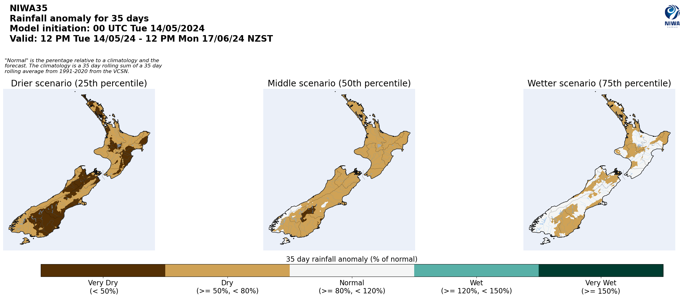

Pictured above: 35-day forecast rainfall anomaly scenarios (Top), and 35-day forecast dryness and drought scenarios (Bottom). These maps are updated daily at https://niwa.co.nz/climate/seasonal-climate-outlook
Background:
Hotspot Watch: a weekly advisory service for New Zealand media. It provides soil moisture and precipitation measurements around the country to help assess whether extremely dry conditions are imminent.
Soil moisture deficit: the amount of water needed to bring the soil moisture content back to field capacity, which is the maximum amount of water the soil can hold.
Soil moisture anomaly: the difference between the historical normal soil moisture deficit (or surplus) for a given time of year and actual soil moisture deficits.
Definitions: “Extremely” and “severely” dry soils are based on a combination of the current soil moisture status and the difference from normal soil moisture (see soil moisture maps at https://www.niwa.co.nz/climate/nz-drought-monitor/droughtindicatormaps)
Hotspot: A hotspot is declared if soils are "severely drier than normal" which occurs when Soil Moisture Deficit (SMD) is less than -110 mm AND the Soil Moisture Anomaly is less than -20 mm.
Please note: This is the final Hotspot Watch for this season. The Hotspot Watch will return in the spring. In the meantime, you can keep up-to-date on longer term forecasts and outlooks at https://niwa.co.nz/weather-forecasting/seasonal-climate-outlook . Here you will find our three month, or seasonal climate, outlook as well as our daily updated 35 day rain and dryness forecast.
