PDF of this article (1.95 MB)


Over the centuries, Māori have recorded a litany of natural hazards and catastrophic events in their stories, songs, and place names. Now Darren King, James Goff, and Apanui Skipper are investigating how this wealth of information can complement scientific studies and management of natural hazards.
In New Zealand, we’re exposed to a range of natural hazards. Why should the relatively short record since European settlement be all that we know about these things? Obviously it isn’t: we have geology, geophysics, and other branches of Western science to look further back in time. But we also have Māori environmental knowledge (MEK), or Mātauranga taiao. It’s a cumulative body of knowledge that is part of a wider understanding of the natural and spiritual world, or Mātauranga Māori. This form of knowledge is regarded as both ‘traditional’ and contemporary, representing the experiences of generations of Māori in New Zealand.
We have reviewed a wide range of written records (which are based on oral recordings and traditions) to compile details of past natural hazards as remembered through a variety of forms: pakiwaitara (stories), mōteatea (laments), pepeha (quotations), whakataukī / whakatauākī (proverbs), and waiata (songs). They tell about catastrophic events, such as earthquakes and volcanic eruptions, and areas of high hazard risk, such as flood-prone rivers; and they forewarn hazardous environmental conditions, such as storms and drought. We discuss this research in greater detail in our article ‘Māori Environmental Knowledgeand natural hazards in Aotearoa–New Zealand’ (Journal of the Royal Society of New Zealand). For more about the use of environmental indicators, see ‘Understanding local weather and climate using Māori environmental knowledge’ (Water & Atmosphere).
Storms, floods, and taniwha in oral tradition
Many stories tell of the impacts from great waves caused by storms, inundation caused by incantations, and land or marine phenomena – known as taniwha – causing death, destruction, and peril for people living near water. It’s likely these stories were told to explain the causes of natural hazards, to record loss of life, and to serve as warnings about the nature of particular places.
In a story from the northern South Island, a taniwha living in a cave at Cape Campbell attacked people travelling along the coast between Cape Campbell and the Wairau River. (A similar story places a taniwha at Wairau River mouth.) The taniwha would approach the land with such force that the sea would rise up in front of it and sweep people off the land and into the lagoon behind. Eventually, it was killed by a great warrior who made the coast safe for subsequent travellers.
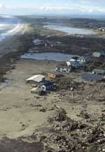
In another story, a group of Ngāti Tara from Taranaki were fishing off the coast of Wai-iti on the north Taranaki coast when they were caught in a large storm that drove them south to Rangitoto (D’Urville Island) in Tasman Bay. Eventually settling with their families at Moawhitu (Greville Harbour), they lived there until the community was wiped out by a wave. It is said the wave swept into the harbour, drowning almost everyone and “tumbling their bodies into the sand dunes”. According to the oral tradition, this disaster would have occurred around the 16th century. While there’s been no tsunami-related research at this site, early work in the area hints that there may be some geological evidence of such a tsunami-like event.
Environmental history in place names
We also looked at place names and their meanings, which can frequently provide clues about the local history, geography, biology, hydrology, and climate.Waikino, near Waihi, for instance, designates a point on a narrow river channel known to cause a dangerous torrent. In a similar manner, the name ‘Rangipo’, given to the barren tephra plain downwind of Ruapehu, Tongariro, and Ngaruahoe volcanoes, means ‘place of darkness’. While there are many examples like these, one must be careful when attributing significance to place names, as meaning can be confused through varying use of language and personal interpretations.
MEK and natural hazard management
Given the diversity of natural hazards faced by various Māori communities in the past and today, we can gain important insights from their experiences. MEK’s contribution to natural hazards science and management can include:
- raising community awareness about the hazard histories of local areas and the range of events that are possible
- providing important baseline information against which to compare environmental change
- helping to set research questions about local hazards and environmental processes,
- reconstructing time-lines of past hazards to help estimate the return periods of specific hazards events
- informing discussions about natural hazards preparedness, response, and recovery.
While there may be other valuable contributions that MEK can make to hazard management in New Zealand, it’s important to recognise that incorporating MEK into the process of hazard management does not end with documenting that knowledge. Rather, the process should actually involve Māori people, their knowledge, and expertise. By letting Māori share responsibility for hazard preparedness, response, and recovery, we can apply all the knowledge that Māori possess – not just traditional knowledge – to local hazards management and mitigation. Civil defence and local authorities tasked with hazards management should actively facilitate this knowledge sharing to ensure that MEK is incorporated into the decision making process; without it, New Zealanders are at greater risk than they need be.
Applying MEK to hazards
- Māori stories, songs, and place names record many generations of experience in New Zealand.
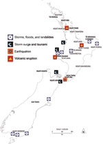
- Researchers have compiled and mapped those that carry information about natural hazards.
- Hazards managers can take advantage of Māori environmental knowledge by acknowledging these sources of local information and involving the Māori community in hazards planning.
He kupu whakamutunga
Ko aku kupu whakamutunga ko ēnei e whai ake nei, "Ka pūwaha te tai nei, hoea tahi tātou". Me hoe i te waka kia tika kia kore ai e tahuri. Nō reira e aku nui, e aku rahi, e aku toka tumoana tēnā hoki tātou katoa.
Further reading
Goff, J.R.; McFadgen, B.G. (2001). Catastrophic seismic-related events and their impact on prehistoric human occupation in coastal New Zealand. Antiquity 74: 155–162.
King, D.; Skipper, A. (2006). Understanding local weather and climate using Māori environmental knowledge. Water &Atmosphere 14(2): 22–23.
King, D.N.T.; Goff, J.; Skipper, A. (2007). Māori Environmental Knowledge and natural hazards in Aotearoa–New Zealand. Journal of the Royal Society of New Zealand 37(2): 59–73.
Smith, S.P. (1910). History and traditions of the Māoris of the west coast North Island of New Zealand prior to 1840. Memoirs of the Polynesian Society I: 175–185.
Turoa, T. (2000). Te Takoto o te whenua o Hauraki = Hauraki landmarks / Taimoana Tūroa; edited and additional material by Te Ahukaramū Charles Royal. Reed, Auckland. 280 p.
Darren King (Ngāti Raukawa) is based at NIWA in Auckland, where his work focuses on climate variability and change. Dr James Goff is a coastal scientist specialising in tsunami, working for NIWA in Christchurch. Apanui Skipper (Te Whānau-a-Apanui, Parehauraki) works with Te Kūwaha, NIWA’s Māori Research and Development Unit, from his base in Hamilton.
Teachers’ resource for NCEA Achievement Standards or Unit Standards: Education for Sustainability Level 2 AS90812 Science Level 2 US6352, Level 3 US21613, US6355
