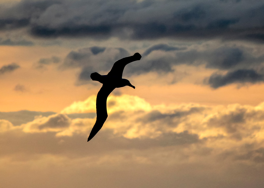
A Salvin’s albatross lifts slowly away from the barren Bounty Islands south-east of New Zealand.
It harvests the raw energy of the Southern Ocean winds on the start of its marathon journey towards the west coast of South America – more than 9,000km away.
As it sweeps in shallow arcs across the waves, a GPS tag taped to its back pings its location to a satellite above.
Moments later the Salvin’s position reaches NIWA marine ecologist Dr Dana Briscoe. Dana is more than 800km to the west in her Nelson office and she is modelling the bird’s prospects of survival.
The albatross doesn’t know it, but it is at the centre of a cutting-edge conservation programme that is matching state-of-the-art software with global wildlife tracking techniques.
Fatal attraction
Mapping the path of ocean wanderers like this Salvin’s albatross is no mean feat. But thanks to the efforts of researchers like Dana and her NIWA colleague Dr David Thompson, we’re learning more about the lives of these commanding creatures – where they fly, forage and feed.
It’s vital information because albatrosses are a study in contrasts. For all their strength, stamina and ability to fly thousands of kilometres over vast stretches of open ocean, these largest of seabirds are highly vulnerable to fatal encounters with commercial fishing vessels.
“…a good south wind sprung up behind, the Albatross did follow and every day for food or play, came to the mariner’s hollo!”
The Rime of the Ancient Mariner
So wrote Samuel Taylor Coleridge, almost 200 years ago. It’s the same old story today, and often with equally tragic results. Lured by the prospect of an easy meal, hundreds of birds are killed or maimed each year, accidentally hooked up on longlines or caught in incoming trawl nets.
Over the years, NIWA has tagged and tracked the year-round movements of many species of albatrosses, including white-capped, Buller’s, Salvin’s, northern and southern royals.
A new dataset, currently being assembled for the Department of Conservation (DOC), focuses on Salvin’s and Buller’s. The hope is that, over time, deeper insights can be gleaned into where they overlap in space and time with fishing fleets.
It’s valuable information that can be used to inform fisheries management and encourage seabird-safe fishing techniques, such as weighted longlines, that quickly pull hooks toward the seafloor, and coloured bird-scaring lines.
Tag and track
Helping save New Zealand’s 17 species of albatrosses from such deadly run-ins starts with knowing more about their sweeping sojourns. Enter tagging, tracking, GPS and geo-location.
Tagging albatrosses is surprisingly simple – it’s getting to them during the nesting season that’s the challenge. Many New Zealand albatrosses breed only on our rugged southern islands, exposed to the full fury of the Southern Ocean.
Buller’s albatross, for instance, nest exclusively on Solander Island in Foveaux Strait and the remote Snares. Campbell albatross reproduce on its namesake – an ancient volcanic island with steep coastal cliffs some 600km south of Stewart Island.
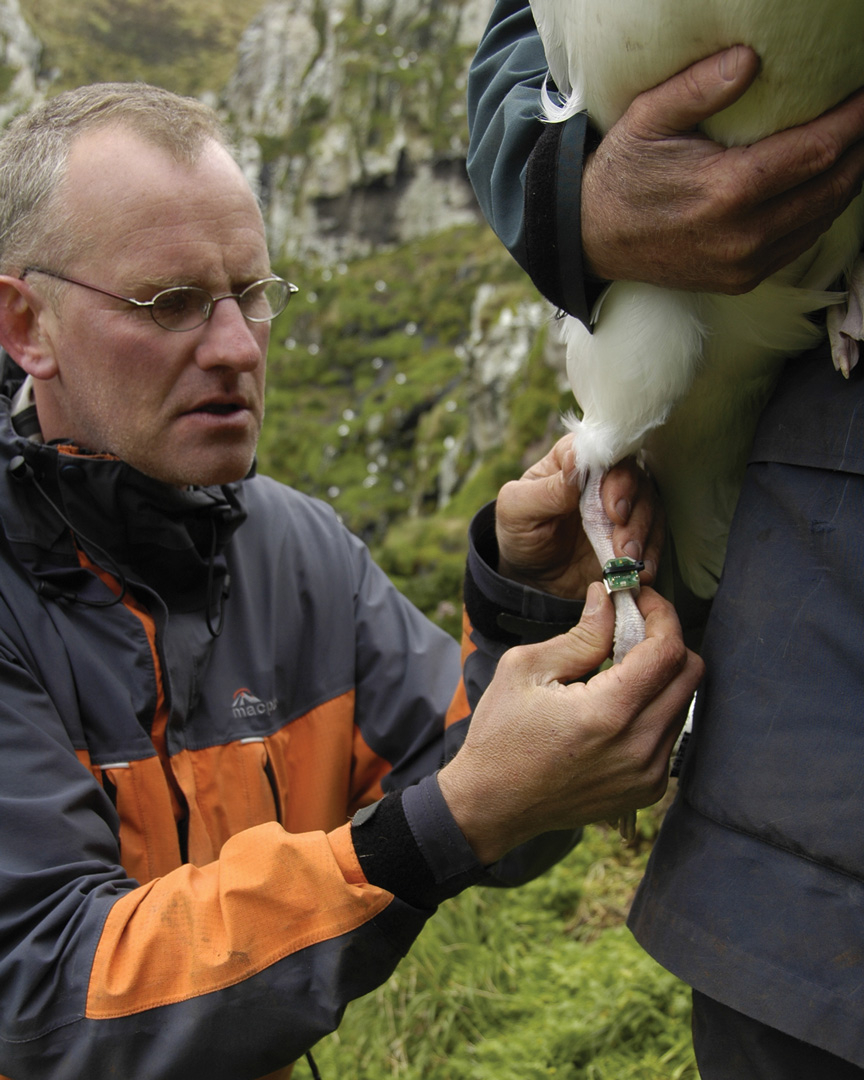
For Wellington-based seabird ecologist David Thompson, getting close to the birds for tagging often means long voyages in huge seas with his head near a sick bag. Once on land, however, the tagging process itself is comparatively easy because albatrosses nest just metres apart.
“We walk up to them when they’re incubating or looking after their small chicks and lift them off their nests. They resist but don’t run away. It’s a two-person job. One person lifts the bird, the other attaches the tag.”
On a recent trip to The Snares, David and fellow researchers took just two and a half hours to tag 50 Buller’s albatross.
Tag technology has developed in leaps and bounds since the late 1980s. Back then, tags were large and cumbersome. The new generation is smaller, faster and less power-hungry. That’s important because most albatross species migrate away from New Zealand – spending months travelling the globe. The units need to go the distance.
These days, NIWA’s tagging armoury consists of GPS and retrievable geo-location tags. Attached with waterproof tape to an albatross’s back feathers, GPS tags are expensive but can deliver real-time data every day, hour or minute. Transmitting the information via satellites, they enable researchers to track flight paths with pinpoint accuracy.
Geo-location tags aren’t as accurate and must be physically retrieved to access the data. But they are robust, can deliver large amounts of information and are considerably cheaper.
Attached with cable ties to a metal band on the bird’s leg, the tags feature a clock, light sensor, memory and battery. By recording light levels, they can register and record a bird’s latitude and longitude.
“These tags will last for years on a bird if you’re able to deploy them for that length of time and then retrieve the tag. They calculate two locations for the bird every day – one at midday; one at midnight.”
The number of albatrosses tagged and tracked by NIWA at any given time varies. Usually, there are about 50 birds fitted with geo-location tags and 20 with GPS tags.
Crunching the data
Back in Nelson, Dana Briscoe opens the software development package R and navigates hundreds of rows of tracking data. R is heavily used in the scientific community for computing and graphically representing statistical data. Clicking into a map plot, she can see where the GPS-tagged Salvin’s has been flying and gets an inkling of where it may be heading.

The idea behind this DOC-funded project is to understand the movements and at-sea distribution of tagged Salvin’s leaving their breeding site on the Bounty Islands.
Dana says there are high rates of bycatch in this population.
“We’re aiming to use the tag data to get a better sense of where they’re spending their time in New Zealand’s Exclusive Economic Zone, and what sort of fisheries overlap there is.”
Seabird tracking can result in formidably large datasets. The beauty of using R is that raw data can be efficiently batch-processed without manual intervention, she says. That takes up-front scripting smarts.
Different kinds of environmental information, such as bathymetry, can be imported into the models. Some species of albatross are known to react strongly to bathymetry, feeding only in deep waters also frequented by commercial fishers.
Vessel location data can be included to identify fishing overlap hotspots or opportunities for separation. It’s early days, but the research team want to compare hotspots for individual Salvin’s. Dana says they’re especially interested in seasonal flight trends, types of fisheries interacted with and the gear the fishing vessels are using. The team also wants to compare tag types.
“Geo-location tags provide fewer daily fixes compared with GPS tags, but we get more long-term information and they’re cheaper. We’re wanting to identify what combination of tags, from a modelling and cost perspective, gives us the optimum amount of information,” she says.

Onwards and upwards
All albatross species are at risk from being entangled in fishing gear. But there are nuanced differences, says David Thompson.
“If an albatross population, for example, is very small, then extra mortality from behind fishing boats makes a difference. If the population is very large, then that mortality doesn’t make much difference at all.”
Statistical modelling work done by Dana and colleagues will identify – and quantify – which New Zealand albatross species are at greatest risk.
But the threats from fishing vessels do not stop at New Zealand’s territorial limits, and the team’s work is shared by DOC and MPI with their counterparts in Chile and Peru as part of international efforts to protect the birds.
Modelling longer-term tracking and environmental data could also be used to examine how the albatrosses might fare under the influence of climate change and events like El Niño and marine heatwaves.
The future of New Zealand’s albatross species hangs in the balance. But with the support of NIWA’s technology, tagging and risk assessment methodologies, New Zealand’s efforts to limit fishing bycatch are world-leading.
Encouraging signs to support these magnificent seabirds on a smooth glide path forward.
Just popping out
White-capped albatrosses that breed on the Auckland Islands may fly to Tasmania just to find food. When they finish breeding, about 20% travel west across the Indian Ocean to South Africa and Namibia.
Sooty shearwaters repeatedly fly to the 60th parallel during their breeding season. That’s deep into the Southern Ocean, where waves can reach 15m and wind speeds can top 145km/h.
The west coast of South America is a common destination for several species of New Zealand albatross. Buller’s, for example, regularly travel to Chile and Peru.
If they’re successful in raising a chick, biennial breeders like the northern and southern royal albatross will take a year off from breeding. It’s not uncommon for them to circumnavigate the globe.
This article forms part of Water & Atmosphere July 2020, read more stories from this series.