A weekly update describing soil moisture across the country to help assess whether severely to extremely dry conditions are occurring or imminent. Regions experiencing these soil moisture deficits are deemed “hotspots”. Persistent hotspot regions have the potential to develop into drought.
Facts: Soil Moisture
Across the North Island, soil moisture levels either decreased slightly or remained the same during the past week. Decreases were observed from Northland to Taranaki as well as across the eastern Bay of Plenty and Gisborne. Slight increases occurred across Manawatu-Whanganui.
The driest soils across the North Island compared to normal for this time of year are found across the Far North and Kaipara Districts in Northland, western Auckland, around New Plymouth, in the Central Plateau, and along west coastal Manawatu-Whanganui. The wettest soils for the time of year are found in the Coromandel Peninsula, western Bay of Plenty, and in the Wairarapa. A hotspot remains in the Rangitikei and Manawatu District, while a new hotspot developed in western Taranaki, Auckland, and Northland.
Across the South Island, soil moisture remained near normal or above normal in the central and eastern part of the island during the past week while areas in the west have near normal or below normal soil moisture.
The driest soils across the South Island compared to normal for the time of year are found in the far southern Westland District while the wettest soils are located in southern Canterbury and coastal Otago. A small hotspot remains in Nelson and a new hotspot developed in northwestern Tasman.
Outlook and Soil Moisture
During the next week, above normal rainfall is forecast for much of New Zealand with a few exceptions.
Rainfall on Thursday across the North Island is expected to exceed 10 mm for many locations with more than 25 mm possible in some areas from Waikato to Manawatu-Whanganui. Additional showers totalling 5 to 15 mm are expected in the North Island on Friday and Saturday. Hawke’s Bay and Gisborne are likely to see additional light showers on Sunday. Thereafter, forecast confidence is not as high, with the potential for a heavy rainfall event across the North Island. Rain may begin on Monday in Northland, pushing into the rest of the island on Tuesday and Wednesday. Rainfall totals may be 25 to 50 mm with locally higher amounts across the upper North Island where there is a risk for flooding. Elsewhere, 10 to 25 mm are expected. High pressure is expected to build into the island to end 2018, bringing a spell of drier than normal weather. It’s quite possible that most, if not all, of the North Island will be devoid of hotspots by the middle part of next week.
For the South Island, unsettled, rainy weather is expected for the middle and upper parts through much of Thursday. Two day (Wednesday-Thursday) rainfall is likely to range from 20 to 40 mm for many spots across interior Canterbury, Marlborough, Nelson, Tasman, and the upper West Coast. Aside from a few spotty showers, much of Southland and the mid and lower West Coast will be dry. Widespread showers and a few thunderstorms are likely on Friday totalling 5 to 15 mm. Additional rain is possible across Southland, Otago, and Canterbury on Saturday totalling 5 to 15 mm. A dry spell of weather is then expected to arrive from Sunday and last through Tuesday. Some rain is possible across the upper portion of the island on Wednesday, though forecast confidence is not particularly high. Thereafter, higher than normal pressure may be a theme to end 2018, bringing with it drier than normal conditions. Current hotspots are likely to be non-existent by next week, however, it’s possible a new hotspot may develop along coastal central and southern parts of the West Coast region.
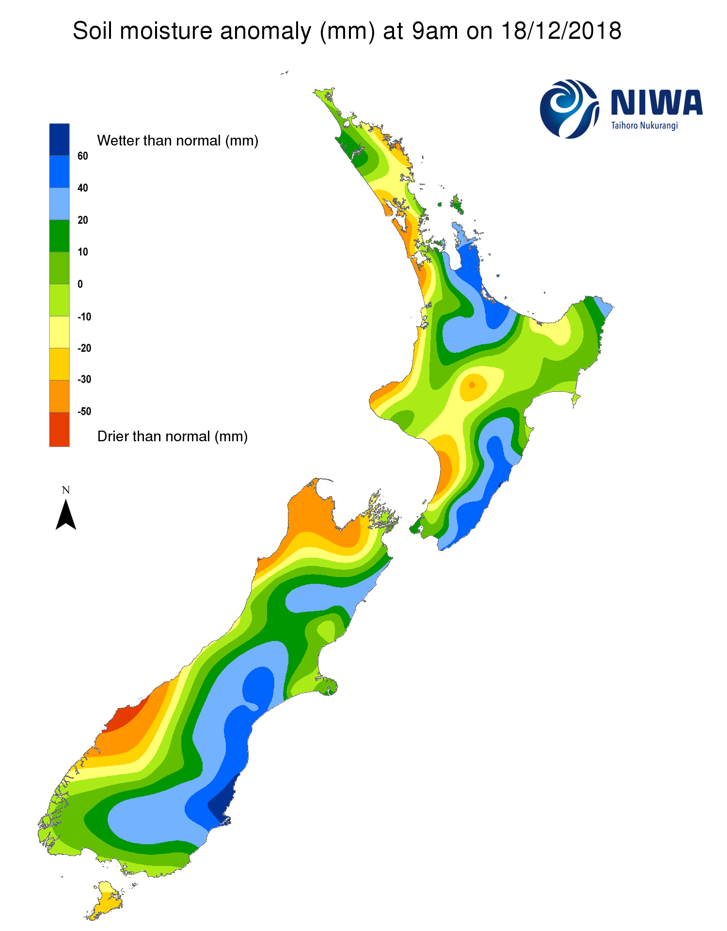
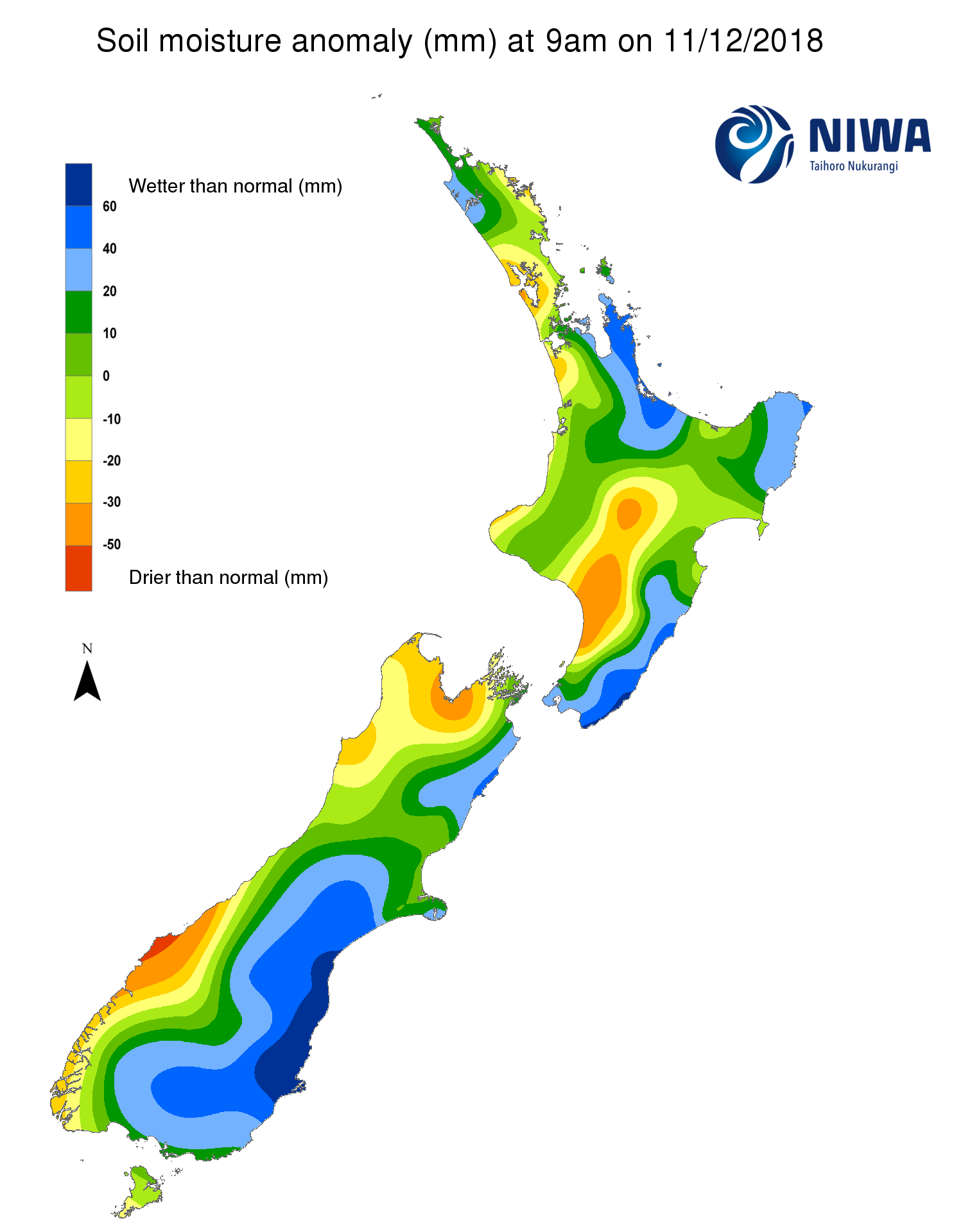
Pictured above: Soil Moisture Anomaly Maps, relative to this time of year. The maps show soil moisture anomaly for the past two weeks.
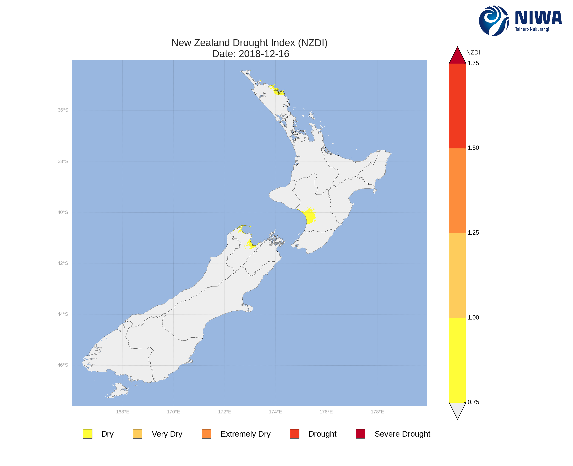
The New Zealand Drought Index (NZDI) map below shows continuing dry areas across the North Island and upper South Island as of 16 December. Please note: the soil moisture anomaly map may not correspond with the NZDI map, mainly because the NZDI uses additional dryness indices including one which integrates the rainfall deficit over the past 60 days. Changes are therefore slower to appear in the NZDI compared to the instantaneous status maps of soil moisture anomaly.
Background:
Hotspot Watch: a weekly advisory service for New Zealand media. It provides soil moisture and precipitation measurements around the country to help assess whether extremely dry conditions are imminent.
Soil moisture deficit: the amount of water needed to bring the soil moisture content back to field capacity, which is the maximum amount of water the soil can hold.
Soil moisture anomaly: the difference between the historical normal soil moisture deficit (or surplus) for a given time of year and actual soil moisture deficits.
Definitions: “Extremely” and “severely” dry soils are based on a combination of the current soil moisture status and the difference from normal soil moisture. Refer to soil moisture maps for more information.